Extending from the Montclair hills to Dimond Park near Fruitvale Avenue and Macarthur Boulevard is an expanse of wooded open space called Dimond Canyon. Hundreds of cars drive by the canyon on Park Boulevard every day. Only a few enjoy the wildlife of the canyon at its best, by hiking the trails that run through the woodlands. Some of these trails have been used since people first inhabited these hills.
At the head of the canyon, near Highway 13, Cobbledick Creek (which runs along Scout Road) joins Shephard Creek (which runs under Shepherd Canyon Road). On the bay side of the freeway, near the parking lot of the Montclair Golf Course, these creeks join Palo Seco Creek (which runs through Joaquin Miller Park) and unite to form Sausal Creek which runs through the bottom of Dimond Canyon. Huchiun and Jalquin tribes of Ohlone Indians were concentrated in the area surrounding Dimond Canyon. One well-known Indian village was located in Indian Gulch, the area currently called Trestle Glen. Another known village was located on the campus of Holy Names College. Dimond Canyon was between them. The hillsides of the canyon would have been great sites for harvesting acorns, berries, and edible plants, and hunting for birds, fish, and other wildlife.
In 1820, the land including Dimond Canyon was granted to Luis Maria Peralta. Peralta owned all the land from El Cerrito to San Leandro, but he chose to place his first home on the flatlands between Peralta and Sausal Creeks. Peralta divided his land among his sons in 1842 giving the San Antonio section including Dimond Canyon and his original home to his son Antonio Maria Peralta.
Around 1847, Europeans set up camp in the upper hills of Antonio Peralta’s land, and started logging the San Antonio redwood forest. In 1850, the area’s first steam sawmill was built at Palo Seco Creek in the head of Dimond Canyon. A logging road high on the side of the Canyon, now Park Boulevard, was used to transport the logs through Dimond Canyon. By 1860, ten years later, the San Antonio forest was logged completely.
In 1867, Hugh Dimond purchased the canyon. Before he came to settle the land, Caspar Hopkins, another early settler of the Fruitvale District, formed the Sausal Creek Water Company. Hopkins built a dam at the upper end of the canyon near current Highway 13. He piped the water down the hill along the East Side of the creek to a reservoir at what is currently Waterhouse Road. The water was used to supply the Fruitvale District and for a short time all of East Oakland after the company was bought by Anthony Chabot’s Contra Costa Water Company. The reservoir later became part of the East Bay Water Company and remained until the early 1920’s. Maps of this early period show a road passing the reservoir along the current Waterhouse Road, and extending up toward the dam in the direction of Bridgeview Drive along what is currently the Upper Dimond Canyon Trail.
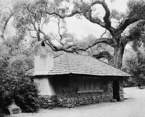
Hugh Dimond retired to his land in 1877 on the fortune he made in the mercantile and liquor trades during the Gold Rush. He built his home in the lower stretches of the canyon in what is currently Dimond Park. In 1896, the year of Hugh Dimond’s death, his son Dennis moved the adobe bricks from the original Peralta home to the area of Dimond Park, and built a studio cottage. The main Dimond house burned in 1913, leaving the adobe cottage. Four years later, the Dimond family sold the property to the city.
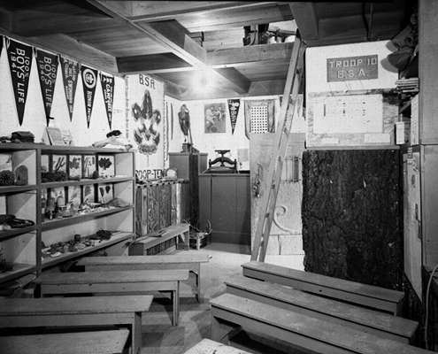
Dimond Canyon then became home to the Boy Scouts. In 1919, Camp Sheoak was conducted by the Oakland-Piedmont Council of the Boy Scouts of America in Dimond Canyon. In 1924, the adobe cottage in Dimond Park became the headquarters of Boy Scout Troop 10.


At the head of the canyon, in the area of the current Scout Road and Montera and Joaquin Miller schools, was located Camp Dimond, a 28 acre summer camp for Scouts. In a 1933 scout magazine, camp director Homer J. Bemiss invited scouts for $14.00 for two weeks (including meals) to enjoy the 140 ft. mess hall, the 300,000 gallon swimming pool, the bird sanctuary, and nature den. Accommodations included 24 cabins, tents, and an Indian village where scouts could live in tipis. The site also boasted a stockade built upon the “military crest” at the top of the canyon with a view of Dimond Canyon and East Oakland.
During the 1920’s development was occurring in areas surrounding the canyon. By 1926, Walter H. Leimert had built the largest single span bridge in the west, spanning the canyon at Leimert Boulevard. This opened up the way for his development of the Oakmore Highlands.
In 1935, the Works Progress Administration began work deep in the canyon. Initially they were funded to clear landslides and build fire trails. In 1937, the WPA constructed a sanitary sewer that runs adjacent to Sausal Creek under the creek-side trail that runs from Dimond Park to slightly beyond the Leimert Bridge. In 1939 and 1940, further work was done to channelize the creek in concrete and stabilize its banks.
In 1946, Oakland Park Superintendent William Mott Jr., who had designed the Woodminster Cascades in 1937, had grand plans for Dimond Canyon. Engineering studies were done for construction of a 350-foot long, 80-foot high dam in the Canyon with the idea of creating Inspiration Lake at the site of the current Montclair Golf Course. The lake was to include a bathhouse, boathouse, and clubhouse, and a 20-mile long scenic parkway along the southeastern wall of the canyon. Much of this road was to run along the former reservoir road that is currently the Upper Dimond Canyon Trail. In the 1950’s, construction of the Mountain Boulevard Freeway, later called the Warren Freeway or Highway 13, interrupted these plans. Plans for the lake were changed to plans for a driving range, and in 1961, the Montclair Golf Course opened at the head of the canyon. Sausal Creek is buried under the course.
From 1975 to 1995, the trails in the Dimond Canyon area were developed and maintained by a joint agreement between the City of Oakland and the East Bay Regional Park District. During the early years of the agreement, CETA (Comprehensive Education and Training Program) funds were used for trail maintenance and to construct a bridge at the Monterey Boulevard end of the Upper Dimond Canyon Trail. During the later part of the agreement, trail maintenance was reduced as funding cuts to both agencies limited their ability to maintain the site. The CETA bridge installed in 1977 was removed after someone tried to cut the support cables. A small concrete bridge was built to cross the trail in its place.
In 1996, the Friends of Sausal Creek was formed with support from the City of Oakland, the Aquatic Outreach Institute, and the Alameda County Flood Control and Water Conservation District. The group is interested in the entire Sausal Creek Watershed, and has organized clean-up hikes within the canyon, water quality monitoring of the creek, and has planted a native plant garden and a riparian restoration site at the lower end of the hiking trail in Dimond Park.
by Eleanor Dunn (longtime Friend and Acting Treasurer), from The Montclarion, March 24, 1998

Thankyou so much for the history of places in my heart. I grew up in Oakland; attended St. Jarlath’s in Dimond, and also Marylrose, (which was adjacent to Holy Names high school) and Oakland High. I have fond memories of walking all over Oakland with my friends…Laurel district, Montclair, Dimond, etc. It was nice to read the familiar names of the early developers. I lived on Rhoda Avenue and later on Florence, off of Broadway Terrace. The sight of the Oakland hills was always a source of comfort and stability for me. Before the Mormon Temple was built my best friend and I referred to the area as ‘the Moon’ because there were large strange boulders there and we used to jump from one to the other. Thankyou for the information and the memories. ~L~
Thank you, this is great history. Do you know if there was an environmental impact report done when construction of highway 13 was planned? I have a feeling all the watershed was disrupted and we have few creeks here and there!
Anyway, I collecting data to what was there in terms of hydrology and the ecosystem before highway 13 and how to conserve better the current creek system.
Cheers!
Luigi
Just Before the line “In 1935″…..You could add:
As part of the Leimert Oakmore development, the first sanitary sewer line was run down the canyon from just above the Leimert bridge, about an 18″ diameter pipe, connecting with the existing older main sewer line (which runs more or less along the Hiking Trail) at just below El Centro Ave, near Dimond Park in the late 1920s. The new houses along Oakmore Road and nearby streets were connected in by laterals to this line also.
(Then)
in 1937 this line was replaced in stages by about a 30” diameter pipe by the WPA. The work was done in the wet, with the old sewer being dug out, and the new pipe (a concrete pipe) being put in place downstream and the water being pumped around the working site. The new sewer was then further extended up to Montclair and later beyond, where there had been no sewer system previously.
Remark: I lived there then and supervised this project as a small boy…
thank you for the information lived in the dimond district when i first moved from san francisco. it was very nicely placed as i walk through sausal creek with my dog. i really appreciate its beauty.can understand the love and sincerity that the friends of sausal creek has and why. thanks for taking me to the beginning…. deborah
I almost lived in Diamond Park from the mid 50s till the late 60’s. I was one of many who considered themselves as the Diamond Gang. We consisted of a group of kids from all the neighborhoods surrounding the park, many of us learned to swim at the Diamond pool, spent our parents hard earned money at the snack bar, we were or had been Cub/Boy Scouts at the old club house and the remodeled Rec Center. We knew every inch of the park from the driving range down to all 3 of the park entrances. We swam in the creek, strung a rope from the center of the Montclair Bridge and swung from one side of the canyon to the other. If things were going bad at school or at home, we knew we would be welcomed at the park.