(click to enlarge photos)


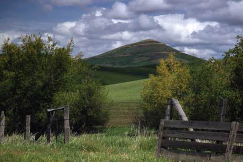
I imagine that among PacificNW readers many have explored this magazine’s namesake surrounds via its many adventurous roads and highways. And I’m confident that among these explorers, several will have driven to within a few feet of this week’s featured subject, but then missed it. Jean Sherrard estimates that he has made about twenty visits to this basalt bluff above the Yakima River. First, of course, he had to find it by studying the photographer-essayist Hugh Paradise’s featured photograph. At legal speed it takes about two-and-a-half hours from Seattle to reach the half-paved shoulder that Jean describes as “a little triangle squeezed between Washington State Route 821 and about a two-hundred-foot fall into the Yakima River.” Sensibly, the Washington State Department of Transportation has set no “park here” signs marking Jean’s postage-stamp sized “parking lot.” It can be by found following the ensuing instructions.


About four miles south of Ellensburg the now nearly century-old Yakima River Canyon Road, while keeping for the most part close to the river, follows the eroding trout stream’s serpentine cut through the Umtanum Ridge. The Ridge takes up most of the skyline in the now-and-then photos. The highway curves its way through about ten oxbows (that is twenty curves, some of them hairpins) on its way to the lower Yakima Valley. After about the eighth curve, the Canyon Highway reaches the landmark Red’s Fly Shop, which is actually a sumptuous lodge, and begins a half-mile climb to the unmarked Paradise/Sherrard petite parking place. At the top if you suddenly enter a highway regrade that cuts through the bluff you were just ascending, you have gone a few feet too far. Turn around and try again.
The artist Hugh Paradise was born in 1912 in Montana and died in Seattle in 1979. His Post-Intelligencer obituary described him as a “retired free-lance writer and photographer, who resided in the Seattle area for over 40 years.” I have studied and admired Paradise since a friend shared a few hundred of his negatives with me several years ago. His name fits. Paradise wrote short essays illustrated with his arcadian photographs for Sunset Magazine. An

appreciative Sunset editor described him to me as “poetic.” He married Anne Marie Van Cleve in 1942, whom he frequently posed in the middle-distance of the northwest landscapes that attracted him. Paradise was also exceptionally smart. He belonged both to Mensa and the Triple Nine Society, gregarious and inquiring societies for people with high intelligence scores. His obituary describes his “major interest” as “the world about him.”

Hugh Paradise had a handicap, a breathing condition that prevented him from ranging far into the scenery he photographed. For this photo high above the Yakima, he was forced to stay near the side of the road. In the 1960s, this magazine’s predecessors, The Seattle Times “Charmed Land Magazine” and The Seattle Times “Color Rotogravure, the Sunday Pictorial Magazine,“ published several examples of Hugh Paradise’s intimate art. While I never met him, I continue to collect him.
WEB EXTRAS
Anything to add, lads?
Starting with you Jean. First dear readers, we have encouraged Jean to include some of the photos he has taken during his many visits to the Yakima Canyon. They are grouped directly below the feature text, that is, between it and this answer to Jean’s by now conventional question about “extras.”
Hey, Paul – here are a few selections of the canyon from over the years. The first set repeat Paradise’s shot in different weathers and seasons. The second are a handful that I dug up at the last minute. Enjoy.
Ah but we have very little in the way of our own Times features that cover the state’s “dry side” subjects. Choosing to pull neither text nor photos from “Building Washington,” the History of Washington State Public Works that we published years ago, which is filled with images from every corner of the state, we have played it convenient and linked first a feature on the dedication of what we popularly call the Mercer Island Floating Bridge. We do it for the sufficient reason that our featured photo looks to the east in the direction of Yakima, as do the second, third and fourth links below. For the last of these, this week, eleven links we shall pivot far north to the wet side of Alaska with the feature built on Jean’s recent visit to Juneau. Following those we will sprinkle a few of the east side (of Washington State) subjects that we pulled three years ago for the “Our Daily Sykes” feature, which printed here a few hundred photographs taken by Horace Sykes, mostly in the 1940s, of his trips around Washington – and the West too – as a sensitive fire insurance adjuster with a good camera and eye for picturesque compositions. And we will likely find a few other images that touch on Yakima, the river or the city too.
=====
HORACE SYKES NEARBY THE RIVER
First will show a few photos of Horace. His home was above the beach in Magnolia.


Paul, it brought me great pleasure to see that one Hugh’s photos made it to the Now and Then section this Sunday (11/13/16) in the Seattle Times. It was my mother and me that brought you those photos, my mother was the court appointed guardian for Anne, and on her passing was in charge of all of the arrangements of her estate, which included us bring you those photos. I recall being somewhat apologetic that most of the photos were of nature and the outdoors, and not of more identifiable buildings or other more recognizable items. It is fantastic you and your team was able to correlate the Then scene with the Now. It would be nice if you would correct the “courtesy of” acknowledgement to her, Thelma Coney.
Beautiful photographs!