

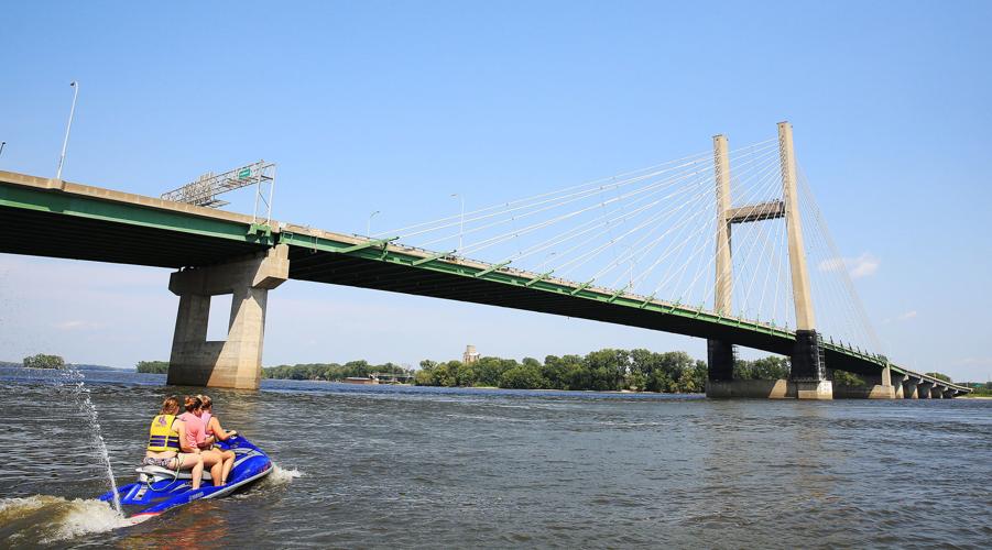


BURLINGTON, Iowa — Nausea struck almost immediately after hitting the water.
Paddling a 16-foot sea kayak against the wind and current in Pool 19 of the Mississippi River, I regretted having a smoked catfish fillet for lunch and a soft-serve ice cream cone for dessert.
The motion sickness waned, though, as we entered calmer backwaters; protected by a chain of islands north of the Great River Bridge.
Separated from barge traffic, the secondary channel resembles a smaller, slower river, prime for spotting flyover eagles and sunning turtles. Exploring this wildlife-thick segment alongside Steve Klein, Burlington-based canoeing/kayaking instructor, presented a special perspective.
“The Mississippi has this stigma of being a dangerous industrial waterway, but it doesn’t have to be a scary experience,” he said. “You don’t have to go far behind the main channel to find quiet sloughs that are excellent paddling locations.”
People are also reading…
The southeastern-most part of the state may not have the same reputation as the Driftless Area of northeast Iowa, for instance, but river town residents down here take pride in their surroundings, too. It took more than one visit to realize it, but the section between Burlington and Keokuk also is a destination for outdoors enthusiasts and river-culture admirers.
“We feel like we’re a forgotten part of Iowa, but we are a very unique area,” Keokuk Mayor Tom Richardson said. “You’re here because you want to be here.”

Cyclists make their way south along Mississippi River Road toward Keokuk, Iowa.
Home on Big Island
It takes Craig Petersen 30 minutes to get to his happy place.
“I live on the south side of Burlington; just to make it easier to get to my boat,” he said during a recent ride on his 14-foot flat-bottom. “I wouldn’t live here if the river wasn’t here.”
Petersen stores two boats at Cascade Boat Club near the Hawkeye Log Cabin — a museum with a river view that depicts the life of Iowa settlers.
During the spring, summer and fall, he spends a lot of his time east of the main channel (in Illinois, technically) at Burlington Island; called Big Island by locals.
The 65-year-old father of two has an elevated cabin along the wooded eastern shore and belongs to Ed’s Cascade Fishing & Hunting Club. Petersen is the longest-running member of the group, founded by his grandfather’s stepdad in 1954.

Lifelong Burlington, Iowa, resident and outdoors enthusiast Craig Petersen explores Pool 19 of the Mississippi River near Burlington Island, which locals call Big Island.
The club owns about 220 acres on the sprawling isle with four-wheeling trails and navigable inlets. Petersen, an avid duck hunter who works at the Iowa Army Ammunition Plant in nearby Middletown, maintains two blinds on separate waters that cut into the island’s interior.
“It’s a well-kept secret down here,” he said. “Even people in Burlington don’t know about it.”
In 2003, Chad Pregracke and his Living Lands & Waters crew conducted cleanups in the area and planted a variety of trees on Big Island. Not all of them have survived because of flooding, but the environmental group from East Moline made its mark.
Ed’s Cascade Fishing & Hunting Club is hosting a public chicken fry Saturday, Aug. 18, at its clubhouse on the island, and anyone is welcome to attend. “Bring your friends,” Petersen said. “We’ll pick you up and get you back.”
The event is a fundraiser for the “poor man’s club,” which has about 50 members, he said. “Anybody can join.”
‘This is my paradise’
Compared to the river communities of the Quad-Cities and Dubuque, Petersen said, Burlington is stagnant.
“We struggle to keep young people here, because we don’t have the jobs,” he said. “We haven’t grown like we should.”
The city’s population in 2010 was a little more than 25,000, according to Census data.
Klein, the kayak instructor, grew up in a boating family and owns River Basin Canoe & Kayak on the outskirts of town. He estimates Burlington now has closer to 20,000 people, and he's noticed a corresponding dip in recreation on the river.
“These islands were jam-packed with boats,” Klein, 60, said of summer weekends during his childhood. “We’ve largely gotten away from outdoors activities.”

Paddling instructor Steve Klein, owner of River Basin Canoe & Kayak, pauses during a recent kayaking outing upriver from the Great River Bridge in Burlington, Iowa.
Although Petersen’s two children live in the Chicagoland area, his ties to boating, fishing, four-wheeling and hunting along the Mississippi and its sloughs have kept him here. They keep some of his family members coming back, too.
After touring his club’s property and hunting grounds on a recent Sunday, we stopped by his riverfront cabin on Big Island, where he grows bananas and pumpkins, among other things.
“You can’t beat it,” he said, sipping a beer on his deck. “This is my paradise.”
Toll or no toll, a popular route
As towns south of Burlington shrink in population, the river widens.
Scenery along the 50-mile loop on both sides of the water between the Fort Madison Toll Bridge and the Keokuk-Hamilton Bridge attracts sightseers.
Tourists interested in making the trip may want to enter into Illinois from Keokuk, rather than Fort Madison. To go from Fort Madison to Niota, Illinois, motorists must pay a $2 toll; motorcyclists are charged $1. Meanwhile, there is no fee for Iowa-bound vehicles.
Similar to the Government Bridge between Davenport and Rock Island, river traffic may cause delays at the Fort Madison Toll Bridge. Getting “barged,” as locals call it, happens when the swing span opens to permit boats to pass.

The historic Old Fort Madison is now a museum on the riverfront in Fort Madison, Iowa. It is the Midwest's oldest American military garrison on the Upper Mississippi River. The fort is open 9 a.m. to 5 p.m. Wednesday-Sunday, through Sept. 9.
Motorcyclists especially enjoy the loop, which offers great roadside views between Montrose and Keokuk on the Iowa side and Hamilton and Nauvoo on the Illinois side.
At one of the widest points on this stretch last month, I met motorcyclist Elizabeth Johnson at Linger Longer Rest Area, near the intersection of U.S. 61 and Mississippi River Road, just north of Montrose.
The solo rider, who wore two bandanas that covered most of her face and leather chaps to protect her legs, dismounted a Harley-Davidson.
“It’s pretty watching the river,” said Johnson, an Illinois resident. “I don’t care where I’m going; I just like to ride with the wind in my face.”
‘The Florida of Iowa’
A few miles down the road, a surprise supper of chicken noodle casserole and watermelon was offered and plated upon my arrival at Pelican Peg’s Riverfront Bed & Breakfast, just south of Montrose.
“It’s impossible to cook for just one person,” said Margaret “Peg” Aicher, who has hosted hundreds of visitors since opening a room in her home to travelers in 2007.
Tucked in the middle of her childhood neighborhood, “where everybody knows everybody,” bright colors, seashells and an assortment of wooden fish and pelicans decorate the ins and outs of Aicher’s clean, cozy ranch-style house.
“We’re in the Florida of Iowa,” she said of the beach motif. “What do you expect?”

Self-proclaimed river rat Margaret “Peg” Aicher runs Pelican Peg’s Riverfront Bed & Breakfast on the shore of the Mississippi River just south of Montrose, Iowa.
Keokuk Mayor Tom Richardson, who owns a cabin near Pelican Peg’s, drew the same comparison, so it evidently is a thing. He acknowledged many residents in the area talk with a “southern twang,” and they enjoy warmer temperatures than the rest of Iowa.
“We’re in a whole ‘nother climate zone,” he said.
Additionally, the shape of southeastern Iowa, bordered by the Des Moines River to the west and the Mississippi River to the east, looks like that of the Sunshine State.
Catering to all types of travelers
Although secluded, Pelican Peg’s is positioned between the river and railroad tracks, so noisy barges and coal trains often make their presence known.
Many guests, however, enjoy the industrial surroundings.
Aicher, a 70-something retired teacher, is divorced with two children and two grandchildren. She launched her B&B 11 years ago to keep things interesting.
“It gets a little busier as I go,” said Aicher, who advertises her accommodations on Airbnb for $69 per night. “I’m not a destination, more of a travel-through place.”

A sailboat anchored on the Montrose riverfront Thursday, August 10, 2017. The area was strategically important historically because it is at the head of the Des Moines Rapids, a major impediment to river traffic that caused large boats to land in this area and transfer freight overland to avoid the rapids. Montrose was the location of Fort Des Moines No. 1, a military post from 1834-1837.
She has welcomed, served and befriended strangers from all over the world, including artists, authors and adventurers off the river. A passing kayaker once paddled to shore in search of a room for the night.
“It’s company,” Aicher said. “I’d be here by myself otherwise.”
She's rarely alone on Thursdays, though. That's when a group of girlfriends comes over to play euchre, a popular card game in the Midwest.
"That's a big deal around here," she said of the game.
A sliding barn door separates the guest area at Pelican Peg’s from the rest of the house, just 50 feet from the water. Designed for couples, the wing includes a private bathroom and a large bedroom with a king-size bed. There is TV and Wi-Fi, too, but the view from the deck off of the bedroom is the real attraction.
Aicher also is a regular host to members of The Church of Jesus Christ of Latter-day Saints, commonly referred to as Mormons, who come here to visit the historic town across the river, Nauvoo. The religious group’s founder, Joseph Smith, established a settlement there in 1839. His followers later constructed the Nauvoo Temple, which towers above the Mississippi. Every summer, they host the Nauvoo Pageant, a 3½-week tribute to Smith and the church's roots in this area.
My recent stay coincided with the 14th annual celebration.
‘Fascinating to watch’
The alarm rang at 5:30 a.m. the next day, just in time to catch the sunrise from the Mississippi shoreline, the best seat in the house.
Fish splashed on the water’s surface as the sun steadily climbed above the horizon and illuminated the Iowa coast. Waking up to the sun’s warming rays and capturing time-lapse images of it was an ideal way to begin the day.
Breakfast started with a deliciously fresh green smoothie, dubbed “swamp juice” by a pair of previous guests. A blended mix of fruits and vegetables, it contained cucumber, kale, spinach, carrots, bananas and grapes. The main course included a full plate of ham steak, eggs, fruit and banana-walnut bread with coffee and orange juice.
We sat across from each other at the table on Aicher's deck and enjoyed the early-morning sounds of nature rising.
“I suppose I’m a river rat,” she said after a while. “We appreciate where we live.”
Shortly after breakfast, a lone fisherman appeared near the shore. Taking advantage of his day off, Joe Bohnekamp, an employee at the Iowa State Penitentiary in Fort Madison, was casting for bass from his 18-foot boat. Using a rubber frog for bait, he reeled in and released a sizable largemouth.
“I never knew we had bass in here,” Aicher said. “There’s always something really fascinating to watch.”
Finding ‘treasure’ in Keokuk
Amid the flurry of Florida-themed trinkets around the entrance to Pelican Peg’s lies a sparkling slice of Iowa.
The pair of crystal-lined geodes went unnoticed until I backed out of Aicher’s driveway for Keokuk, the hotbed for Iowa’s state rock.
Although geodes can be found in various places around the world, an abundance of the rocks are collected within a 35-mile radius of Iowa’s southeastern-most city. Foragers recognize the tri-state area, where the borders of Iowa, Illinois and Missouri meet at the confluence of the Des Moines and Mississippi rivers, as the epicenter of the internally shiny rocks.

Rock hound Kirk Brandenberger, executive director of the Keokuk Area Convention & Tourism Bureau, holds two sides of a geode, Iowa’s state rock, he split open with a pipe cutter.
“Geodes are probably our number one tourism draw,” said Kirk Brandenberger, executive director of the Keokuk Area Convention & Tourism Bureau. “People are here almost on a daily basis hunting geodes. It’s a great family activity away from the TV and out in nature.”
Round, rough and dingy on the outside, most Iowa geodes measure between 2 and 6 inches in diameter and contain a variety of minerals, primarily quartz, according to the Iowa Department of Natural Resources. In this region, geodes evolved in bubbles of sedimentary rock roughly 350 million years ago, about the time glaciers were receding from this part of the Earth. Over time, mineral-filled water flowed through the hollow areas of rock and formed crystals.
Prevalent along creek beds in the area, high-quality geodes are light and hollow. Brandenberger, whose office features dozens of unopened geodes and a tool to split them open, offered this strategy to aspiring rock hounds and hunters: “Pick up two stones and weigh them. If one is extremely heavy, throw it down and keep getting lighter ones.”
During the last weekend in September, about 1,500 people from around the country are expected to visit Keokuk for the 14th annual Geode Fest and Rock Show.
Keokuk and Fort Madison share the county seat of Lee County, and as of the 2010 Census, populations in Keokuk and Fort Madison were 10,780 and 11,051, respectively.
In 2016, Lee County ranked 21st out of Iowa’s 99 counties in tourism expenditures, which totaled about $62 million, Brandenberger said.
While the Nauvoo Pageant provides a big economic boom each year for Keokuk, geodes attract the majority of visitors to the small town.
“Local folks take ‘em (geodes) for granted,” Brandenberger said. “To other folks, away from here, they’re a treasure.”
PHOTOS: THE GREAT RIVER - 400 miles of the Mississippi
THE GREAT RIVER-0900

Located along the Mississippi River in the southeast corner of Iowa Fort Madison, Iowa has a population of 11,000.
THE GREAT RIVER-0901

Old Fort Madison Site Manager Dr. Eugene Watkins looks across the site August 10, 2017.
THE GREAT RIVER-0902

The former Iowa State Penitentiary facility in Fort Madison had been empty since its inmates were moved on August 1, 2015 to the new facility completed in 2014. A nonprofit, Historic Iowa State Penitentiary Inc., is seeking funds to preserve the structure. An open house at the old site drew big crowds May 7, 2017, encouraging local residents who want to preserve the historic structure, parts of which date to 1839. The crowd, estimated to be in the thousands, lined up to get a look at the penitentiary, a landmark previously closed to the general public.
THE GREAT RIVER-0903

The former Iowa State Penitentiary facility in Fort Madison had been empty since its inmates were moved on August 1, 2015 to the new facility completed in 2014. A nonprofit, Historic Iowa State Penitentiary Inc., is seeking funds to preserve the structure. An open house at the old site drew big crowds May 7, 2017, encouraging local residents who want to preserve the historic structure, parts of which date to 1839. The crowd, estimated to be in the thousands, lined up to get a look at the penitentiary, a landmark previously closed to the general public.
THE GREAT RIVER-0904

The authentically reconstructed buildings at the old Fort Madison site allow visitors to experience daily life of the men, women, and children who inhabited this factory post from 1808 to 1813.
THE GREAT RIVER-0905

Looking out to the Mississippi River through at the old Fort Madison stockade walls which are made of logs placed side by side vertically with the tops sharpened to provide security.
THE GREAT RIVER-0906

Fort Madison was attacked numerous times during the War of 1812. The fighting around the fort began with Winnebago harassment in March and April 1812, which killed two soldiers. In September 1812 Fort Madison was targeted as part of Tecumseh’s Offensive and sustained a four-day siege in which one soldier was killed. Again in April and May 1813 the post was harassed by hostile warriors allied to the British. In July 1813 six soldiers were killed in two separate skirmishes outside the fort. Periodic harassment continued until the fort was finally abandoned in November 1813 due to the failure of the contractor to supply the fort with usable rations.
THE GREAT RIVER-0907

Old Fort Madison Site Manager Dr. Eugene Watkins talks about all the items bought and traded for with Native American tribes at the site on the Fort Madison, Iowa riverfront August 10, 2017.
THE GREAT RIVER-0908

Old Fort Madison Site Manager Dr. Eugene Watkins demonstrates how to load and fire a 1795 U.S. Model Springfield smooth bore 69 caliber flintlock musket.
THE GREAT RIVER-0909

Old Fort Madison Site Manager Dr. Eugene Watkins demonstrates how to load and fire a 1795 U.S. Model Springfield smooth bore 69 caliber flintlock musket.
THE GREAT RIVER-0910

Old Fort Madison Site Manager Dr. Eugene Watkins demonstrates how to load and fire a 1795 U.S. Model Springfield smooth bore 69 caliber flintlock musket.
THE GREAT RIVER-0911

Old Fort Madison Site Manager Dr. Eugene Watkins at the site on the Fort Madison, Iowa riverfront August 10, 2017. The old fort is the Midwest's oldest American military garrison on the upper Mississippi River. The fur trading post on the frontier of the Missouri Territory was home to Captain Horatio Stark's Company of the First Regiment, United States Infantry, from 1808 to 1813.
THE GREAT RIVER-0912

During a tour with family members 10-year-old John Kennedy of La Grange, Missouri. happily got in the jail cell at the North Lee County Historical Society Museums at 814 10th Street in Fort Madison, Iowa.
THE GREAT RIVER-0913

A display of all the inmates that were hanged in the penitentiary outside the jail cell at the North Lee County Historical Society Museums at 814 10th Street in Fort Madison, Iowa. Before the abolition of capital punishment in Iowa, executions were performed at Fort Madison. An interesting note in the history of the prison was the execution of Victor Feguer. Feguer was a drifter who had murdered Dubuque doctor Edward Bartels. After appeals that went as far as President John F. Kennedy were denied, Feguer was executed by hanging on March 15, 1963. Feguer was the last inmate in the Federal prison system to be put to death for nearly 40 years until the execution of Timothy McVeigh at the Terre Haute, Indiana Federal Prison in 2001.
THE GREAT RIVER-0914

North Lee County Historical Society Museums volunteer Andy Andrews explains how an Edison Phonograph player operates to members of the Kennedy family from La Grange, Missouri August 10, 2017.
THE GREAT RIVER-0915

The Way Car, known by most as "The Caboose" is located outside the North Lee County Historical Society on the Fort Madison riverfront.
THE GREAT RIVER-0916

Inside the Way Car, known by most as "The Caboose" is located outside the North Lee County Historical Society on the Fort Madison riverfront.
THE GREAT RIVER-0917

Kids ride down a carnival slide during a fair in Fort Madison, Iowa, on Thursday, August 3, 2017.
THE GREAT RIVER-0918

Inside the Way Car, known by most as "The Caboose" is located outside the North Lee County Historical Society on the Fort Madison riverfront.
THE GREAT RIVER-0919

Oakland Cemetery in Fort Madison is home to Soldier's Circle, where former and present City of Fort Madison residents who qualify as veterans under the Iowa Department of Veteran's Affairs requirements may be interred. A Memorial Day Service is held each year at Soldier's Circle followed 30 minutes later by a memorial service at the Veteran's Memorial in Riverview Park.
THE GREAT RIVER-0920

A road sign noting distances and direction to points of interest both near and far on the Mississippi River Road in Montrose, Iowa
THE GREAT RIVER-0921

Dave's Old Fashion Meats on North 1st Street (Mississippi River Road) in Montrose, Iowa.
THE GREAT RIVER-0922

Dave's Old Fashion Meats on North 1st Street (Mississippi River Road) in Montrose, Iowa is popular with locals but has a customer base the reaches out hundreds of miles.
THE GREAT RIVER-0923

Dave Beelman opened Dave’s Old Fashion Meats in Montrose on July 5, 2004 and has enjoyed enormous success in the small community ever since. Known for tender aged, corn-fed beef, hand cut tenderloins, smoked meats, home-made sausages and brats, and products made from customers boneless deer meat.
THE GREAT RIVER-0924

A plaque noting Montrose was the birthplace of Cal McVey, Iowa's first professional baseball player outside the Montrose Riverfront Heritage Center Museum.
THE GREAT RIVER-0925

A sailboat anchored on the Montrose riverfront Thursday, August 10, 2017. The area was strategically important historically because it is at the head of the Des Moines Rapids, a major impediment to river traffic that caused large boats to land in this area and transfer freight overland to avoid the rapids. Montrose was the location of Fort Des Moines No. 1, a military post from 1834-1837.
THE GREAT RIVER-0926

The area around Montrose, Iowa has been occupied continuously since at least the 1780s, when Quashquame's village was established nearby. From 1839-1846 Montrose was the home of many members of the Church of Jesus Christ of Latter Day Saints. This was especially true in 1839 when many people lived in an abandoned barracks at Montrose that served as a good short term residence while homes were being built in Nauvoo. Among Montrose's residents at this time were Brigham Young, Wilford Woodruff and Erastus Snow. Despite legends that the streets of Montrose were aligned to allow a direct view of the Nauvoo Temple across the Mississippi River in Illinois,[5] the streets actually align with the 1834 layout of Fort Des Moines.
THE GREAT RIVER-0927

A staircase is seen leading up to a residence at The Edge of the River campground in Dallas City, Illinois, on Thursday, August 3, 2017.
THE GREAT RIVER-0928

An old air boat is seen at The Edge of the River campground in Dallas City, Illinois, on Thursday, August 3, 2017.
THE GREAT RIVER-0929

Posted prices and a check-in dropbox are seen at The Edge of the River campground in Dallas City, Illinois, on Thursday, August 3, 2017.
THE GREAT RIVER-0930

Groundskeeper Catherine Whitmore gives a tour of the shoreline at The Edge of the River campground in Dallas City, Illinois, on Thursday, August 3, 2017.
THE GREAT RIVER-0931

A "leanin' post" bar top is seen along the shore of the Mississippi River at The Edge of the River campground in Dallas City, Illinois, on Thursday, August 3, 2017.
THE GREAT RIVER-0932

Open camp sites along the river are seen at The Edge of the River campground in Dallas City, Illinois, on Thursday, August 3, 2017.
THE GREAT RIVER-0933

Groundskeeper Catherine Whitmore walks along the shoreline talking about cleanup work in progress after flooding at The Edge of the River campground in Dallas City, Illinois, on Thursday, August 3, 2017. Whitmore says the work seems to be a never-ending project but cherishes it as it helped her through a difficult divorce and also helped her lose a lot of weight because of her more active lifestyle.
THE GREAT RIVER-0934

A fishing boat is seen on shore of a small fishing pond at The Edge of the River campground in Dallas City, Illinois, on Thursday, August 3, 2017.
THE GREAT RIVER-0935

Campers are seen set up in their spots at The Edge of the River campground in Dallas City, Illinois, on Thursday, August 3, 2017.
THE GREAT RIVER-0936

A pair of binoculars are seen hanging through a window reflecting trees at The Edge of the River campground in Dallas City, Illinois, on Thursday, August 3, 2017.
THE GREAT RIVER-0937

A number of classic car signs are seen on a building in Dallas City, Illinois, on Thursday, August 3, 2017.
THE GREAT RIVER-0938

Illinois state route 96 is seen passing through Dallas City, Illinois, on Thursday, August 3, 2017.
THE GREAT RIVER-0939

A neighborhood street along the Mississippi River at Ernie Pyle Drive and Mustard Street is seen in Pontoosuc, Illinois, on Thursday, August 3, 2017.
THE GREAT RIVER-0940

The Stephen L. Colby tow of Marquette Transportation is seen traveling along the Mississippi River in Pontoosuc, Illinois, on Thursday, August 3, 2017.
THE GREAT RIVER-0941

The architecture and scaffolding of the Highway 9 bridge is seen Niota, Illinois, on Thursday, August 3, 2017.
THE GREAT RIVER-0942

The grave site and family home of Joseph Smith, an American religious leader and founder of Mormonism and the Latter Day Saint movement, is seen in Nauvoo, Illinois, on Thursday, August 3, 2017.
THE GREAT RIVER-0943

The Pioneer Memorial shelter is seen alongside the Mississippi River in Nauvoo, Illinois, on Thursday, August 3, 2017.
THE GREAT RIVER-0944

Tourists walk up to the shore of the Mississippi River at the Pioneer Memorial point in Nauvoo, Illinois, on Thursday, August 3, 2017.
THE GREAT RIVER-0945

A covered wagon is seen on display on a raft at the Pioneer Memorial point in Nauvoo, Illinois, on Thursday, August 3, 2017.
THE GREAT RIVER-0946

Waves off the Mississippi River splash up into the brush on shore in Nauvoo, Illinois, on Thursday, August 3, 2017.
THE GREAT RIVER-0947

The Angel Moroni figure, an angel who is believed to have visited Joseph Smith on multiple occasions, is seen at the top of the Nauvoo Temple in Nauvoo, Illinois, on Thursday, August 3, 2017.
THE GREAT RIVER-0948

An inscription above the doorway to the Nauvoo Temple is seen in Nauvoo, Illinois, on Thursday, August 3, 2017.
THE GREAT RIVER-0949

The Nauvoo Temple is seen in Nauvoo, Illinois, on Thursday, August 3, 2017.
THE GREAT RIVER-0950

A scene in a religious pageant is seen on an outdoor stage in Nauvoo, Illinois, on Thursday, August 3, 2017.
THE GREAT RIVER-0951

A scene in a religious pageant is seen on an outdoor stage in Nauvoo, Illinois, on Thursday, August 3, 2017.
THE GREAT RIVER-0952

A red-tailed hawk is seen flying along the shores of the Mississippi River in Hamilton, Illinois, on Thursday, August 3, 2017.
THE GREAT RIVER-0953

The American flag flies at a Veteran's memorial in the middle of the junction between U.S. Route 136 and Illinois Route 96 in Hamilton, Illinois, on Thursday, August 3, 2017. The memorial is dedicated to all men and women of Hancock County who serve or have served their country.
THE GREAT RIVER-0954

A statue of a bald eagle taking flight is seen at a Veteran's memorial in the middle of the junction between U.S. Route 136 and Illinois Route 96 in Hamilton, Illinois, on Thursday, August 3, 2017. The memorial is dedicated to all men and women of Hancock County who serve or have served their country.
THE GREAT RIVER-0955

Marshall Case, 12, of Hamilton fishes on the dock while his brother Logan, 10, walks farther down Chaney Creek to look for a good spot in Hamilton, Illinois, on Thursday, August 3, 2017.
THE GREAT RIVER-0956

Water lilies are seen growing on the surface of Chaney Creek in Hamilton, Illinois, on Thursday, August 3, 2017.
THE GREAT RIVER-0957

Water lilies are seen growing on the surface of Chaney Creek in Hamilton, Illinois, on Thursday, August 3, 2017.
THE GREAT RIVER-0958

Marshall Case, 12, of Hamilton fishes on the dock while his brother Logan, 10, casts his line into Chaney Creek after a few minutes searching for a good spot in Hamilton, Illinois, on Thursday, August 3, 2017.
THE GREAT RIVER-0959

Water lilies are seen on the Mississippi River at Hoot Owl Rest Area in Hamilton, Illinois, on Thursday, August 3, 2017.
THE GREAT RIVER-0960

Water lilies are seen on the Mississippi River at Hoot Owl Rest Area in Hamilton, Illinois, on Thursday, August 3, 2017.
THE GREAT RIVER-0961

The Keokuk Power Plant is seen on the shore of the Mississippi River in Keokuk, Iowa, on Thursday, August 3, 2017.
THE GREAT RIVER-0962

Lock and Dam 19 is seen on the Mississippi River in Keokuk, Iowa, on Thursday, August 3, 2017.
THE GREAT RIVER-0963

Lock and Dam 19 is seen on the Mississippi River in Keokuk, Iowa, on Thursday, August 3, 2017.
THE GREAT RIVER-0964

Moonlight illuminates the Keokuk riverfront an the Keokuk-Hamilton bridge August 8, 2017. The bridge is a steel girder, 4-lane structure from Keokuk, Iowa to Hamilton, Illinois. It carries U.S. Route 136 across the Mississippi River. The bridge was built in 1985, taking over automobile traffic from the Keokuk Rail Bridge. During the Mississippi River flooding of 1993, rising river levels temporarily made the bridge inaccessible from the Illinois side of the river; later, gravel was layered over the threatened section of U.S. 136 to raise its level and keep the road and bridge accessible for the remaining flood period.
THE GREAT RIVER-0965

Easley visible from a distance at night is the light from the steeple of the United Presbyterian Church at the riverside in downtown Keokuk, Iowa. Located at 102 Main Street, locals say, "It's easy to get to the church by the river, just look up."
THE GREAT RIVER-0966

The history of the sternwheel steamboat George M. Verity on the riverfront in Keokuk, Iowa. In 1927 a Minneapolis-St. Paul group formed the Upper Mississippi Barge Line Company to seek extension of the Inland Waterways Service to the upper Mississippi River. The new company raised money and built a fleet of barges and towboats. Three towboats were built by the Dubuque Boat and Boiler Works and were completed that same year. The three paddlewheel steamboats were the C.C. Webber, the S.S. Thorpe, and the John W. Weeks. The three vessels were designed by noted naval architect Thomas Rees Tarn and cost $175,000 each, a considerable amount in those days. The S.S. Thorpe was named after Samuel S. Thorpe, the first president of the Upper Mississippi Barge Line. The Thorpe’s original specifications were 130.1 feet long, 35.1 feet wide, and 5.1 feet deep. Overall length of the vessel was 162.5 feet. It was equipped with two water tube boilers and two tandem-compound steam engines that turned the 19-foot diameter paddlewheel at 19 RPM. On August 15, 1927 the S.S. Thorpe departed from St. Louis with three barges carrying 1600 tons of coal. The S.S. Thorpe was under the command of Captain Oscar Olsen and had a crew of 28. This maiden voyage was a major turning point in American transportation history for it marked the reopening of the Upper Mississippi River to commercial traffic. The S.S. Thorpe passed Keokuk on August 18 and the local Daily Date City made the following report in an editorial entitled “Revival of River Traffic Predicted”: “The towboat S.S. Thorpe with three barges made its first visit to Keokuk Thursday of last week on its maiden voyage up the river. It has a small consignment of freight for Keokuk, the first time anything has been brought here by river for many a year…” That same year the Federal government’s Inland Waterways Corp. (IWC), a government backed corporation that had high hopes of reinvigorating river traffic, was created and leased and later bought all of the Upper Mississippi Barge Line’s equipment. IWC’s Federal Barge Line began regular freight service between St. Louis and Minneapolis. But with no locks and dams and only a six-foot channel at best, service was irregular, especially during the summer and fall shipping seasons. Beginning in the 1930’s Congress began funding the U.S. Army Corp of Engineer’s 9-foot-channel project projects that resulted in today’s 29 locks and dams on the Upper Mississippi River. The S.S. Thorpe’s maiden voyage marked the development of towboat and barge transportation on the Upper Mississippi River. Today’s towboats, powered by two 3,000 HP diesel engines, routinely handle 15 barges with a total capacity of 22,500 tons of cargo, the equivalent of 225 freight cars or 1,125 18-wheelers. For the next thirteen years the Thorpe worked for the Federal Barge Line on the Upper Mississippi River. With the advent of more powerful diesel powered towboats the S.S. Thorpe was sold to the American Rolling Mills Company, better known as Armco Steel, in 1940. The name of the vessel was changed to the George M. Verity, in honor of Armco Steel’s founder. Several modifications were made to the vessel before it began its service on the Ohio River. Four staterooms and a lounge were added to the new Texas deck to accommodate company visitors and in 1945 a new herringbone V-shaped paddlewheel replaced the old conventional paddlewheel. The hull was also widened by adding on fuel tank extensions. By the time the George M. Verity ended its service in 1960 it had made 1,018 trips between West Virginia and Ohio and delivered 10,108,000 tons of coal. In 1960 the Keokuk River Museum Committee was formed after Harold Heule, an Ohio riverboat captain from Keokuk, notified the Lee County Historical Society that the George M. Verity was to be retired. The Committee acquired the Vessel for $1 from Armco with the provisions that it would be used as a museum and that the name would be unchanged. The 575-ton sternwheeler was beached at Victory Park along the Keokuk riverfront by digging a trench, constructing concrete foundations, floating the George M. Verity into the trench, and finally filling the trench back in. The George M. Verity was dedicated as a river museum on June 2, 1962. 1990 the National Park Service designated the George M. Verity a National Historic Landmark. This historic sternwheel steamboat provides a fascinating insight into river history by allowing visitors to view its original boiler, machinery, crew quarters and pilothouse.
THE GREAT RIVER-0967

Cyclist make their way south along the Mississippi River Road towards Keokuk, Iowa.
THE GREAT RIVER-0968

Isaac Galland married Nancy Harris on March 22, 1811, in Madison County, Ohio. Five years later, in 1816, he married his second wife, Margaret Knight, and moved to Washington County, Indiana. He relocated several times, living in Owen County, Indiana, by 1820 and Edgar County, Illinois, shortly thereafter. He moved to Horselick Grove (later Hancock County), Illinois, in 1824. Galland left both women behind when he traveled down the Ohio River to Indiana Territory. He studied and practiced medicine among settlers, which is why he is referred to as "Doctor" Galland in some documents. He learned "several American Indian languages and gained the trust of the Indians, among whom he would live and trade for much of his life". He married for the third time, Hannah Kinney, on October 5, 1826. In 1827, they moved to a remote site on the eastern bank of the Mississippi River at Yellow Banks, the site of present-day Oquawka, Illinois, where he established a trading post. Two years later, in 1829, Galland sold his post and moved across the river arriving in unorganized U.S. territory, four years before permanent settlement began in Iowa. He established the settlement of Nashville on the west bank of the Mississippi River in what is now Lee County, Iowa, where he practiced medicine and founded a trading post. He promoted Nashville as a future commercial center and when families joined the settlement, Galland hired a teacher and built a log house founding the first school in a what would become Iowa Territory. In the harsh frontier conditions, his wife died, leaving him with two very young children.
THE GREAT RIVER-0969

The replica of the Galland School is located on the Mississippi River Road located north of the city of Keokuk, Iowa. I 1829, Isaac Galland moved across the Mississippi River four years before permanent settlement began in Iowa. He established the settlement of Nashville in what is now Lee County, Iowa, where he practiced medicine and founded a trading post. He promoted Nashville as a future commercial center and when families joined the settlement, Galland hired a teacher and built a log house founding the first school in a what would become Iowa Territory.
THE GREAT RIVER-0970

Motor vessels move barges and equipment through Pool 19 of the Upper Mississippi River. The pool extends 46.3 miles from Lock and Dam 19 in Keokuk to Lock and Dam 18 in Gladstone, IL. Pool 19 contains 30,466 acres of aquatic habitat. The upper roughly half of Pool 19 contains islands, side channels, and backwaters while the lower half is a broad expanse of open water. The upper half of Pool 19 is levied. The Skunk River enters the Mississippi River in Pool 19.
THE GREAT RIVER-0971

Jeff Brower owner of B&H Marine in Keokuk, Iowa works on repairing a Mercury 20 hp boat motor for a customer Thursday, August 10, 2017.
THE GREAT RIVER-0972

With a cold cup of coffee and the watchful eyes of Creston Arthur, right and Gene Holtkamp, Jeff Brower owner of B&H Marine in Keokuk, Iowa works on repairing a boat motor Thursday, August 10, 2017.
THE GREAT RIVER-0973

Chief Keokuk was a member of the Sauk tribe in the Middle Mississippi River Valley and was noted for his policy of cooperation with the U.S. government during the Black Hawk War of 1832. In 1883 the remains of Keokuk were removed from Kansas and reinterred in the newly created Rand Park in Keokuk, Iowa. The park is located on the bluff overlooking the Mississippi with a panoramic view of the river. The statue on the Chief Keokuk gravesite was dedicated in 1913, replacing the previous stone top of the monument. The statue was created by noted Iowa sculptor Nellie Walker.
THE GREAT RIVER-0974

12-year-old Justus Berquam rides his all-terrain vehicle outside his families home on Franklin Street in Keokuk, Iowa August 10, 2017. The home built in 1848 by "Honest" John McCune a riverboat captain at that time. "People thought I was crazy at the time I bought it'" Gary Berquam said of the historic home, "I had a custom built home I sold to get this, it was nice but it didn't have the character and history of this home." The stately looking home overlooks the Keokuk Energy Center and Dam on the Mississippi River. The home required a lot of work before his family could move in. Berquam said, "It was in pretty rough shape but it was worth it."
THE GREAT RIVER-0975

12-year-old Justus Berquam rides his all-terrain vehicle on the hillside outside his families historic home on Franklin Street in Keokuk, Iowa August 10, 2017.
THE GREAT RIVER-0976

At the Mississippi River front in Keokuk, Iowa is Lock and Dam No. 19 and power plant.
THE GREAT RIVER-0977

A worker welds on a panel at Lock and Dam No. 19 on the Mississippi River front in Keokuk, Iowa.
THE GREAT RIVER-0978

The Keokuk Bridge, also known as the Keokuk Municipal Bridge, carries a double deck single track railway and highway bridge across the Mississippi River in the USA between Keokuk, Iowa and Hamilton, Illinois, just downstream of Mississippi Lock and Dam number 19. It was designed by Ralph Modjeski and constructed 1915–1916 on the piers of its predecessor that was constructed in 1869–1871. Following the completion of the Keokuk-Hamilton Bridge, the upper deck of this bridge, on the Keokuk side, was converted to an observation deck to view the nearby lock and dam; this deck is no longer used for road traffic, but is still used for rail traffic. The bridge was originally owned by the Keokuk & Hamilton Bridge company, but following financial problems in the 1940s, the bridge was given to the City of Keokuk in late 1948. The bridge was originally the western terminus of the Toledo, Peoria & Western Railroad. Today, it serves the Keokuk Junction Railway with an occasional train crossings for interconnection and river terminal services. Only the Keokuk side of the highway bridge has been converted, the bridge's upper highway deck is abandoned. The river traffic (barges and boats) have the right-of-way, so the swing section remains open until a train needs to cross the river.
THE GREAT RIVER-0979

Visitors to the Keokuk Bridge, also known as the Keokuk Municipal Bridge write their names and lock them to the fence on the end of the structure overlooking the Mississippi River and Lock and Dam number 19.
THE GREAT RIVER-0980

The Keokuk Junction Railway (KJRY) acquired the local yard trackage and switching rights from the bankrupt Rock Island lines, and in 1981 they bought all of the shares of the Keokuk Union Depot Company. The depot was used by the KJRY as the base for their tourist train operations, and its trolley rides across the Mississippi into Illinois. Pioneer Railcorp acquired the Keokuk Junction Railway's assets in 1996.
THE GREAT RIVER-0981

The city is named after the Sauk chief Keokuk, who is thought to be buried in the communities Rand Park. In 1853, Keokuk was one of the centers for outfitting Mormon pioneers for their journey west; more than 2,000 Mormons passed through the city. Keokuk was the longtime home of Orion Clemens, brother of Samuel Clemens, better known as Mark Twain. Samuel's visits to his brother's home led him to write of the beauty of Keokuk and southeastern Iowa in Life on the Mississippi.
THE GREAT RIVER-0982

The village became known as Keokuk shortly after the Blackhawk War in 1832. Keokuk was incorporated on December 13, 1847.
THE GREAT RIVER-0983

Looking from the Red Wing Public Access East along the Des Moines River to the Mississippi. The southern most area of Iowa is the city of Keokuk. At one time, because of its position at the foot of the lower rapids of the Mississippi, Keokuk was known as the Gate City. During the American Civil War, Keokuk became an embarking point for Union troops heading to fight in southern battles. Injured soldiers were returned to Keokuk for treatment, so several hospitals were established. A national cemetery was designated for those who did not survive. After the war was over, Keokuk continued its expansion. A medical college was founded, along with a major-league baseball team, the Keokuk Westerns, in 1875.