From The University of Michigan: “Fiber optic cables effective way to detect tsunamis”

U Michigan bloc

From The University of Michigan

2.13.24
Morgan Sherburne

1

Fiber optic cables that line ocean floors could provide a less expensive, more comprehensive alternative to the current buoys that act as early warning systems for tsunamis, says a University of Michigan researcher.

A system called DART, or Deep-ocean Assessment and Reporting of Tsunamis, is composed of specialized buoys that monitor for tsunamis.

2
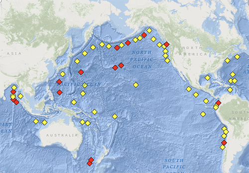
Map at Interactive map at National Data Buoy Center

Overseen by the National Oceanic and Atmospheric Administration, the buoys cost about $500,000 to install, with another $300,000 annually for upkeep. Thirty-two detection buoys dot the perimeter of the Pacific Ocean, resulting in millions of dollars per year in upkeep—costly, but vital upkeep.

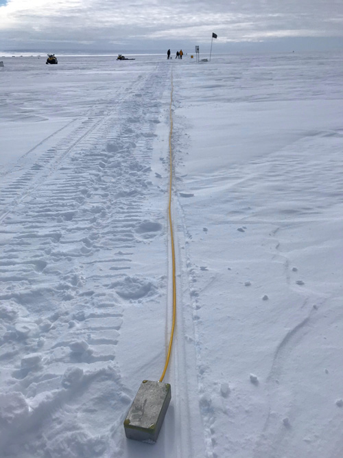
Now, U-M seismologist Zack Spica and colleagues at California Institute of Technology have used a technique called distributed acoustic sensing, or “DAS”, to tap into a cheaper, more ubiquitous way to keep tabs on the natural disasters: the roughly 1 million miles of fiber optic cables that crisscross ocean floors.

“Telecommunication companies have been laying down these fiber optic cables for the last 30 years, and have spent hundreds of billions of dollars to do that,” said Spica, U-M assistant professor of earth and environmental sciences. “Now, thanks to advanced photonics and great computing power, we can turn fiber optic cables into super dense, high fidelity arrays of sensors.”

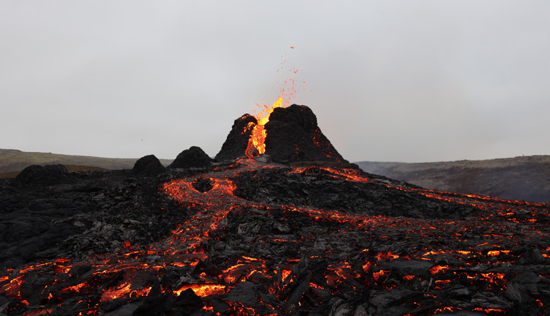
Tsunamis are a series of massive waves triggered by sudden displacement of ocean water, most typically caused by the sudden ground motion of the sea floor. Tsunamis can be minor, or they can be devastating, such as 2004’s Indian Ocean tsunami, which killed nearly 228,000 people.

In a study published in Geophysical Research Letters, Spica and colleagues show that fiber optic cables can be used as an early tsunami warning system.

“Unlike earthquakes that happen suddenly and are hardly avoidable, even though some early warning systems exist, tsunamis generally take more time to build up and reach the coast,” Spica said. “This means that early warning systems are more efficient for tsunamis. Yet, what is hard is to assess the magnitude of a tsunami before it reaches the coast. Therefore, offshore instrumentation is needed, which is costly and hard to maintain.”

Over the previous five years, Spica and his fellow researchers installed DAS interrogator units in fiber optic telecommunication companies in Alaska, Japan, Spain and Lake Ontario that tap into underwater fiber optic cables. Using one of the devices placed in Florence, Oregon, the team was able to detect a tsunami that originated in an island chain nearly 1,300 miles east of the tip of South America.

“This was a major earthquake in the Sandwich Islands that generated a large tsunami. It wasn’t even in the same ocean as the cable and device on which we detected it,” Spica said. “By the time the tsunami arrived in Oregon and Alaska, it had a run-off of only a few centimeters, which didn’t produce any damage.”

The DAS technique works by monitoring photons—particles of light—that travel through fiber optic cables. As light travels in a wave through the cables, some photons are refracted back to the beginning of the cable. These photons are refracted backward and at a given time, the amount of light that returns to the interrogator is proportional to the deformation along the cable.

Researchers initially used these cables to detect earthquakes. Earthquakes release a massive amount of energy in a very short amount of time. The big question, Spica said, was whether the cables could detect the much more subtle movement of tsunamis. The period between the crest of waves in a tsunami can be incredibly long—up to tens of minutes and several miles between the crest of waves.

“Earthquakes generally have much higher energy and shake very quickly, while tsunamis have very broad waves,” Spica said. “So the question was, can we use these techniques to monitor very long period waves?”

The researchers are unsure what characteristic of the tsunami causes a change in the fiber optic cables. Pressure-induced deformation from extra water on top of the cables could cause fibers within them to stretch, changing how photons are refracted. Temperature could cause a similar change, but Spica says more research is needed to determine exactly how the fibers are impacted.

The DAS system could offer telecommunication companies an alternate way of using fiber optic cables in the future, as satellites replace cables as a primary route of delivering internet. Spica says the cables could be used for military surveillance, boat tracking, measuring internal waves, tracking ocean temperatures and for research on climate change.

“These telecommunication companies have heard about this sensing, but it’s still very early,” Spica said. “But if we think large, if we think big over the next 15 years, they should probably try to reinvest in their own infrastructure.”

This study builds on previous research Spica conducted to determine whether fiber optics could detect ground motions from earthquakes. Next, Spica says software needs to be developed to transcribe information for tsunami detection from fiber optic cables in real time.

See the full article here .

Comments are invited and will be appreciated, especially if the reader finds any errors which I can correct. Use “Reply” at the bottom of the post.


five-ways-keep-your-child-safe-school-shootings

Please support STEM education in your local school system

Stem Education Coalition

U MIchigan Campus

The University of Michigan is a public research university located in Ann Arbor, Michigan, United States. Originally, founded in 1817 in Detroit as the “Catholepistemiad”, or “University of Michigania”, 20 years before the Michigan Territory officially became a state, the University of Michigan is the state’s oldest university. The university moved to Ann Arbor in 1837 onto 40 acres (16 ha) of what is now known as Central Campus. Since its establishment in Ann Arbor, the university campus has expanded to include more than 584 major buildings with a combined area of more than 34 million gross square feet (781 acres or 3.16 km²), and has two satellite campuses located in Flint and Dearborn. The University was one of the founding members of the Association of American Universities.

Considered one of the foremost research universities in the United States, the university has very high research activity and its comprehensive graduate program offers doctoral degrees in the humanities, social sciences, and STEM fields (Science, Technology, Engineering and Mathematics) as well as professional degrees in business, medicine, law, pharmacy, nursing, social work and dentistry. Michigan’s body of living alumni comprises more than 500,000. Besides academic life, Michigan’s athletic teams compete in Division I of the NCAA and are collectively known as the Wolverines. They are members of the Big Ten Conference.

MacArthur “genius award” winners (alumni winners and faculty winners), Nobel Prize winners, Turing Award winners, Fields Medalists and Mitchell Scholars have been affiliated with the university. Its alumni include heads of state or government, including President of the United States Gerald Ford; cabinet-level officials; and living billionaires. It also has many alumni who are Fulbright Scholars and MacArthur Fellows.

Research

Michigan is one of the founding members (in the year 1900) of the Association of American Universities. With over 6,200 faculty members, many of whom are members of the National Academy and hold an endowed chair in their discipline, the university manages one of the largest annual collegiate research budgets of any university in the United States. U-M has a technology transfer office, which is the university conduit between laboratory research and corporate commercialization interests.

In 2009, the university signed an agreement to purchase a facility formerly owned by Pfizer. The acquisition includes over 170 acres (0.69 km^2) of property, and 30 major buildings comprising roughly 1,600,000 square feet (150,000 m^2) of wet laboratory space, and 400,000 square feet (37,000 m^2) of administrative space. At the time of the agreement, the university’s intentions for the space were not set, but the expectation was that the new space would allow the university to ramp up its research and ultimately employ in excess of 2,000 people.

The university is also a major contributor to the medical field with the EKG and the gastroscope. The university’s 13,000-acre (53 km^2) biological station in the Northern Lower Peninsula of Michigan is one of only 47 Biosphere Reserves in the United States.

In the mid-1960s U-M researchers worked with IBM to develop a new virtual memory architectural model that became part of IBM’s Model 360/67 mainframe computer (the 360/67 was initially dubbed the 360/65M where the “M” stood for Michigan). The Michigan Terminal System (MTS), an early time-sharing computer operating system developed at U-M, was the first system outside of IBM to use the 360/67’s virtual memory features.

U-M is home to the National Election Studies and the University of Michigan Consumer Sentiment Index. The Correlates of War project, also located at U-M, is an accumulation of scientific knowledge about war. The university is also home to major research centers in optics, reconfigurable manufacturing systems, wireless integrated microsystems, and social sciences. The University of Michigan Transportation Research Institute and the Life Sciences Institute are located at the university. The Institute for Social Research (ISR), the nation’s longest-standing laboratory for interdisciplinary research in the social sciences, is home to the Survey Research Center, Research Center for Group Dynamics, Center for Political Studies, Population Studies Center, and Inter-Consortium for Political and Social Research. Undergraduate students are able to participate in various research projects through the Undergraduate Research Opportunity Program (UROP) as well as the UROP/Creative-Programs.

The U-M library system comprises nineteen individual libraries with twenty-four separate collections—roughly 13.3 million volumes. U-M was the original home of the JSTOR database, which contains about 750,000 digitized pages from the entire pre-1990 backfile of ten journals of history and economics, and has initiated a book digitization program in collaboration with Google. The University of Michigan Press is also a part of the U-M library system.

In the late 1960s U-M, together with Michigan State University and Wayne State University, founded the Merit Network, one of the first university computer networks. The Merit Network was then and remains today administratively hosted by U-M. Another major contribution took place in 1987 when a proposal submitted by the Merit Network together with its partners IBM, MCI, and the State of Michigan won a national competition to upgrade and expand the National Science Foundation Network (NSFNET) backbone from 56,000 to 1.5 million, and later to 45 million bits per second. In 2006, U-M joined with Michigan State University and Wayne State University to create the the University Research Corridor. This effort was undertaken to highlight the capabilities of the state’s three leading research institutions and drive the transformation of Michigan’s economy. The three universities are electronically interconnected via the Michigan LambdaRail (MiLR, pronounced ‘MY-lar’), a high-speed data network providing 10 Gbit/s connections between the three university campuses and other national and international network connection points in Chicago.

From The California Institute of Technology: “California Supervolcano is Cooling Off but May Still Cause Quakes”

Caltech Logo

From The California Institute of Technology

10.18.23
Lori Dajose

1
Credit: Caltech.

Since the 1980s, researchers have observed significant periods of unrest in a region of California’s Eastern Sierra Nevada mountains characterized by swarms of earthquakes as well as the ground inflating and rising by almost half an inch per year during these periods. The activity is concerning because the area, called the Long Valley Caldera, sits atop a massive dormant supervolcano. Seven hundred and sixty thousand years ago, the Long Valley Caldera was formed in a violent eruption that sent 650 cubic kilometers of ash into the air—a volume that could cover the entire Los Angeles area in a layer of sediment 1 kilometer thick.

2
A diagram depicting the magma chamber beneath the Long Valley Caldera. The diagram was developed from tomographic imaging using seismic waves. Credit: Biondi et al. (2023).

What is behind the increased activity in the last few decades? Could it be that the area is preparing to erupt again? Or could the uptick in activity actually be a sign that the risk of a massive eruption is decreasing?

To answer these questions, Caltech researchers have created the most detailed underground images to date of the Long Valley Caldera, reaching depths up to 10 kilometers within the Earth’s crust. These high-resolution images reveal the structure of the earth beneath the caldera and show that the recent seismic activity is a result of fluids and gases being released as the area cools off and settles down.

The work was conducted in the laboratory of Zhongwen Zhan (PhD ’14), professor of geophysics. A paper describing the research appears in the journal Science Advances [below] on October 18.

“We don’t think the region is gearing up for another supervolcanic eruption, but the cooling process may release enough gas and liquid to cause earthquakes and small eruptions,” says Zhan. “For example, in May 1980, there were four magnitude 6 earthquakes in the region alone.”

The high-resolution image shows that the volcano’s magma chamber is covered by a hardened lid of crystallized rock, formed as the liquid magma cools down and solidifies.

To create underground images, the researchers infer what the subsurface environment looks like by measuring seismic waves from earthquakes. Earthquakes generate of two types of seismic waves: primary (P-waves) and secondary (S-waves). Both kinds of waves travel at different speeds through different materials—waves are slowed down by elastic materials like liquids but travel quickly through very rigid materials like rock. Using seismometers at various locations allows one to measure discrepancies in the timing of the waves and determine the characteristics of the materials—how elastic or rigid—they traveled through. In this way, researchers can create images of the subsurface environment.

Though there are several dozen seismometers placed throughout the Eastern Sierra region, Zhan’s technique utilizes fiber optic cables (like those that provide internet) to make seismic measurements in a process called distributed acoustic sensing (DAS). The 100-kilometer stretch of cable used to image the Long Valley Caldera was comparable to a stretch of 10,000 single-component seismometers. Over a year and a half, the team used the cable to measure more than 2,000 seismic events, most too small to be felt by people. A machine learning algorithm processed those measurements and developed the resulting image.

This study is the first time that such deep, high-resolution images have been created with DAS. Previous images from local tomography studies have either been confined only to the shallow subsurface environment at depths of about 5 kilometers, or covered a larger area in lower resolution.

“This is one of the first demonstrations of how DAS can change our understanding of crustal dynamics,” says Ettore Biondi, DAS scientist at Caltech and the paper’s first author. “We’re excited to apply similar technology to other regions where we are curious about the subsurface environment.”

Next, the team plans to use a 200-kilometer length of cable to image even deeper into the Earth’s crust, to around 15 to 20 kilometers deep, where the caldera’s magma chamber—its “beating heart”—is cooling.

Science Advances

Fig. 1. Study area and local and regional events from DAS array.
3
(A) Map of the study area in which the distributed acoustic sensing (DAS) channels (green line), seismic stations (blue triangles), and earthquakes (red dots) are indicated. The black dashed line delineates the limit of the Long Valley Caldera. The white arrows point to the two events shown in the bottom panels. The red box in the map inset indicates the study area within the United States. (B and C) Strain recorded by the DAS arrays induced by local events with Northern California Earthquake Data Center (NCEDC) double-difference (DD) catalog IDs 73482516 and 73491170, respectively. The red and blue curves in these panels show the P- and S-wave neural network–picked travel times on these two events, respectively. M, Magnitude.
See the science paper for further instructive material with images.

See the full article here .

Comments are invited and will be appreciated, especially if the reader finds any errors which I can correct. Use “Reply” at the bottom of the post.


five-ways-keep-your-child-safe-school-shootings


Please help promote STEM in your local schools.

Stem Education Coalition

Caltech campus

The California Institute of Technology is a private research university in Pasadena, California. The university is known for its strength in science and engineering, and is one among a small group of institutes of technology in the United States which is primarily devoted to the instruction of pure and applied sciences.

The California Institute of Technology was founded as a preparatory and vocational school by Amos G. Throop in 1891 and began attracting influential scientists such as George Ellery Hale, Arthur Amos Noyes, and Robert Andrews Millikan in the early 20th century. The vocational and preparatory schools were disbanded and spun off in 1910 and the college assumed its present name in 1920. In 1934, The California Institute of Technology was elected to the Association of American Universities, and the antecedents of National Aeronautics and Space Administration ‘s Jet Propulsion Laboratory, which The California Institute of Technology continues to manage and operate, were established between 1936 and 1943 under Theodore von Kármán.

The California Institute of Technology has six academic divisions with strong emphasis on science and engineering. Its 124-acre (50 ha) primary campus is located approximately 11 mi (18 km) northeast of downtown Los Angeles. First-year students are required to live on campus, and 95% of undergraduates remain in the on-campus House System at The California Institute of Technology. Although The California Institute of Technology has a strong tradition of practical jokes and pranks, student life is governed by an honor code which allows faculty to assign take-home examinations. The The California Institute of Technology Beavers compete in 13 intercollegiate sports in the NCAA Division III’s Southern California Intercollegiate Athletic Conference (SCIAC).

As of October 2020, there are 76 Nobel laureates who have been affiliated with The California Institute of Technology, including 40 alumni and faculty members (41 prizes, with chemist Linus Pauling being the only individual in history to win two unshared prizes). In addition, 4 Fields Medalists and 6 Turing Award winners have been affiliated with The California Institute of Technology. There are 8 Crafoord Laureates and 56 non-emeritus faculty members (as well as many emeritus faculty members) who have been elected to one of the United States National Academies. Four Chief Scientists of the U.S. Air Force and 71 have won the United States National Medal of Science or Technology. Numerous faculty members are associated with the Howard Hughes Medical Institute as well as National Aeronautics and Space Administration. According to a 2015 Pomona College study, The California Institute of Technology ranked number one in the U.S. for the percentage of its graduates who go on to earn a PhD.

Research

The California Institute of Technology is classified among “R1: Doctoral Universities – Very High Research Activity”. Caltech was elected to The Association of American Universities in 1934 and remains a research university with “very high” research activity, primarily in STEM fields. The largest federal agencies contributing to research are National Aeronautics and Space Administration; National Science Foundation; Department of Health and Human Services; Department of Defense, and Department of Energy.

In 2005, The California Institute of Technology had 739,000 square feet (68,700 m^2) dedicated to research: 330,000 square feet (30,700 m^2) to physical sciences, 163,000 square feet (15,100 m^2) to engineering, and 160,000 square feet (14,900 m^2) to biological sciences.

In addition to managing NASA-JPL/Caltech , The California Institute of Technology also operates the Caltech Palomar Observatory; The Owens Valley Radio Observatory;the Caltech Submillimeter Observatory; the W. M. Keck Observatory at the Mauna Kea Observatory; the Laser Interferometer Gravitational-Wave Observatory at Livingston, Louisiana and Hanford, Washington; and Kerckhoff Marine Laboratory in Corona del Mar, California. The Institute launched the Kavli Nanoscience Institute at The California Institute of Technology in 2006; the Keck Institute for Space Studies in 2008; and is also the current home for the Einstein Papers Project. The Spitzer Science Center, part of the Infrared Processing and Analysis Center located on The California Institute of Technology campus, is the data analysis and community support center for NASA’s Spitzer Infrared Space Telescope [no longer in service].

Caltech Palomar Observatory. Credit: The California Institute of Technology, Altitude 1,713 m (5,620 ft), located in San Diego County, California.
California Institute of Technology The Owens Valley Radio Observatory, Owens Valley, California, Altitude 1,222 m (4,009 ft). Credit: Caltech.
Caltech’s Deep Synoptic Array-2000, or DSA-2000, an array of 2,000 radio antennas planned to be built in the Nevada desert and begin operations in 2027.
W.M. Keck Observatory two ten meter telescopes operated by California Institute of Technology and The University of California, at Mauna Kea Observatory, Hawai’i, altitude 4,207 m (13,802 ft). Credit: Caltech.
Caltech /MIT Advanced aLigo. Credit: Caltech.
Caltech/MIT Advanced aLigo Hanford, WA installation. Credit: Caltech.

Caltech/MIT Advanced aLigo detector installation Livingston, LA. Credit: Caltech.

The California Institute of Technology partnered with University of California-Los Angeles to establish a Joint Center for Translational Medicine (UCLA-Caltech JCTM), which conducts experimental research into clinical applications, including the diagnosis and treatment of diseases such as cancer.

The California Institute of Technology operates several Total Carbon Column Observing Network stations as part of an international collaborative effort of measuring greenhouse gases globally. One station is on campus.

From “Astronomy Magazine” : “Fiber optics help scientists take the pulse of our planet”

From “Astronomy Magazine”

12.22.22
Carolyn Wilke

It’s like radar but with light. Distributed acoustic sensing — DAS — picks up tremors from volcanoes and quaking ice and deep-sea faults as well as traffic rumbles and whale calls.

1
Researchers are using fiber optics to monitor vibrations — including in remote places like this site in Greenland, where a team is drilling into an ice sheet to remove a core of ice. Last summer, scientists lowered a cable 1,500 meters into the borehole and captured the rumblings produced by bedrock and ice rubbing together. Credit: Andreas Fichtner.

Andreas Fichtner strips a cable of its protective sheath, exposing a glass core thinner than a hair — a fragile, 4-kilometer-long fiber that’s about to be fused to another. It’s a fiddly task better suited to a lab, but Fichtner and his colleague Sara Klaasen are doing it atop a windy, frigid ice sheet.

After a day’s labor, they have spliced together three segments, creating a 12.5-kilometer-long cable. It will stay buried in the snow and will snoop on the activity of Grímsvötn, a dangerous, glacier-covered, Icelandic volcano.

Sitting in a hut on the ice later on, Fichtner’s team watches as seismic murmurs from the volcano beneath them flash across a computer screen: earthquakes too small to be felt but readily picked up by the optical fiber. “We could see them right under underneath our feet,” he says. “You’re sitting there and feeling the heartbeat of the volcano.”

2
Researchers Sara Klaasen and Andreas Fichtner splice optical fibers in the back of a vehicle atop an Icelandic glacier. It is tricky work for cold hands in a harsh environment. Credit: Hildur Jonsdottir.

Fichtner, a geophysicist at the Swiss Federal Institute of Technology in Zürich, is one of a cadre of researchers using fiber optics to take the pulse of our planet. Much of this work is being done in remote places, from the tops of volcanoes to the bottoms of the seas, where traditional monitoring is too costly or difficult. There, in the last five years fiber optics have started to shed light on seismic rumblings and ocean currents and even animal behaviors.

Grímsvötn’s ice sheet, for example, sits on a lake of water thawed by the volcano’s heat. Data from the new cable reveal that the floating ice field serves as a natural loudspeaker, amplifying tremors from below. The work suggests a new way to eavesdrop on the activity of volcanoes that are sheathed by ice — and so catch tremors that may herald eruptions.

Like radar but with light

The technique used by Fichtner’s team is called distributed acoustic sensing, or DAS. “It’s almost like radar in the fiber,” says physicist Giuseppe Marra of the United Kingdom’s National Physical Laboratory in Teddington, England. While radar uses reflected radio waves to locate objects DAS uses reflected light to detect events, from seismic activity to moving traffic, and to determine where they occurred.

It works like this: A laser source at one end of the fiber shoots out short pulses of light. As a pulse moves along the fiber, most of its light continues forward. But a fraction of the light’s photons bang into intrinsic flaws in the fiber — spots of abnormal density. These photons scatter, some of them traveling all the way back to the source, where a detector analyzes this reflected light for hints about what occurred along the fiber’s length.

An optical fiber for DAS typically stretches several to tens of kilometers and it moves or bends in response to disturbances in the environment. “It wiggles as cars go by, as earthquakes happen, as tectonic plates move,” says earth scientist Nate Lindsey, coauthor of a 2021 article on fiber optics for seismology in The Annual Review of Earth and Planetary Sciences [below]. Those wiggles change the reflected light signal and allow researchers to tease out information such as how an earthquake bent a cable at a certain point.

An optical cable captures vibrations, for instance, of seismic tremors along its whole length. In contrast, a typical seismic sensor, or seismometer, relays information from only one spot. And seismometers can be costly to deploy and difficult to maintain, says Lindsey, who works at a company called FiberSense that is using fiber-optic networks for applications in city settings.

2
Whether it’s under a city or on top of a remote glacier, an optical cable will wiggle when disturbed — for instance, by the motion of traffic or of seismic waves. Distributed acoustic sensing, or DAS, captures those tiny movements. Laser light pulses are sent out from the interrogator into the fiber. As they travel, some photons hit defects in the fiber, which scatters them, and some of this scattered light makes it back to the source. Analyzing this “backscattered pulse” and comparing it with the light that was originally sent out allows researchers to detect environmental events. Credit: Knowable Magazine

DAS can provide about 1 meter resolution, turning a 10-kilometer fiber into something like 10,000 sensors, Lindsey says. Researchers can sometimes piggyback off existing or decommissioned telecommunications cables. In 2018, for example, a group including Lindsey, who was then at UC Berkeley and Lawrence Berkeley National Laboratory, turned a 20-kilometer cable operated by the Monterey Bay Aquarium Research Institute — normally used to film coral, worms and whales — into a DAS sensor while the system was offline for maintenance.

“The ability to just go under the seafloor for tens of kilometers — it is remarkable that you can do that,” Lindsey says. “Historically, deploying one sensor on the seafloor can cost $10 million.”

During their four-day measurement, the team caught a 3.4-magnitude earthquake shaking the ground some 30 kilometers away in Gilroy, California. For Lindsey’s team, it was a lucky strike. Earth scientists can use seismic signals from earthquakes to get a sense of the structure of the ground that the quake has traveled through, and the signals from the fiber-optic cable allowed the team to identify several previously unknown submarine faults [Science (below)]. “We’re using that energy to basically illuminate this structure of the San Andreas Fault,” Lindsey says.

Eavesdropping on cities and cetaceans

DAS was pioneered by the oil and gas industry to monitor wells and detect gas in boreholes, but researchers have been finding a variety of other uses for the technique. In addition to earthquakes, it has been harnessed to monitor traffic and construction noise in cities [Geophysical Research Letters (below)]. In densely populated metropolises with significant seismic hazards, such as Istanbul, DAS could help to map the sediments and rocks in the subsurface to reveal which areas would be the most dangerous during a large quake, Fichtner says. A recent study even reported eavesdropping on whale songs using a seabed optical cable near Norway [Frontiers in Marine Science (below)].

Cutting a trench for fiber-optic cable.
Fichtner’s team buried their fiber-optic cable on Grímsvötn. In this video, they are trenching the first few hundred meters with a chainsaw because this part of the caldera rim is too steep for their snow-grooming vehicle. Credit: Andreas Fichtner.

But DAS comes with some limitations. It’s tricky to get good data from fibers longer than 100 kilometers. The same flaws in the cables that make light scatter — producing the reflected light that is measured — can deplete the signal from the source. With enough distance traveled, the original pulse would be completely lost.

But a newer, related method may provide an answer — and perhaps allow researchers to spy on a mostly unmonitored seafloor, using existing cables that shuttle the data of billions of emails and streaming binges.

In 2016, Marra’s team sought a way to compare the timekeeping of ultraprecise atomic clocks at distant spots around Europe. Satellite communications are too slow for this job, so the researchers turned to buried optical cables instead. At first, it didn’t work: Environmental disturbances introduced too much noise into the messages that the team sent along the cables. But the scientists sensed an opportunity. “That noise that we want to get rid of actually contains very interesting information,” Marra says.

3
On a glacier above Iceland’s Grímsvötn volcano, Andreas Fichtner and Sara Klaasen unroll a spool of fiber-optic cable. They will eventually lay down some 12 kilometers of the cable for distributed acoustic sensing. Credit: Kristin Jonsdottir.

Using state-of-the-art methods for measuring the frequency of light waves bouncing along the fiber-optic cable, Marra and colleagues examined the noise and found that — like DAS — their technique detected events like earthquakes through changes in the light frequencies.

Instead of pulses, though, they use a continuous beam of laser light. And unlike in DAS, the laser light travels out and back on a loop; then the researchers compare the light that comes back with what they sent out. When there are no disturbances in the cable, those two signals are the same. But if heat or vibrations in the environment disturb the cable, the frequency of the light shifts.

With its research-grade light source and measurement of a large amount of the light initially emitted — as opposed to just what’s reflected — this approach works over longer distances than DAS does. In 2018, Marra’s team demonstrated that they could detect quakes with undersea and underground fiber-optic cables up to 535 kilometers long [Science (below)], far exceeding DAS’s limit of around 100 kilometers.

This offers a way to monitor the deep ocean and Earth systems that are usually hard to reach and rarely tracked using traditional sensors. A cable running close to the epicenter of an offshore earthquake could improve on land-based seismic measurements, providing perhaps minutes more time for people to prepare for a tsunami and make decisions, Marra says. And the ability to sense changes in seafloor pressure may open the door to directly detecting tsunamis too.

On Grímsvötn, a research team prepares to deploy a cable onto a floating ice field on the volcano’s caldera. Data from that cable have revealed that the ice field acts as a loudspeaker, amplifying seismic tremors from below. Credit: Andreas Fichtner.

In late 2021, Marra’s team managed to sense seismicity across the Atlantic on a 5,860-kilometer optical cable running on the seafloor between Halifax in Canada and Southport in England. And they did so with far greater resolution than before, because while earlier measurements relied on accumulated signals from across the entire submarine cable’s length, this work parsed changes in light from roughly 90-kilometer spans between signal-amplifying repeaters.

Fluctuations in intensity of the signal picked up on the transatlantic cable appear to be tidal currents [Science (below)]. “These are essentially the cable being strummed as a guitar string as the currents go up and down,” Marra says. While it’s easy to watch currents at the surface, seafloor observations can improve an understanding of ocean circulation and its role in global climate, he adds.

So far, Marra’s team is alone in using this method. They’re working on making it easier to deploy and on providing more accessible light sources.

Researchers are continuing to push sensing techniques based on optical fibers to new frontiers. Earlier this year, Fichtner and a colleague journeyed to Greenland, where the East Greenland Ice-Core Project is drilling a deep borehole into the ice sheet to remove an ice core. Fichtner’s team then lowered a fiber-optic cable 1,500 meters, by hand — and caught a cascade of icequakes, rumbles that result from the bedrock and ice sheet rubbing together.

Icequakes can deform ice sheets and contribute to their flow toward the sea. But researchers haven’t had a way before now to investigate how they happen: They are invisible at the surface. Perhaps fiber optics will finally bring their hidden processes into the light.

Science papers:

Science 2018
Science
Geophysical Research Letters 2020
Frontiers in Marine Science
See the above science paper for instructive material with images.

Science article:
The Annual Review of Earth and Planetary Sciences 2021
See the science article for instructive material with images.

See the full article here .

Comments are invited and will be appreciated, especially if the reader finds any errors which I can correct. Use “Reply”.


five-ways-keep-your-child-safe-school-shootings

Please help promote STEM in your local schools.

Stem Education Coalition

Astronomy is a magazine about the science and hobby of Astronomy. Based near Milwaukee in Waukesha, Wisconsin, it is produced by Kalmbach Publishing. Astronomy’s readers include those interested in astronomy and those who want to know about sky events, observing techniques, astrophotography, and amateur astronomy in general.

Astronomy was founded in 1973 by Stephen A. Walther, a graduate of The University of Wisconsin–Stevens Point and amateur astronomer. The first issue, August 1973, consisted of 48 pages with five feature articles and information about what to see in the sky that month. Issues contained astrophotos and illustrations created by astronomical artists. Walther had worked part time as a planetarium lecturer at The University of Wisconsin–Milwaukee and developed an interest in photographing constellations at an early age. Although even in childhood he was interested to obsession in Astronomy, he did so poorly in mathematics that his mother despaired that he would ever be able to earn a living. However, he graduated in Journalism from the University of Wisconsin Stevens Point, and as a senior class project he created a business plan for a magazine for amateur astronomers. With the help of his brother David, he was able to bring the magazine to fruition. He died in 1977.

From The University of Washington : “New UW Photonic Sensing Facility will use fiber-optic cables for seismic sensing and glaciology and more”

From The University of Washington

8.17.22
Kiyomi Taguchi
Hannah Hickey

Here’s how fiber optic cables are used to sense ground movement.
Watch: Researchers Brad Lipovsky and Marine Denolle explain how fiber-optic cables can be used to sense ground motion. Credit: Kiyomi Taguchi/UW.

The fiber-optic cables that travel underground, along the seafloor and into our homes have potential besides transmitting videos, emails and tweets. These signals can also record ground vibrations as small as a nanometer anywhere the cable touches the ground. This unintended use for fiber-optic cables was discovered decades ago and has had limited use in military and commercial applications.

A University of Washington pilot project is exploring the use of fiber-optic sensing for seismology, glaciology, and even urban monitoring. Funded in part with a $473,000 grant from the M.J. Murdock Charitable Trust, a nonprofit based in Vancouver, Washington, the new UW Photonic Sensing Facility has three decoder machines, or “interrogators,” that use photons traveling through a fiber-optic cable to detect ground motions as small as 1 nanometer.

“Fiber-optic sensing is the biggest advance in ground-based geophysics since the field went digital in the 1970s,” said principal investigator Brad Lipovsky, a UW assistant professor of Earth and space sciences. “The UW Photonic Sensing Facility and its partners will explore this technology’s potential across scientific fields — including seismology, glaciology, oceanography and monitoring hydrology and infrastructure.”

The new center — the largest in the United States and the first of its kind in the Pacific Northwest — is among a handful of research hubs around the world that are beginning to explore fiber optics for sensing ground motion. This approach to monitoring could expand the amount of seismic data by thousands of times.

2
The “interrogator” device is a portable box, about the size of a toaster, that turns optical signals into very precise ground motions. The UW Photonic Sensing Facility has three interrogators that can be used in labs or in the field. Each one collects as much data as 15,000 seismometers.Febus

For now, one of the three UW interrogator machines is hooked up to a “dark fiber,” or unused cable, that runs between the UW campuses in Seattle and Bothell. The researchers will soon also connect to a similar underwater cable across Alaska’s Cook Inlet to sense volcanic, oceanic, glacial and tectonic systems there. The other equipment will be used for temporary deployments.

When the ground vibrates — due to a heavy truck, construction work, or an earthquake — the seismic waves travel out from the source like ripples on a pond. When a seismic wave reaches the fiber-optic cable, the cable stretches very slightly, and that disrupts photons that are naturally reflected back to the source. The researchers can detect this disruption in the returning light waves and determine where the cable was disturbed.

The technique is known as “distributed acoustic sensing,” or DAS, because the system is spread out and can be used to monitor both sound waves and ground motion.

The same technology can also record more gradual motions. Lipovsky, who studies glaciers, and UW graduate student John-Morgan Manos carried equipment up to Easton Glacier on Mount Baker to monitor the rate of surface melt. The team installed a cable and used an interrogator to see how much snow was melting on the glacier.

In other pilot projects, UW researchers with the Pacific Northwest Seismic Network are exploring uses for seismology, including earthquakes, volcanoes and landslides. UW oceanographers will use fiber-optic cables connecting to a seafloor observatory to monitor ocean faults and even eavesdrop on whales. UW civil engineers will study whether this technology could monitor traffic collisions or building and bridge infrastructure.

The facility will include semi-permanent observatories in Seattle and other unused “dark” fibers, including a cable that runs to Whidbey Island. The team also plans to lay cables for temporary field deployments at Mt. Rainier and is exploring projects farther afield at a fjord in Greenland and at McMurdo Station in Antarctica.

3
A fiber-optic cable (yellow) on the surface of the Rhone Glacier in Switzerland during a collaborative project that included Brad Lipovsky. The UW Photonic Sensing Facility has already used similar equipment at Easton Glacier on Mt. Baker.Swiss Federal Institute of Technology in Zürich.

“We’re getting to the ‘smart Earth’ concept, where we can listen to the Earth,” said Marine Denolle, a UW assistant professor of Earth and space sciences. “This technology allows seismic sensing to go to places you could not go before — where it was too hard, or too expensive, to deploy sensors. The other aspect that’s new is a density of sensors beyond what we had before.”

Today’s seismometers record ground motion at a single point, whereas fiber-optic cables take measurements at many points along the cable — the test cable has 15,000 data channels. Denolle will use computing and machine learning to make sense of this new mountain of seismic data.

“In seismology, our data used to be just wiggles,” Denolle said. “This is the first time we can get 2D images, and even videos, of data streaming in.”

The M.J. Murdock Charitable Trust grant was awarded in late 2021. Researchers have used the funds to hook up and test the equipment last spring, and a data-visualization room on campus is coming soon.

“Thanks to the M.J. Murdock Charitable Trust’s support, the UW is the first university to acquire so much equipment for this technique,” Lipovsky said. “This is in the pilot experiment stage, and we are excited to see where it goes.”

See the full article here .


five-ways-keep-your-child-safe-school-shootings

Please help promote STEM in your local schools.
Stem Education Coalition

u-washington-campus

The University of Washington is one of the world’s preeminent public universities. Our impact on individuals, on our region, and on the world is profound — whether we are launching young people into a boundless future or confronting the grand challenges of our time through undaunted research and scholarship. Ranked number 10 in the world in Shanghai Jiao Tong University rankings and educating more than 54,000 students annually, our students and faculty work together to turn ideas into impact and in the process transform lives and our world. For more about our impact on the world, every day.

So what defines us —the students, faculty and community members at the University of Washington? Above all, it’s our belief in possibility and our unshakable optimism. It’s a connection to others, both near and far. It’s a hunger that pushes us to tackle challenges and pursue progress. It’s the conviction that together we can create a world of good. Join us on the journey.

The University of Washington is a public research university in Seattle, Washington, United States. Founded in 1861, University of Washington is one of the oldest universities on the West Coast; it was established in downtown Seattle approximately a decade after the city’s founding to aid its economic development. Today, the university’s 703-acre main Seattle campus is in the University District above the Montlake Cut, within the urban Puget Sound region of the Pacific Northwest. The university has additional campuses in Tacoma and Bothell. Overall, University of Washington encompasses over 500 buildings and over 20 million gross square footage of space, including one of the largest library systems in the world with more than 26 university libraries, as well as the UW Tower, lecture halls, art centers, museums, laboratories, stadiums, and conference centers. The university offers bachelor’s, master’s, and doctoral degrees through 140 departments in various colleges and schools, sees a total student enrollment of roughly 46,000 annually, and functions on a quarter system.

University of Washington is a member of the Association of American Universities and is classified among “R1: Doctoral Universities – Very high research activity”. According to the National Science Foundation, UW spent $1.41 billion on research and development in 2018, ranking it 5th in the nation. As the flagship institution of the six public universities in Washington state, it is known for its medical, engineering and scientific research as well as its highly competitive computer science and engineering programs. Additionally, University of Washington continues to benefit from its deep historic ties and major collaborations with numerous technology giants in the region, such as Amazon, Boeing, Nintendo, and particularly Microsoft. Paul G. Allen, Bill Gates and others spent significant time at Washington computer labs for a startup venture before founding Microsoft and other ventures. The University of Washington’s 22 varsity sports teams are also highly competitive, competing as the Huskies in the Pac-12 Conference of the NCAA Division I, representing the United States at the Olympic Games, and other major competitions.

The university has been affiliated with many notable alumni and faculty, including 21 Nobel Prize laureates and numerous Pulitzer Prize winners, Fulbright Scholars, Rhodes Scholars and Marshall Scholars.

In 1854, territorial governor Isaac Stevens recommended the establishment of a university in the Washington Territory. Prominent Seattle-area residents, including Methodist preacher Daniel Bagley, saw this as a chance to add to the city’s potential and prestige. Bagley learned of a law that allowed United States territories to sell land to raise money in support of public schools. At the time, Arthur A. Denny, one of the founders of Seattle and a member of the territorial legislature, aimed to increase the city’s importance by moving the territory’s capital from Olympia to Seattle. However, Bagley eventually convinced Denny that the establishment of a university would assist more in the development of Seattle’s economy. Two universities were initially chartered, but later the decision was repealed in favor of a single university in Lewis County provided that locally donated land was available. When no site emerged, Denny successfully petitioned the legislature to reconsider Seattle as a location in 1858.

In 1861, scouting began for an appropriate 10 acres (4 ha) site in Seattle to serve as a new university campus. Arthur and Mary Denny donated eight acres, while fellow pioneers Edward Lander, and Charlie and Mary Terry, donated two acres on Denny’s Knoll in downtown Seattle. More specifically, this tract was bounded by 4th Avenue to the west, 6th Avenue to the east, Union Street to the north, and Seneca Streets to the south.

John Pike, for whom Pike Street is named, was the university’s architect and builder. It was opened on November 4, 1861, as the Territorial University of Washington. The legislature passed articles incorporating the University, and establishing its Board of Regents in 1862. The school initially struggled, closing three times: in 1863 for low enrollment, and again in 1867 and 1876 due to funds shortage. University of Washington awarded its first graduate Clara Antoinette McCarty Wilt in 1876, with a bachelor’s degree in science.

19th century relocation

By the time Washington state entered the Union in 1889, both Seattle and the University had grown substantially. University of Washington’s total undergraduate enrollment increased from 30 to nearly 300 students, and the campus’s relative isolation in downtown Seattle faced encroaching development. A special legislative committee, headed by University of Washington graduate Edmond Meany, was created to find a new campus to better serve the growing student population and faculty. The committee eventually selected a site on the northeast of downtown Seattle called Union Bay, which was the land of the Duwamish, and the legislature appropriated funds for its purchase and construction. In 1895, the University relocated to the new campus by moving into the newly built Denny Hall. The University Regents tried and failed to sell the old campus, eventually settling with leasing the area. This would later become one of the University’s most valuable pieces of real estate in modern-day Seattle, generating millions in annual revenue with what is now called the Metropolitan Tract. The original Territorial University building was torn down in 1908, and its former site now houses the Fairmont Olympic Hotel.

The sole-surviving remnants of Washington’s first building are four 24-foot (7.3 m), white, hand-fluted cedar, Ionic columns. They were salvaged by Edmond S. Meany, one of the University’s first graduates and former head of its history department. Meany and his colleague, Dean Herbert T. Condon, dubbed the columns as “Loyalty,” “Industry,” “Faith”, and “Efficiency”, or “LIFE.” The columns now stand in the Sylvan Grove Theater.

20th century expansion

Organizers of the 1909 Alaska-Yukon-Pacific Exposition eyed the still largely undeveloped campus as a prime setting for their world’s fair. They came to an agreement with Washington’s Board of Regents that allowed them to use the campus grounds for the exposition, surrounding today’s Drumheller Fountain facing towards Mount Rainier. In exchange, organizers agreed Washington would take over the campus and its development after the fair’s conclusion. This arrangement led to a detailed site plan and several new buildings, prepared in part by John Charles Olmsted. The plan was later incorporated into the overall University of Washington campus master plan, permanently affecting the campus layout.

Both World Wars brought the military to campus, with certain facilities temporarily lent to the federal government. In spite of this, subsequent post-war periods were times of dramatic growth for the University. The period between the wars saw a significant expansion of the upper campus. Construction of the Liberal Arts Quadrangle, known to students as “The Quad,” began in 1916 and continued to 1939. The University’s architectural centerpiece, Suzzallo Library, was built in 1926 and expanded in 1935.

After World War II, further growth came with the G.I. Bill. Among the most important developments of this period was the opening of the School of Medicine in 1946, which is now consistently ranked as the top medical school in the United States. It would eventually lead to the University of Washington Medical Center, ranked by U.S. News and World Report as one of the top ten hospitals in the nation.

In 1942, all persons of Japanese ancestry in the Seattle area were forced into inland internment camps as part of Executive Order 9066 following the attack on Pearl Harbor. During this difficult time, university president Lee Paul Sieg took an active and sympathetic leadership role in advocating for and facilitating the transfer of Japanese American students to universities and colleges away from the Pacific Coast to help them avoid the mass incarceration. Nevertheless, many Japanese American students and “soon-to-be” graduates were unable to transfer successfully in the short time window or receive diplomas before being incarcerated. It was only many years later that they would be recognized for their accomplishments during the University of Washington’s Long Journey Home ceremonial event that was held in May 2008.

From 1958 to 1973, the University of Washington saw a tremendous growth in student enrollment, its faculties and operating budget, and also its prestige under the leadership of Charles Odegaard. University of Washington student enrollment had more than doubled to 34,000 as the baby boom generation came of age. However, this era was also marked by high levels of student activism, as was the case at many American universities. Much of the unrest focused around civil rights and opposition to the Vietnam War. In response to anti-Vietnam War protests by the late 1960s, the University Safety and Security Division became the University of Washington Police Department.

Odegaard instituted a vision of building a “community of scholars”, convincing the Washington State legislatures to increase investment in the University. Washington senators, such as Henry M. Jackson and Warren G. Magnuson, also used their political clout to gather research funds for the University of Washington. The results included an increase in the operating budget from $37 million in 1958 to over $400 million in 1973, solidifying University of Washington as a top recipient of federal research funds in the United States. The establishment of technology giants such as Microsoft, Boeing and Amazon in the local area also proved to be highly influential in the University of Washington’s fortunes, not only improving graduate prospects but also helping to attract millions of dollars in university and research funding through its distinguished faculty and extensive alumni network.

21st century

In 1990, the University of Washington opened its additional campuses in Bothell and Tacoma. Although originally intended for students who have already completed two years of higher education, both schools have since become four-year universities with the authority to grant degrees. The first freshman classes at these campuses started in fall 2006. Today both Bothell and Tacoma also offer a selection of master’s degree programs.

In 2012, the University began exploring plans and governmental approval to expand the main Seattle campus, including significant increases in student housing, teaching facilities for the growing student body and faculty, as well as expanded public transit options. The University of Washington light rail station was completed in March 2015, connecting Seattle’s Capitol Hill neighborhood to the University of Washington Husky Stadium within five minutes of rail travel time. It offers a previously unavailable option of transportation into and out of the campus, designed specifically to reduce dependence on private vehicles, bicycles and local King County buses.

University of Washington has been listed as a “Public Ivy” in Greene’s Guides since 2001, and is an elected member of the American Association of Universities. Among the faculty by 2012, there have been 151 members of American Association for the Advancement of Science, 68 members of the National Academy of Sciences, 67 members of the American Academy of Arts and Sciences, 53 members of the National Academy of Medicine, 29 winners of the Presidential Early Career Award for Scientists and Engineers, 21 members of the National Academy of Engineering, 15 Howard Hughes Medical Institute Investigators, 15 MacArthur Fellows, 9 winners of the Gairdner Foundation International Award, 5 winners of the National Medal of Science, 7 Nobel Prize laureates, 5 winners of Albert Lasker Award for Clinical Medical Research, 4 members of the American Philosophical Society, 2 winners of the National Book Award, 2 winners of the National Medal of Arts, 2 Pulitzer Prize winners, 1 winner of the Fields Medal, and 1 member of the National Academy of Public Administration. Among UW students by 2012, there were 136 Fulbright Scholars, 35 Rhodes Scholars, 7 Marshall Scholars and 4 Gates Cambridge Scholars. UW is recognized as a top producer of Fulbright Scholars, ranking 2nd in the US in 2017.

The Academic Ranking of World Universities (ARWU) has consistently ranked University of Washington as one of the top 20 universities worldwide every year since its first release. In 2019, University of Washington ranked 14th worldwide out of 500 by the ARWU, 26th worldwide out of 981 in the Times Higher Education World University Rankings, and 28th worldwide out of 101 in the Times World Reputation Rankings. Meanwhile, QS World University Rankings ranked it 68th worldwide, out of over 900.

U.S. News & World Report ranked University of Washington 8th out of nearly 1,500 universities worldwide for 2021, with University of Washington’s undergraduate program tied for 58th among 389 national universities in the U.S. and tied for 19th among 209 public universities.

In 2019, it ranked 10th among the universities around the world by SCImago Institutions Rankings. In 2017, the Leiden Ranking, which focuses on science and the impact of scientific publications among the world’s 500 major universities, ranked University of Washington 12th globally and 5th in the U.S.

In 2019, Kiplinger Magazine’s review of “top college values” named University of Washington 5th for in-state students and 10th for out-of-state students among U.S. public colleges, and 84th overall out of 500 schools. In the Washington Monthly National University Rankings University of Washington was ranked 15th domestically in 2018, based on its contribution to the public good as measured by social mobility, research, and promoting public service.

From Eos: “The Big Data Revolution Unlocks New Opportunities for Seismology”

Eos news bloc

From Eos

AT

AGU

9 June 2022

Stephen J. Arrowsmith
sarrowsmith@smu.edu
Daniel T. Trugman

Karianne Bergen
Beatrice Magnani

1
A recent experiment that used over 50,000 seismic nodes achieved the densest seismic survey on land. These photographs show nodes being staged, transported by truck, and charged/harvested in racks. Credit: Ourabah and Crosby [2020]

Scientists have been measuring earthquakes for hundreds of years. As instruments have advanced, so has our understanding of how and why the ground moves. A recent article published in Reviews of Geophysics describes how the “Big Data” revolution is now advancing the field of seismology. We asked some of the authors to explain how seismic waves are measured, how measurement techniques have changed over time, and how big data is being collected and used to advance science.

In simple terms, what is seismology and why is it important?

Seismology is a science that is based on vibrational waves (‘seismic waves’) that travel through the Earth. Seismic waves produce ground motions that are recorded by seismometers. Recorded ground motions can provide vital clues both about the sources of waves (e.g., earthquakes, volcanoes, explosions, etc.) and about the properties of the Earth the waves travel through. Seismology provides tools for understanding the physics of earthquakes, for monitoring natural hazards, and for revealing the internal structure of the Earth.

How does a seismometer work and what important advancements in knowledge have been made since their development?

It’s surprisingly hard to accurately measure the motion of the ground because any instrument that does so must also move with the ground (otherwise it would have to be in the air, where it couldn’t directly record ground motion). To deal with this challenge, seismometers contain a mass on a spring that remains stationary (an ‘inertial mass’), and they measure the motion of the instrument relative to that mass. Early seismometers were entirely mechanical, but it’s hard to design a mechanical system where the inertial mass stays still over a range of frequencies of ground motion.

A key advancement was the use of electronics to keep the mass fixed and therefore record a much wider range of frequencies. An ideal seismometer can record accurately over a broad band of frequencies and a wide range of ground motion amplitudes without going off scale. This is easier said than done, but seismometers are improving every year.

What is the difference between passive and exploration seismology?

Passive seismology is about recording the seismic waves generated by natural or existing sources like earthquakes. Passive seismologists typically deploy instruments for a long time in order to gather the data they need from the spontaneous occurrence of natural sources of seismic waves. In contrast, exploration seismologists generate their own seismic waves using anthropogenic sources like explosions, air guns, or truck vibrations. Because they control the timing and location of the source of seismic waves, exploration seismologists typically work with large numbers of instruments that are deployed for a short time. Exploration seismology is most widely used in the oil industry but can also be used for more general scientific purposes when high resolution imaging is needed.

How have advances in seismologic methods improved subsurface imaging?

Developments in seismic imaging techniques are allowing seismologists to significantly improve the resolution of images of the subsurface. A particularly powerful technique for high resolution imaging is called Full-Waveform Inversion (FWI). FWI uses the full seismogram for imaging, trying to match data and model “wiggle for wiggle” rather than only using simplified measures like travel times, and can thus provide better image resolution. The method has become widely adopted by the exploration seismology community for this reason and is now becoming more common in the passive seismic community as well.

Another important innovation in imaging uses persistent sources of ambient noise like ocean waves to image the subsurface. This is particularly useful for short-term deployments where there is often insufficient time to wait around for natural sources like earthquakes to occur.

What is “Big Data” and how is it being used in seismology?

“Big Data” is a relative term that defines data containing greater variety, with larger volumes or coming in at a faster rate, which requires different data analysis methods and technologies than “small data”. In seismology the volumes of data being acquired from individual experiments are now reaching hundreds of terabytes in passive seismology, and petabytes in exploration seismology. For perspective, a typical laptop has less than one terabyte of disk storage. The velocity of data is the rate at which it is acquired or analyzed. In seismology, a new measurement technique called Distributed Acoustic Sensing (DAS) can fill a 1 terabyte hard drive in approximately 14 hours. The variety of data being used for seismic investigations is also increasing, with complementary data types like GNSS, barometric pressure, and infrasound becoming more commonly combined with seismic data.

What are the main drivers of Big Data Seismology?

There are three main drivers. First, innovations in sensing systems are allowing seismologists to conduct ‘big data’ experiments. Second, new data-hungry algorithms such as machine learning and deep neural networks are enabling seismologists to scale up their data analysis and extract more meaning from massive seismic datasets. Third, advances in computing are allowing seismologists to apply data-hungry algorithms to big data experiments. Parallel and distributed computing allow scientists to perform many computations simultaneously, with calculations often split across multiple machines, and cloud computing services provide researchers with access to on-demand computing power.

Moving forward, what are some of the challenges and opportunities that Big Data seismologists face?

In terms of challenges, the first relates to handling large amounts of data. Most seismologists are accustomed to easily accessing and sharing data via web services, with most of their processing and analysis of the data done on their own computers. This workflow and the infrastructure that supports it doesn’t scale well for Big Data Seismology. Another challenge is obtaining the skills that it takes to do research with big seismic datasets, which requires expertise not only in seismology but also in statistics and computer science. Skills in statistics and computer science are not routinely part of most Earth Science curricula, but they’re becoming increasingly important in order to do research at the cutting edge of Big Data Seismology.

The opportunities are wide-ranging, and our paper discusses many opportunities for fundamental science discovery in detail, but it’s also hard to anticipate all the discoveries that will be made possible. Our best guide is to look back at the history of seismology, where many major discoveries have been driven by advances in data. For instance, the discovery of the layers of Earth followed the development of seismometers that were sufficiently sensitive to measure teleseismic earthquakes. The discovery of the global pattern of seismicity – which played a key part in the development of the theory of plate tectonics – was preceded by the development of the first global seismic network. The first digital global seismic network was followed by our first images of the convecting mantle. If we take the past as our guide, we can anticipate that the era of Big Data Seismology will provide the foundation for creative seismologists to make new discoveries.

See the full article here .

five-ways-keep-your-child-safe-school-shootings

Please help promote STEM in your local schools.

Stem Education Coalition

Eos is the leading source for trustworthy news and perspectives about the Earth and space sciences and their impact. Its namesake is Eos, the Greek goddess of the dawn, who represents the light shed on understanding our planet and its environment in space by the Earth and space sciences.

From Eos: “Chasing Magma Around Iceland’s Reykjanes Peninsula”

From AGU
Eos news bloc

From Eos

25 May 2021
Alka Tripathy-Lang

1
Icelandic Meteorological Office seismologist Kristín Jónsdóttir stands on solidified black basalt that glows red from erupting Fagradalsfjall behind her. Credit: Kristín Jónsdóttir.

In December 2019 Reykjanes Peninsula which juts into the Atlantic Ocean southwest of Iceland’s capital city of Reykjavík began experiencing intense seismic swarms. Since then, scientists at the Icelandic Meteorological Office have been tracking and monitoring deformation of Earth’s surface as magma pushed (intruded) itself into the shallow crust. Three initial intrusions occurred near Mount Thorbjörn, just outside the town of Grindavík. A fourth intrusion slightly inflated the peninsula’s westernmost tip, and a fifth intrusion leapfrogged back east, beyond Grindavík, to Krýsuvík, according to Sara Barsotti, an Italian volcanologist and coordinator for volcanic hazards at the Icelandic Meteorological Office.

2
Reykjanes Peninsula in southwestern Iceland experienced thousands of earthquakes associated with subterranean magma intrusions in early 2021. The earliest quakes were identified near Mount Thorbjörn and Krýsuvík. The largest earthquake (M5.7) jolted the peninsula between Keilir and Fagradalsfjall. (Keflavik International Airport and the Icelandic capital of Reykjavík are shown for scale.) Fagradalsfjall soon became Iceland’s newest active volcano. Credit: Google Earth.

More than a year after this unrest began on 24 February, a large earthquake measuring magnitude 5.7 jolted the peninsula between Keilir and Fagradalsfjall “marking a turning point,” Barsotti said.

Soon thereafter the Icelandic Meteorological Office’s seismic network recorded more than 50,000 earthquakes on the peninsula. Using the monitoring tools at their disposal, scientists found a corridor of magma between Keilir and Fagradalsfjall, said Barsotti. This magma flowed underground for approximately 3 weeks, with earthquakes defining the edges of the subterranean chamber. Then, both seismicity and deformation plummeted.

At that point, some scientists hypothesized that the intrusion would freeze within the crust, said Kristín Jónsdóttir, a seismologist at the Icelandic Meteorological Office. “Then,” she said, “the eruption started.”

3
Against a gray sky, orange lava pours and pops out of Fagradalsfjall on the second day of the eruption. In the foreground, cooling lava glows against the black basalt that’s already solidified. Credit: Toby Elliott/Unsplash.

Keeping Crowds Safe

On 19 March lava began to erupt from the edge of the intrusion near Fagradalsfjall and Icelanders flocked to the mountains above the fissure to picnic; play football; or simply observe nature’s lava light show. “Icelanders…feel this is part of their life,” said Barsotti. “They really want to enjoy what their country is capable [of giving] them.”

Because crowds continue to visit the eruption, the Icelandic Meteorological Office meets daily with Iceland’s Department of Civil Protection and Emergency Management to ensure the safety of volcano watchers, Barsotti explained. A rescue team is always present, and they use handheld sensors to detect gases that could be dangerous.

“The big challenge,” Barsotti said, is “[foreseeing] the opening of new vents.” What began as a single vent now boasts eight craters in a row. “People should be [able] to go, but [we must keep] them far away from what we consider to be hazardous.”

The Icelandic Meteorological Office keeps vigil over this volcano with a variety of techniques. For example, InSAR (interferometric synthetic aperture radar), a satellite-based method, allows scientists to measure differences in topography at centimeter scale. GPS stations help track how the ground itself moves. Passive satellite imagery helps track the progress of toxic clouds, like sulfur dioxide.

Seismic Monitoring of the Future

Geoscientists from across Europe have been exploring distributed acoustic sensing, or DAS, to monitor seismicity near Mount Thorbjörn. In April, Sebastian Heimann, a scientist at Helmholtz Centre Potsdam (DE), in Germany, presented the latest results from the ongoing study at the 2021 Annual Meeting of the Seismological Society of America.

At a molecular level, DAS works because fiber-optic cables contain impurities, explained Hanna Blanck, one of Heimann’s coauthors and a doctoral student at the University of Iceland. By sending a laser pulse through a cable, the light will encounter these impurities, she said. When that happens, the light scatters, and a small portion returns toward the laser source. By continuously measuring the returning signal, scientists can look for changes that indicate the cable has moved. Earthquakes have distinct signatures that help differentiate them from, for example, the rumble of a passing car.

DAS provides several advantages to traditional seismic networks, including higher spatial resolution, said Blanck. Traditional seismic networks are spaced kilometers apart, whereas the spatial resolution Heimann used along the 21-kilometer-long cable was a scant 4 meters.

“We caught more small earthquakes compared to the conventional methods [likely because] we have many more records along the fiber,”said Philippe Jousset, a coauthor and geophysicist at Helmholtz Centre, describing previous work using the same cable near Mount Thorbjörn. In that study, Jousset and his colleagues, including Blanck, compared the catalog of earthquakes recorded by both DAS and traditional seismic stations.

“Propagating magma increases the pressure in the surrounding crust, causing many small earthquakes,” said Blanck. More data mean detecting more small earthquakes, which should yield a better picture of magma movement.

However, “[DAS] is still in its research phase,” said Jónsdóttir, “so it’s not being routinely used by monitoring agencies.” In the future, she said, it will likely complement more established methods in seismology.

Nevertheless, seismologists and volcanologists often investigate secrets of Earth that cannot be seen, Jónsdóttir said, so holding a freshly formed piece of basalt as lava spews in the background—after hypothesizing the existence of an intrusion in that very location—provides incredible validation.

See the full article here .

five-ways-keep-your-child-safe-school-shootings

Please help promote STEM in your local schools.

Stem Education Coalition

Eos is the leading source for trustworthy news and perspectives about the Earth and space sciences and their impact. Its namesake is Eos, the Greek goddess of the dawn, who represents the light shed on understanding our planet and its environment in space by the Earth and space sciences.

From Seismological Society of America (US) : “Fiber Optic Cable Monitors Microseismicity in Antarctica”

From Seismological Society of America (US)

23 April 2021

At the Seismological Society of America’s 2021 Annual Meeting, researchers shared how they are using fiber optic cable to detect the small earthquakes that occur in ice in Antarctica.

The results could be used to better understand the movement and deformation of the ice under changing climate conditions, as well as improve future monitoring of carbon capture and storage projects, said Anna Stork, a geophysicist at Silixa Ltd.

Stork discussed how she and her colleagues are refining their methods of distributed acoustic sensing, or DAS, for microseismicity—earthquakes too small to be felt. DAS works by using the tiny internal flaws within an optical fiber as thousands of seismic sensors. An instrument at one end sends laser pulses down the cable and measures the “echo” of each pulse as it is reflected off the fiber’s internal flaws.

1
Building a DAS system in Antarctica. | Michael Kendall.

When the fiber is disturbed by earthquakes or icequakes, there are changes in the size, frequency and phase of laser light scattered back to the DAS receiver that can be used characterize the seismic event.

Michael Kendall of the University of Oxford (UK) said the Antarctic research demonstrates how DAS can be used to monitor underground carbon capture and storage at other sites in the world. For instance, the layout of the Antarctic network offers a good example for how a similar network could be configured to best detect microseismicity that could be triggered by carbon storage.

“Our work also demonstrates a method of using DAS fiber arrays to investigate microseismic earthquake source mechanisms in more detail than conventional geophones,” said Tom Hudson of the University of Oxford. “If we can analyze the source mechanism—how an earthquake fails or fractures—then we may be able to attribute the earthquake to the movement of fluids like carbon dioxide in a reservoir.”

The Antarctic microseismic icequakes recorded by DAS “are approximately magnitude -1, corresponding to approximately the size of a book falling off a table,” Hudson explained, “so they are very small earthquakes.”

The study by Hudson and colleagues is the first to use DAS to look at icequakes in Antarctica. The fiber optic cable was deployed in a linear and triangular configuration on the ice surface at the Rutford Ice Stream.

Kendall said there are a number of challenges to using fiber optic sensors in the harsh Antarctica environment. The equipment had to travel in pieces by boat and several planes to the study site. The researchers had to bury the fiber to reduce wind noise contaminating the seismic signal, as well as remove the signal of a generator that powered the DAS instrument.

“We housed the instrument in a mountaineering tent, which basically served as a tiny office,” Stork explained. “Keeping temperatures within the recommended operating limits was a challenge. The radiative heating from the sun warned the tent to well in the 30s [degrees Celsius], even though it was -10 degrees Celsius outside.”

The researchers share their analyses of icequake data with climatologists and other researchers studying the slip of glaciers and other ice movements in Antarctica, Kendall said.

“Hopefully in the future we will interact more with scientists drilling ice cores too, as they use fiber as distributed temperature sensors, but these fibers that they put down boreholes could also be used for seismic studies like ours,” he noted.

See the full article here.

five-ways-keep-your-child-safe-school-shootings

Please help promote STEM in your local schools.

Stem Education Coalition

The Seismological Society of America (US) is an international scientific society devoted to the advancement of seismology and the understanding of earthquakes for the benefit of society. Founded in 1906, the society has members throughout the world representing seismologists and other geophysicists, geologists, engineers, insurers, and policy-makers in preparedness and safety.

The society was established by academic, government, and other scientific and engineering professionals in the months following the April 18th San Francisco earthquake, with the first meeting of the Board of Directors taking place on December 1, 1906.

The Seismological Society of America publishes the Bulletin of the Seismological Society of America (BSSA), a journal of research in earthquake seismology and related disciplines since 1911, and Seismological Research Letters (SRL), which serves as a forum for informal communication among seismologists, as well as between seismologists and those non-specialists interested in seismology and related disciplines.

From LBNL: “Dark Fiber: Using Sensors Beneath Our Feet to Tell Us About Earthquakes, Water, and Other Geophysical Phenomenon”

Berkeley Logo

Berkeley Lab

December 5, 2017
Julie Chao
JHChao@lbl.gov
(510) 486-6491

Berkeley Lab researchers successfully use distributed acoustic sensing for seismic monitoring.

1
(from left) Shan Dou, Jonathan Ajo-Franklin, and Nate Lindsey were on a Berkeley Lab team that used fiber optic cables for detecting earthquakes and other subsurface activity. (Credit: Marilyn Chung/Berkeley Lab)

Scientists at the Department of Energy’s Lawrence Berkeley National Laboratory (Berkeley Lab) have shown for the first time that dark fiber – the vast network of unused fiber-optic cables installed throughout the country and the world – can be used as sensors for detecting earthquakes, the presence of groundwater, changes in permafrost conditions, and a variety of other subsurface activity.

In a pair of recently published papers, a team led by Berkeley Lab researcher Jonathan Ajo-Franklin announced they had successfully combined a technology called “distributed acoustic sensing,” which measures seismic waves using fiber-optic cables, with novel processing techniques to allow reliable seismic monitoring, achieving results comparable to what conventional seismometers can measure.

“This has huge potential because you can just imagine long stretches of fibers being turned into a massive seismic network,” said Shan Dou, a Berkeley Lab postdoctoral fellow. “The idea is that by using fiber that can be buried underground for a long time, we can transform traffic noise or other ambient vibrations into usable seismic signals that can help us to monitor near-surface changes such as permafrost thaw and groundwater-level fluctuations.”

Dou is the lead author of Distributed Acoustic Sensing for Seismic Monitoring of the Near Surface: A Traffic-Noise Interferometry Case Study, which was published in September in Nature’s Scientific Reports and verified the technique for monitoring the Earth’s near surface. More recently, Ajo-Franklin’s group published a follow-up study led by UC Berkeley graduate student Nate Lindsey, Fiber-Optic Network Observations of Earthquake Wavefields, in Geophysical Research Letters (GRL), which demonstrates the viability of using fiber-optic cables for earthquake detection.

What is dark fiber?

Dark fiber refers to unused fiber-optic cable, of which there is a glut thanks to a huge rush to install the cable in the early 1990s by telecommunications companies. Just as the cables were buried underground, the technology for transmitting data improved significantly so that fewer cables were needed. There are now dense corridors of dark fiber crisscrossing the entire country.

Distributed acoustic sensing (DAS) is a novel technology that measures seismic wavefields by shooting short laser pulses across the length of the fiber. “The basic idea is, the laser light gets scattered by tiny impurities in the fiber,” said Ajo-Franklin. “When fiber is deformed, we will see distortions in the backscattered light, and from these distortions, we can measure how the fiber itself is being squeezed or pulled.”

3
Jonathan Ajo-Franklin (left) installing an experimental fiber optic test array at the Richmond Field Station. (Courtesy Jonathan Ajo-Franklin)

Using a test array they installed in Richmond, California – with fiber-optic cable placed in a shallow L-shaped trench, one leg of about 100 meters parallel to the road and another perpendicular – the researchers verified that they could use seismic waves generated by urban traffic, such as cars and trains, to image and monitor the mechanical properties of shallow soil layers.

The measurements give information on how “squishy” the soil is at any given point, making it possible to infer a great deal of information about the soil properties, such as its water content or texture. “Imagine a slinky – it can compress or wiggle,” Ajo-Franklin said. “Those correspond to different ways you can squeeze the soil, and how much energy it takes to reduce its volume or shear it.”

He added: “The neat thing about it is that you’re making measurements across each little unit of fiber. All the reflections come back to you. By knowing all of them and knowing how long it takes for a laser light to travel back and forth on the fiber you can back out what’s happening at each location. So it’s a truly distributed measurement.”

Having proven the concept under controlled conditions, the team said they expect the technique to work on a variety of existing telecommunications networks, and they are currently conducting follow-up experiments across California to demonstrate this. Ongoing research in Alaska is also exploring the same technique for monitoring the stability of Arctic permafrost.

Added Dou: “We can monitor the near surface really well by using nothing but traffic noise. It could be fluctuations in groundwater levels, or changes that could provide early warnings for a variety of geohazards such as permafrost thaw, sinkhole formation, and landslides.”

Using fiber for quake detection

3
Nate Lindsey trims cable at the Richmond Field Station (Courtesy Jonathan Ajo-Franklin)

Building on five years of Berkeley Lab-led research exploring the use of DAS for subsurface monitoring using non-earthquake seismic sources, Ajo-Franklin’s group has now pushed the envelope and has shown that DAS is a powerful tool for earthquake monitoring as well.

In the GRL study led by Lindsey in collaboration with Stanford graduate student Eileen Martin, the research team took measurements using the DAS technique on fiber-optic arrays in three locations – two in California and one in Alaska. In all cases, DAS proved to be comparably sensitive to earthquakes as conventional seismometers, despite its higher noise levels. Using the DAS arrays, they assembled a catalog of local, regional, and distant earthquakes and showed that processing techniques could take advantage of DAS’ many channels to help understand where earthquakes originate from.

Ajo-Franklin said that dark fiber has the advantage of being nearly ubiquitous, whereas traditional seismometers, because they are expensive, are sparsely installed, and subsea installations are particularly scarce. Additionally, fiber allows for dense spatial sampling, meaning data points are only meters apart, whereas seismometers typically are separated by many kilometers.

Lindsey added: “Fiber has a lot of implications for earthquake detection, location, and early warning. Fiber goes out in the ocean, and it’s all over the land, so this technology increases the likelihood that a sensor is near the rupture when an earthquake happens, which translates into finding small events, improved earthquake locations, and extra time for early warning.”

The GRL paper notes other potential applications of using the dark fiber, including urban seismic hazard analysis, global seismic imaging, offshore submarine volcano detection, nuclear explosion monitoring, and microearthquake characterization.

The research was funded by the Department of Defense through the Strategic Environmental Research and Development Program as well as by Laboratory Directed Research and Development funding.

Other co-authors on the GRL paper are Barry Freifeld of Berkeley Lab, Douglas Dreger of UC Berkeley, Martin and Biondo Biondi of Stanford University, Steve Cole of OptaSense Inc., and Stephanie James of Sandia National Laboratories. Lindsey is supported by a National Science Foundation Graduate Research Fellowship. Other co-authors of the Scientific Reports paper are Freifeld, Thomas Daley, Michelle Robertson, John Peterson, and Craig Ulrich of Berkeley Lab; Anna Wagner of the U.S. Army Cold Regions Research & Engineering Laboratory; and Martin.

See the full article here .

Please help promote STEM in your local schools.

STEM Icon

Stem Education Coalition

A U.S. Department of Energy National Laboratory Operated by the University of California

University of California Seal

DOE Seal