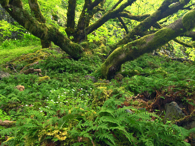
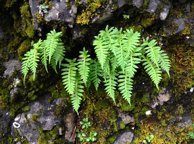
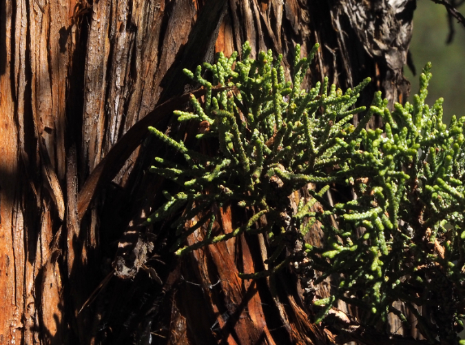
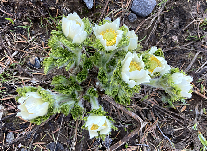
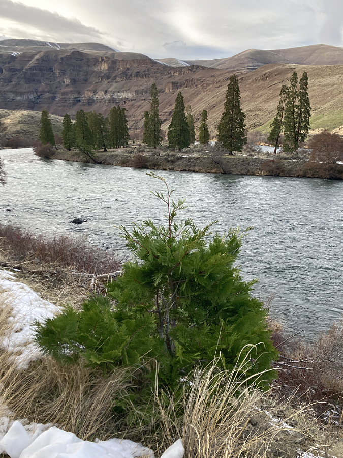
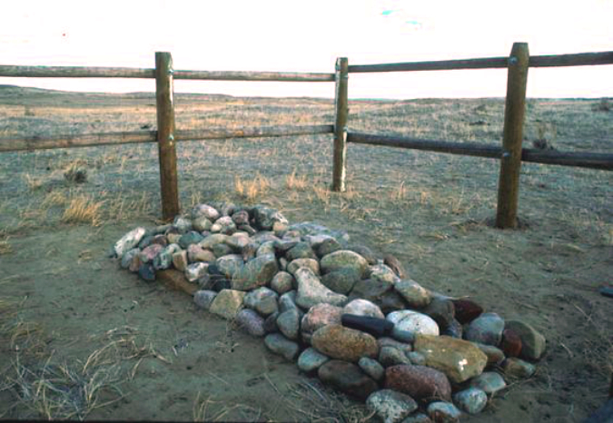
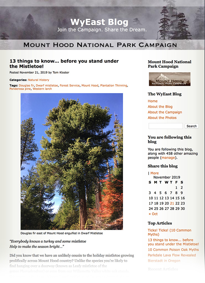
Licorice fern in their two favorite habitats – growing on moss-covered talus (foreground) and on the moss-covered trunks of a sprawling Bigleaf Maple in the Columbia River Gorge
One of the great heroes of our Pacific Northwest forests is so ubiquitous that it’s almost always hiding in plain sight. Licorice Fern (Polypodium glycyrrhiza) is a creeping fern species whose rhizomes cling to moss-covered surfaces – typically tree trunks and rocks. The many ferns around the world that belong to the Polypodium genus share the growth habit of sprouting fronds from creeping roots called rhizomes, reflecting the genus name Polypodium, which translates to “many footed”.
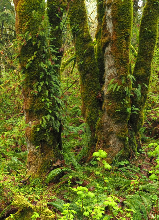
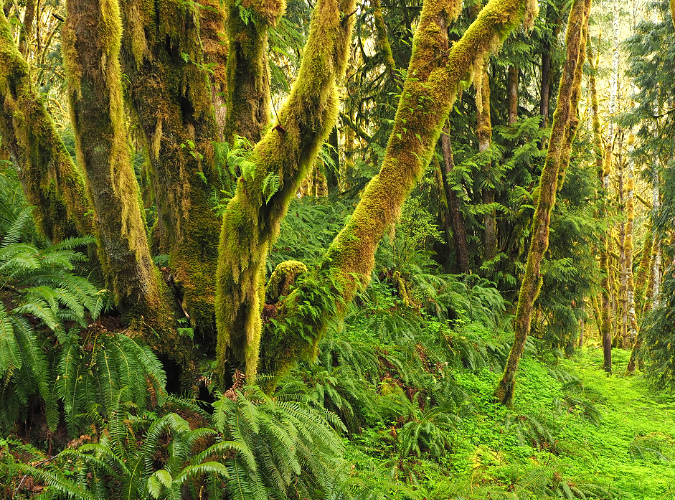
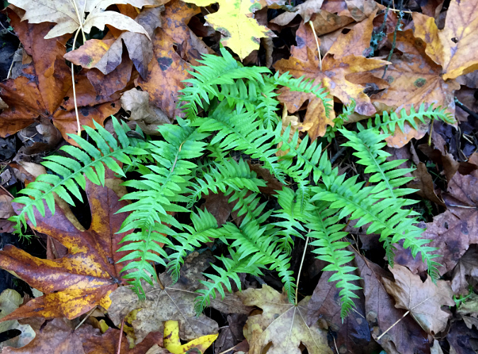
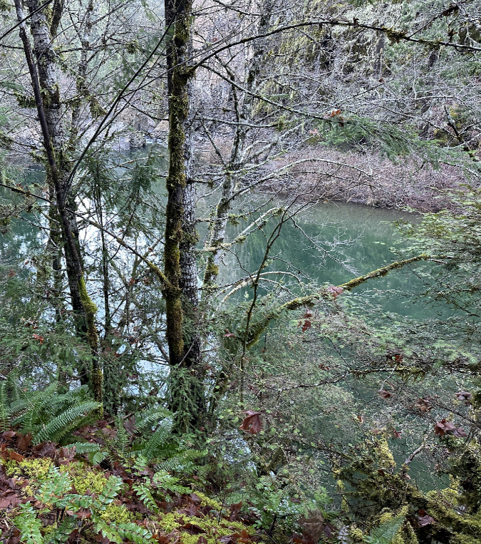
Licorice Fern on a grove of rainforest Bigleaf Maple and Red Alder along the Molalla River
While many of its cousins have especially furry “feet” to protect their rhizomes as they creep across bare surfaces, Licorice Fern has adapted to our rainforests by creeping under thick layers of moss. This not only protects their rhizomes, it also allows for more consistent access to moisture, given that these plants almost exclusively grow where there is no soil – just on rock surfaces or across tree bark.
Like their cousins, Licorice Fern still retain enough of these fine hairs and roots on their rhizomes to anchor themselves as they grow to the underlying rock or tree bark under that protective blanket of moss.
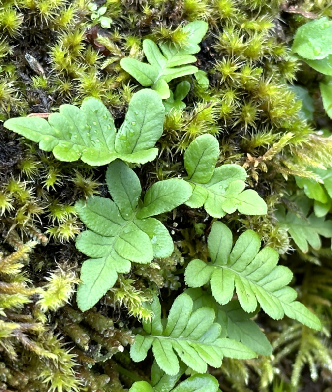
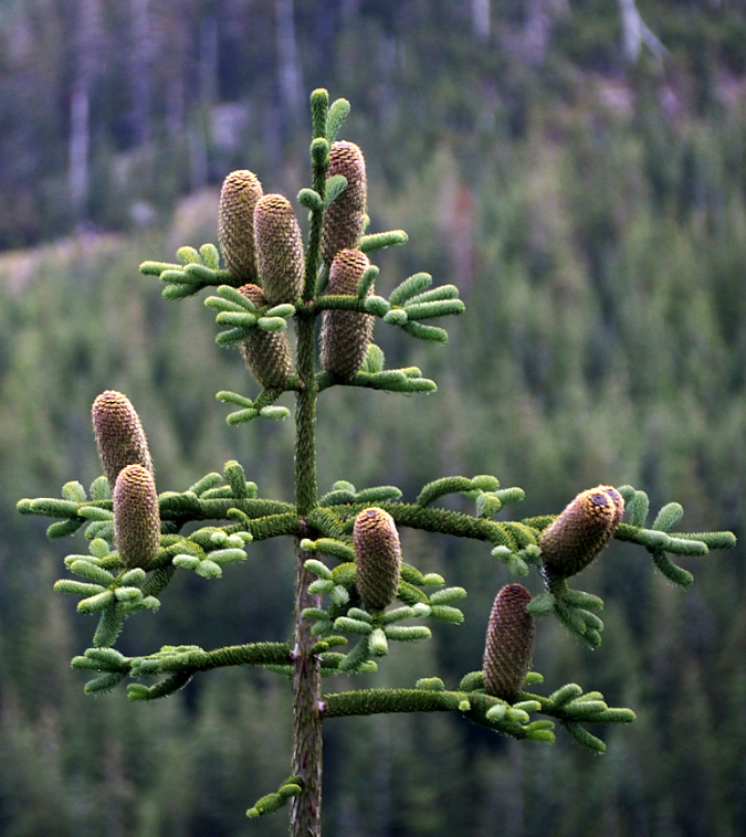
The anatomy and reproductive phases of a Licorice Fern
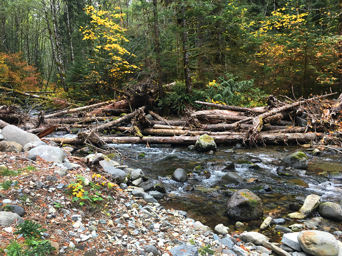
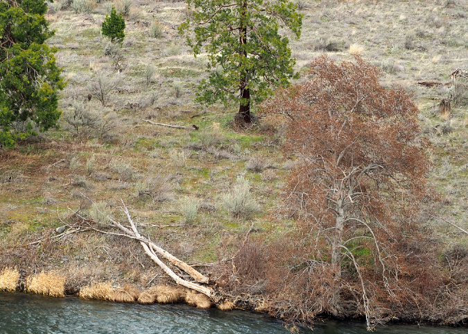
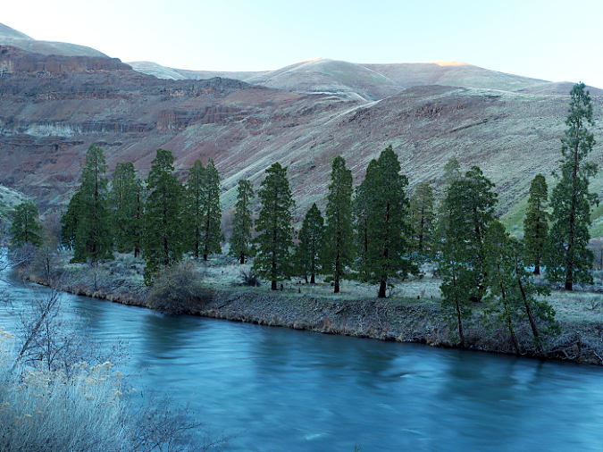
Licorice Fern have colonized these massive boulders along Moffett Creek where a layer of moss is enough for the ferns to take hold
The second part of their Latin name – glycyrrhiza – translates to “sweet root” and describes the licorice flavor of their rhizomes that give these ferns their common name. If you grew up in the forests of the Pacific Northwest, you probably learned as a kid to identify both Licorice Fern and Wild Ginger (another, less common plant with a strongly flavored underground stem) for their distinct flavors. Both are important first foods for indigenous people and continue to draw interest in the broader foraging community today.
Northwest indigenous peoples chewed Licorice Fern rhizomes for their flavor and as a medicine for colds and coughs, or cooked as a prepared food (which removes an enzyme in the rhizomes that can otherwise deplete Vitamin B). If you’re curious, you don’t have to destroy a Licorice Fern to sample its flavor (or better yet, to introduce kids to the plant). Carefully peel back the moss from the edge of patch of ferns to reveal the rhizomes and snap off a small piece to chew like gum.
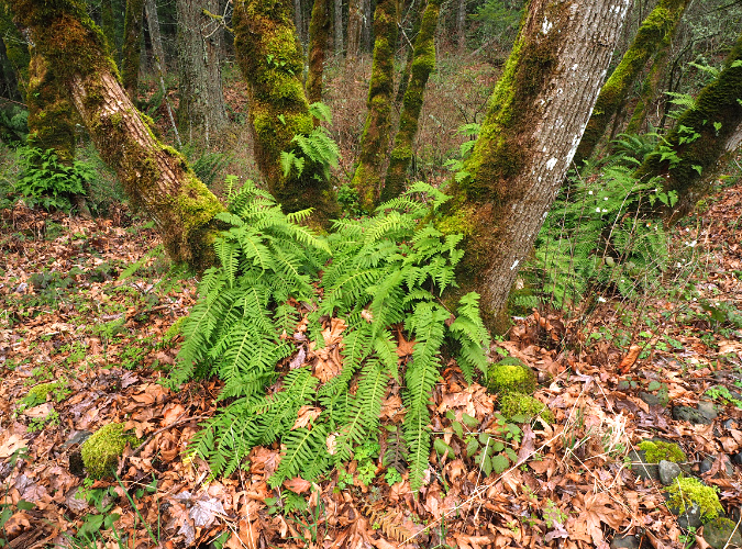
A new colony of Licorice Fern is working its way up this very large Bigleaf Maple along the Molalla River
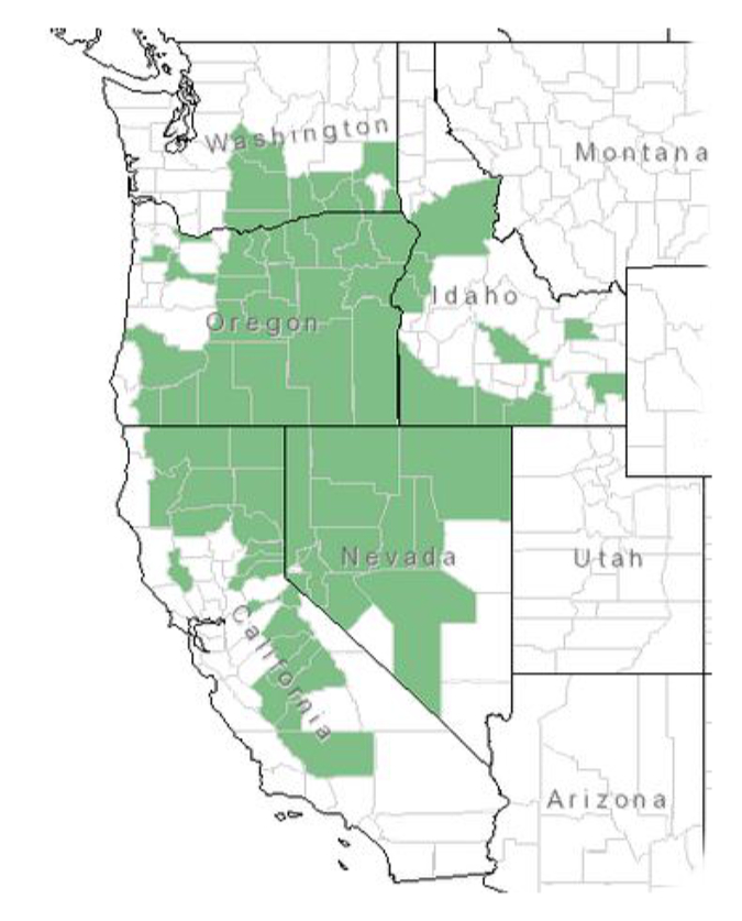
Their specialized adaptation to our moss-covered forests also explains their range. Licorice Fern are onlyfound in along the temperate Pacific Coast, from the Alaska Panhandle south to the Redwood forests of Northern California (an odd exception is a small population found in the Idaho panhandle). Within this narrow band, it is a remarkably adaptable species, in part because of its unusual growth cycle – more about that later in the article.
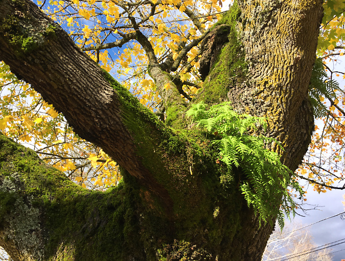
Their ability to grow without soil and cling to surfaces with their rhizomes makes Licorice Fern amazingly versatile and acrobatic in its native habitat. These ferns will happily grow upside down if there’s moss and moisture to be found on a cliff overhang, just as they can be found fifty feet (or more) from the forest floor, thriving on the trunk of an old-growth Bigleaf Maple or Red Alder, their most favored tree hosts.
Licorice Fern thrive where limbs come together on large trees like this Bigleaf Maple, where the moss is abundant and rainwater concentrates between storms
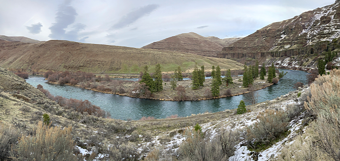
Fern heaven in a mixed rainforest of Bigleaf Maple, Red Alder and Western Redcedar near the Clackamas. Sword Fern carpet the forest flloor beneath the giant Bigleaf Maple on the left, while Licorice Fern scale its mossy limbs
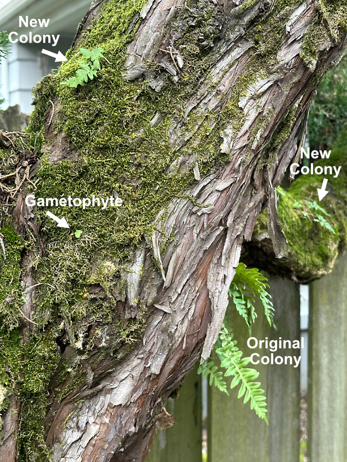
Licorice ferns spread by both creeping with their “feet” and – like all ferns – by their spores. There is plenty of evidence of both forms of spreading and reproducing if you look closely in our forests.
When creeping by their feet, their progression up a tree trunk or across a moss-covered boulder is obvious. But when you see a smaller, isolated patch high up in a tree, or alone on a boulder, it is likely a new colony is forming from spores that took hold from a nearby parent colony.
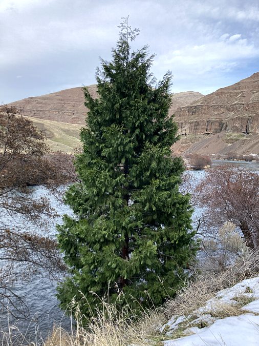
Licorice Fern growing nearly 70 feet in the air on these Bigleaf Maples along Latourell Creek
This vertical rock face along Tanner Creek has only a thin layer of moss, but it faces north and is thus protected from summer heat, allowing several Licorice Fern to become established here
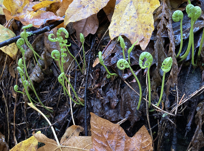
You’re not likely to notice Licorice Fern during its “gametophyte” phase – the transitional state in non-flowering plants that reproduce by spores by which a new fern is born. However, if you look closely where Licorice Fern grow, you might spot juvenile ferns that have recently emerged from the gametophyte phase with tiny, developing fronds.
Airborne spores allowed Licorice Fern to colonize this giant boulder in the middle of Silver Creek
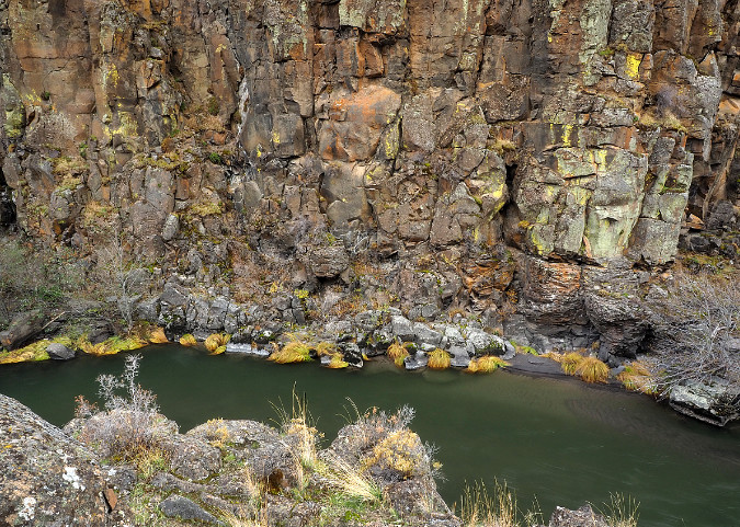
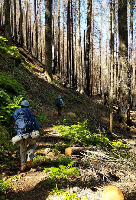
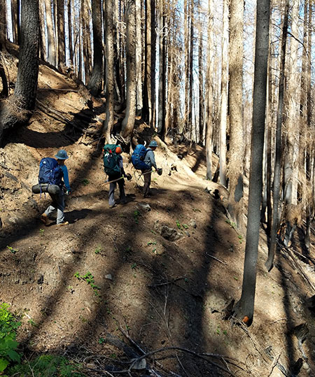
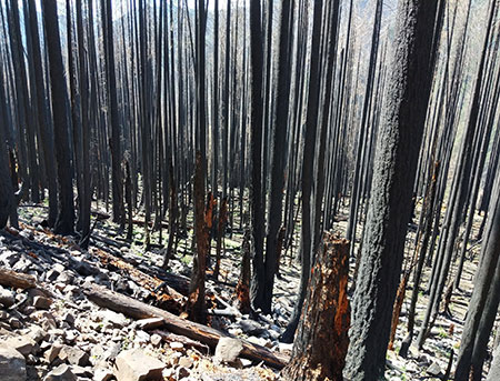
The importance of their ability to reproduce by spores is on full display right now where our rainforests have recently experienced major wildfires – most notably, the Columbia River Gorge. Unlike many understory plants whose roots were protected from scorching heat by a layer of soil, Licorice Fern were decimated by the fires – along with the moss layers they anchor themselves in.
As the burned areas gradually recover in places like the Gorge, mosses are quickly beginning to take hold on talus slopes and burned trees. Licorice Ferns will soon follow as their spores find their way to moss layers that have grown sufficiently thick.
These cliff-dwelling Licorice Fern grow under a moist ledge on a north-facing cliff in the Gorge. This allowed them to escape the recent fire, and they will now send spores to the surrounding, burned area as it recovers from the burn
Licorice Fern spores are tiny and can travel long distances in the air, so one patch of surviving ferns in a burned area can quickly spread to form new fern colonies once the moss has returned and gametophytes can survive.
The scene below shows a talus slope in the Gorge that was covered with a thick blanket of moss and Licorice Fern before the 2017 Eagle Creek Fire, and now must rely on spores from survivors like this small colony to restore the fern population.
The small colony in the foreground somehow escaped the heat during the Gorge fire and now will help restore the much larger colony across this slope the moss recovery continues
One of the remarkable stories in the unfolding forest recovery after the fire is how pioneer species like Licorice Fern begin to move back to areas they once dominated. Before the fire, it would have been easy to simply see these plants are pretty additions to the mossy landscape.
Yet, in areas where the fire completely burned away the moss and fern layer on the talus slopes that define the Gorge, we now know the important role they play in helping hold these over-steepened slopes together. In places where moss and fern-covered talus had not moved for decades, the loss of this thin, living blanket has triggered countless rock slides that continue to plague trail restoration in the Gorge. In time, the moss and Licorice Fern partnership will once again return to these slopes and – barring another fire in the near term – help stabilize them, once again.
The unusual life cycle of a Licorice Fern
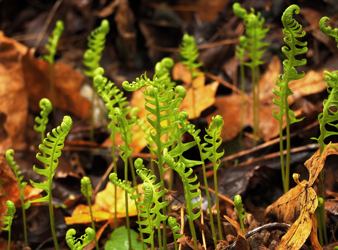
Licorice Fern in peak foliage… in mid-winter?
Licorice Fern are so familiar in our forests that most consider them to be perennial – like Sword Fern or Deer Fern – keeping their foliage year-round. And sometimes they are, but just as these plants can scale their foliage to local conditions, Licorice Fern are uniquely adapted to buck the conventional annual growth seasons that most plants follow, whereby new growth appears in spring and summer, followed by a dormant cycle in fall and winter.
I used to see Licorice Fern in late summer or fall looking yellowed and wilted, and assumed these plants were doing what a lot of broadleaf species do, and simply sacrificing some foliage in the face of our annual summer drought. This was based on seeing other Licorice Fern soldier through the dry spells where they were growing in more protected spots.
Licorice Fern fronds browning out in mid-summer in the Columbia River Gorge
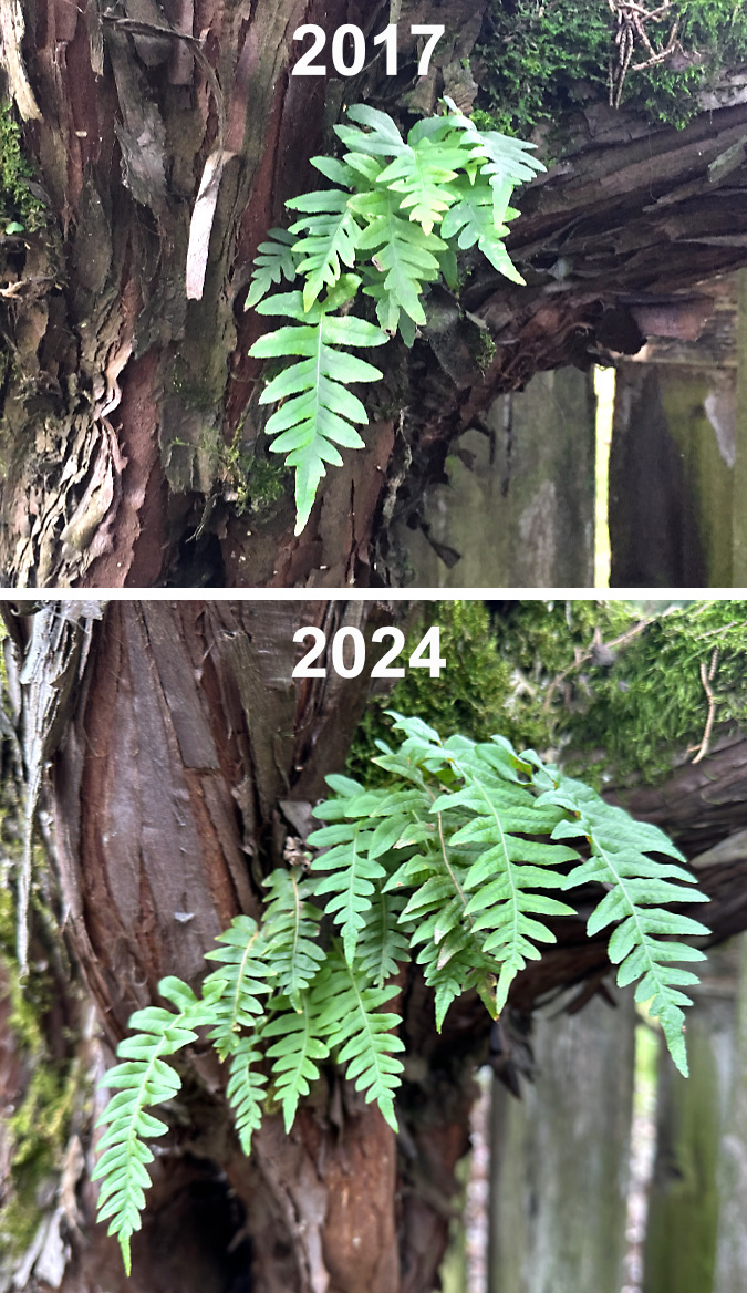
Then I noticed something surprising on a late October visit to the Gorge several years ago: thousands tiny Licorice Fern fronds were unrolling from the moss layer on trees and rocks that had been rejuvenated by the first big rains and cooler temperatures of the fall season.
Researching this, I discovered that Licorice Fern often grow their annual burst of new foliage in the fall, not spring – and keep this foliage at least until the next summer drought, or until new fronds appear in the fall in places where they are more protected or have summer moisture.
Tiny new Licorice Fern fronds just beginning to emerge from drought-dormant rhizomes at Starvation Creek in mid-October
Young Licorice Fern fronds rising above the fall leaf litter near Starvation Creek in early November
Just one month into their re-emergence in late fall, this colony of Licorice Fern near Starvation Creek has produced a dense new flush of fronds that will mature to dark green and remain over winter and into the next summer drought
This upended growth cycle makes sense for a hardy fern that grows on the soil-less surfaces of trees and rocks, and thus more reliant on regular rainfall. Their thick rhizomes contain enough stored moisture to help them ride through short dry spells, but when long summer droughts hit our forests, these ferns have adapted to simply drop their foliage and go dormant until the rains reappear.
Their inverted growth calendar also explains why Licorice Fern favor deciduous host trees like Bigleaf Maple and Red Alder. Not only do these trees typically provide the thick moss layers that the ferns require, they lose their leaves in late fall and winter, when the ferns are growing and need access to light the most. While you will often see Licorice Fern in evergreen forests, their preferred environment is on deciduous trees or mossy rocks and logs in an open forest settings for this reason.
New Licorice Fern fronds emerging in fall from a moss-covered rock buried in new leaf debris – a common scene where these plants grow on rocks or logs in open forest
Licorice Fern also have the ability to scale their foliage to their microclimate, further expanding their adaptability. Plants in consistently cool, moist and shaded locations become quite lush, with fronds up to a foot long that persist year-round, even during summer droughts. This is why Licorice Fern appear as evergreens in rainforests on the wet west side of the Cascades.
This lush Licorice Fern colony in the Gorge grows at the protected base of a Bigleaf Maple and on adjacent moss-covered rocks – the best of both worlds for these ferns
In exposed locations where the moss layer is less thick, or they face extended summer droughts and very cold winters, Licorice Fern adapt by downsizing their foliage to minimize moisture loss and maximize the period in which they are leafed out each year. These locations include talus slopes and exposed cliffs throughout their range, or where they grow in shaded areas at the edge their range, east of the Cascades.
In these harsh environments they typically have short, rounded fronds, sometimes just an inch or two long, and often survive by shedding their downsized foliage in early summer and going dormant for the next 4-5 months.
The tiny new fronds on these licorice ferns are as large as they will get on this protected boulder in an Oregon White Oak grove in the otherwise arid east Columbia River Gorge
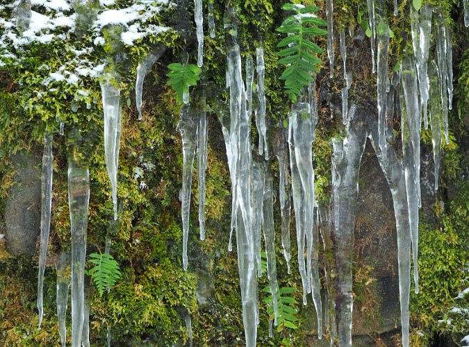
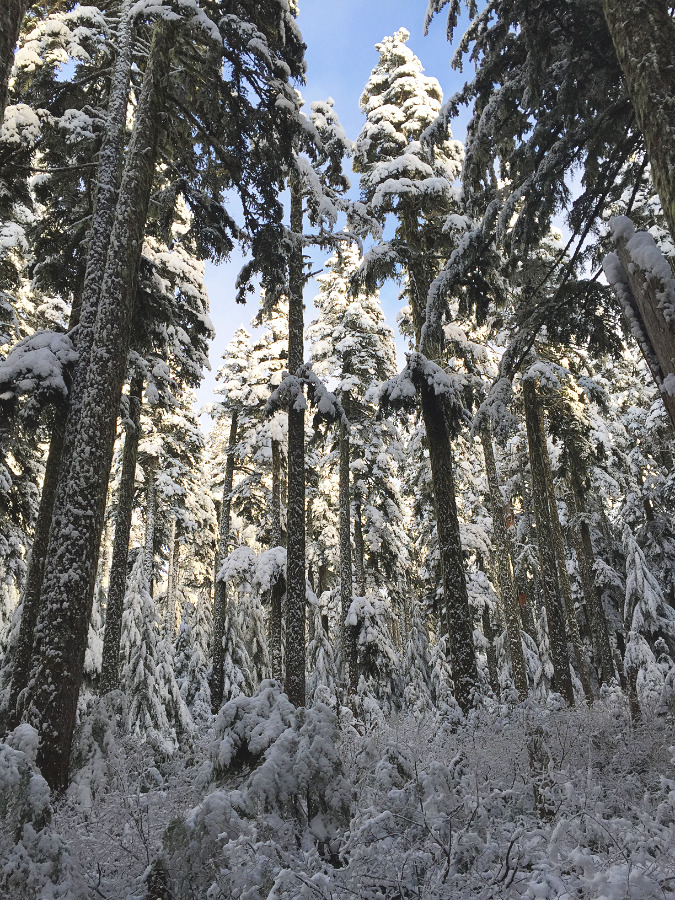
Their inverse growth cycle requires Licorice Fern to be especially hardy in winter, when tender new foliage is leafing out just as freezing temperatures arrive across most of their range. These plants are especially well-adapted to snow and ice, as can be seen every winter in the Columbia River Gorge, where winter weather conditions are especially severe. While a heavy snowfall or ice storm can level other ferns, Licorice Fern quickly bounce back and continue their upside-down growth cycle throughout winter.
Cliff-dwelling Licorice Fern typically downsize their foliage, both to preserve moisture in these exposed locations and to withstand tough winter weather conditions
Short, flexible fronds allow Licorice Fern to be completely buried in snow and ice, then emerge and spring back, ready to continue their winter growth cycle
Tiny-leafed Licorice Fern (center) with downsized leaves that reflect the harsh conditions of this talus slope rock garden near Gorton Creek in the Columbia River Gorge
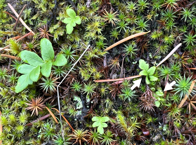
While you’re not likely to spot a gametophyte, juvenile Licorice Fern are common and easy to spot, if you look closely. Their emerging fronds are the size of thumbnail and they lack rhizomes at this stage in their growth. They are often pioneers, as well – tiny patches growing far away from established colonies.
Juvenile Licorice ferns just beginning to emerge from moss on a talus slope boulder along Tanner Creek. The two arrows point to new fronds emerging from gametophytes. The brown Douglas Fir needles provide scale in this tiny scene
Well-developed juvenile fronds in this new colony of Licorice Fern along Tanner Creek will remain small for the first few years until these plants develop mature rhizomes under the moss layer
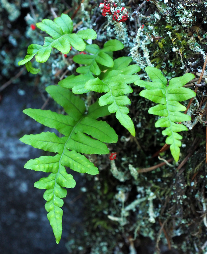
This young Licorice Fern has begun producing mature fronds – the wrinkles on the lower frond are from sori on its underside, where mature ferns produce their spores
Where do Licorice Fern get their nutrients when they typically do not grow in soil? The answer is that these plants are mycorrhizal, meaning they have a symbiotic relationship with fungus through their rhizomes and roots. In this relationship, the ferns use their green fronds to produce food through photosynthesis for the fungi, and in turn, the fungi provides minerals supplied from the substrate the plants are growing from. This is why it’s not unusual to find tiny Licorice Ferns growing from what sometimes seems to be solid rock.
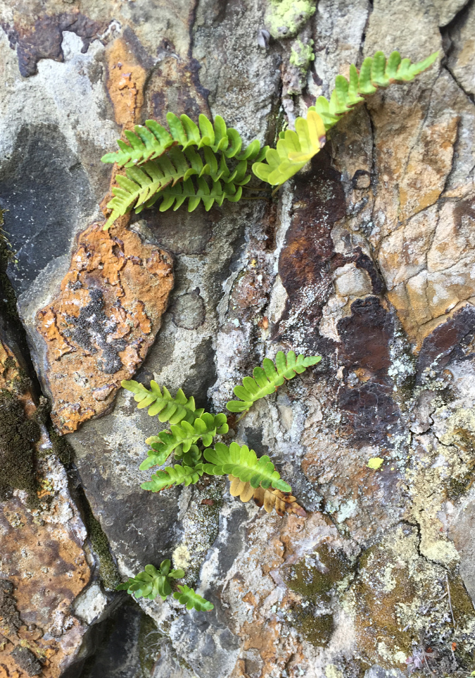
Tiny fronds no more than two inches long help these cliff-dwelling Licorice Fern survive where they have sprouted from small cracks in the rock
While not much is known about other organisms that depend on the Licorice Fern, they are considered to be an important niche habitat for other species simply because they grow where most other plants are unable to, thus providing shelter and food for insects and other wildlife living within fern colonies.
While researching this article, I was especially curious to know if the unique, lowland Pika population in the Columbia River Gorge relies on Licorice Fern for food or nesting material, since these intrepid animals have uniquely adapted to live in talus slopes in the Gorge, and feed on the moss that covers these rocky slopes. Hopefully, as this unlikely Pika population continues to be studied, we’ll learn if it has also developed a special reliance on Licorice Fern, as well.
Urban Licorice Ferns..?
A bit weather-battered after the January ice storm, but bouncing back quickly
Thirty-two years ago, I constructed a stone retaining wall in my backyard and — wanting that “Gorge” look that I’ve always admired – I laid a patch of moss with a few Licorice Fern rhizomes embedded in it across some landscape rocks, just above the wall. For a couple years the ferns struggled to establish, but over the years they’ve formed a tough, lush colony that has now spread to cover much of the retaining wall.
When I took the above photo in late January, they had been battered by an ice storm, but were quickly bouncing back to winter form, and providing welcome patch of green in our extended gray, rainy season!
The author in 1981 (at age 19!) beginning my infatuation with licorice-ferns — and stone walls — at Wahkeena Falls
Because I lightly water these plants in summer, they remain green year-round, even in the middle of our typically hot, dry Portland summers. These urban ferns have thus adopted a growth cycle of June through April, dropping most of their previous year’s foliage (with occasional human assist) as warm weather arrives in mid-May, then vigorously rolling out new fronds by early June – apparently “aware” that I’ll be providing light watering over the summer months.
The real surprise came a few years ago when the now, well-established colony on the rock wall spread to their preferred habitat on a nearby Hollywood Juniper, of all places. There was just enough moss on the shaggy bark of this 30-year-old tree to host the ferns, and they also benefit from being shaded by the juniper’s evergreen foliage during our hot summers in Portland.
Pioneering Licorice Fern in my backyard… on a Hollywood Juniper!
Last year, the new colony on the juniper expanded to include two tiny new colonies, just above it, in this unlikely location. Their life here is exceptionally dry during the summer season – no supplemental water and at least three months of drought each year. The original colony even survived our unprecedented “heat dome” temperature of 116 F in June 2021! These new colonies have thus adopted to the conventional growth cycle of Licorice Fern, and go dormant in late summer, then re-emerge in the fall.
New colonies are now forming near the original Hollywood Juniper colony
The above photo shows the spreading Licorice Fern colonies on my backyard juniper tree – including a gametophyte just emerging from the moss layer. While I think the parent colony for these ferns was the most likely from the nearby rock wall, it turns out that if you look up when you pass under large, moss-bearing street trees throughout Portland, you’re likely to see Licorice Fern taking root throughout the urban area.
This century-old Norway Maple (below) on my block has several large colonies among its sprawling limbs, as does the 60-year-old Norway Maple growing in front of my house. These colonies are thriving in the middle of the city, even as TriMet buses and other urban traffic on this busy street passes directly below them.
Licorice Fern colonies leafing out in early November on a Norway Maple street tree near my home in North Portland
As our climate continues to warm, we can only watch and learn how native plants will (hopefully) adapt. A few years ago, I wouldn’t have included any ferns on a list of resilient adapters to climate change, but the ability of Licorice Ferns to maintain an inverted growth cycle, scale their foliage to harsh local conditions and go dormant when droughts arrive should help them manage the changes ahead.
Bringing the Forest Home…
In our time of climate change, native species that have already adapted to seasonal droughts are great options to consider for home gardens. They’re low-maintenance, bug and disease resistant and require little or no summer irrigation once they are established. But perhaps most importantly, they bring a slice of our amazing forests right into our yards for people and wildlife to enjoy year-round. If you can’t be in the forest, bring the forest to you!
Oregon Grape collected along a forest road near Mount Hood three years ago, and now bursting from its gallon pot (including through the drain holes!), ready to be planted in the garden
I’m a longtime forest transplanter, and licorice fern are just one of the dozens of native plants I’ve collected for my home garden over the years. Like many, I’ve also gradually transitioned away from ornamentals that require heavy watering, yet still fare poorly in our increasingly hot summers.
Among my favorite transplants are the many Sword Ferns planted throughout my garden. They provide year-round green and show a similar toughness to Licorice Fern. While they don’t share the ability to flip their growing seasons, Sword Ferns are able to scale the size of their fronds to local conditions and are remarkably drought tolerant, even in direct sun. I’ve also planted Oregon Grape (pictured above), Deer Fern, Salal and many Vine Maple (below) throughout the garden.
Vine maple leafing out just a few weeks after I collected it in the Clackamas River area three years ago. After two years in a planter, it developed a healthy root ball, and was able to go into the ground last spring
But is it legal to collect transplants on federal land? It is, though you are limited to what the Forest Service defines as the “road prism”. Generally translated, is the area along forest roads that was disturbed by construction, either for drainage or slope cuts. That includes embankments and ditches. The schematic is provided by the Forest Service:
No permit is required for non-commercial collecting. Having done this many times, I recommend digging in February or early March, just before plants emerge from winter dormancy. And don’t try to get a root ball in the normal gardening sense – forest plants have long, meandering roots that wrap around rocks and under logs, so you’re likely to end up with a “bare root” plant, even if you try to dig soil along with your transplant.
Instead, my system is to not fight this “bare root” reality, and instead, embrace it. A shovel, pair of loppers and some hand pruners are the essential tools needed. Also, pack a few large, plastic trash bags with balls of dampened newspaper inside to keep the roots on your mostly bare-root transplants moist for the drive home. Then, plant them in the ground or in pots as soon as you’re able to.
I like to grow my starts in containers with potting mix for a couple years to give them a chance to recover and develop a true root ball, then plant them in the yard in fall. That seems to speed up their adaptation to urban life significantly. Soon enough, they’ll asking for overpriced coffee and gluten-free mulch… 😊
You can learn more about collecting plants on Mount Hood ‘s forest roadsides here:
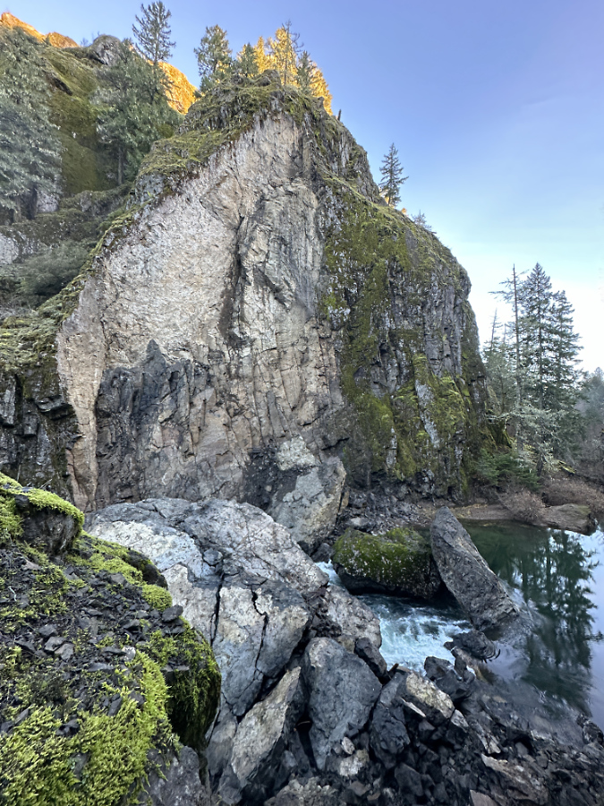
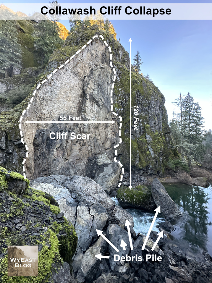
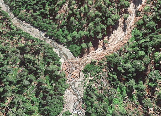
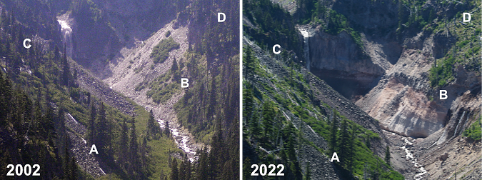
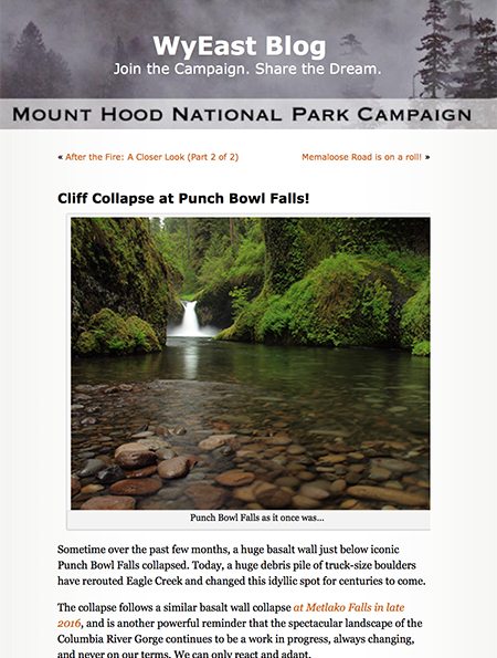
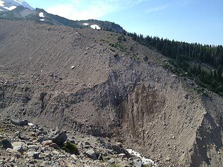
The recently collapsed cliff wall along the Collawash River
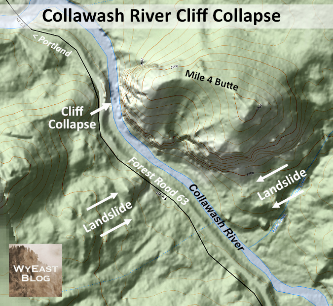
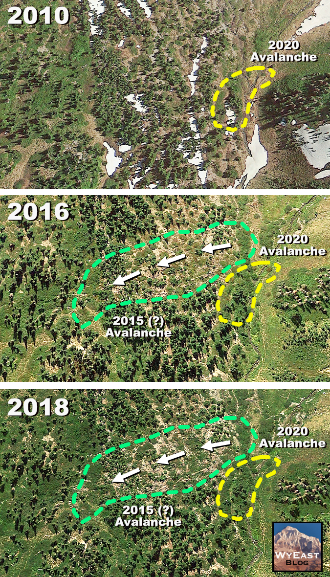
We’re experiencing a bit of a geologic moment in WyEast Country, of late. A series of major cliff collapses in recent years along well-known streams has given us a unique opportunity to see the raw forces of nature at work, shaping the landscape in real time, and also to witness nature rebounding after these violent events. Most of these recent collapses have been along streams in the Columbia River Gorge, but sometime over the past two years, the Collawash River joined the trend.
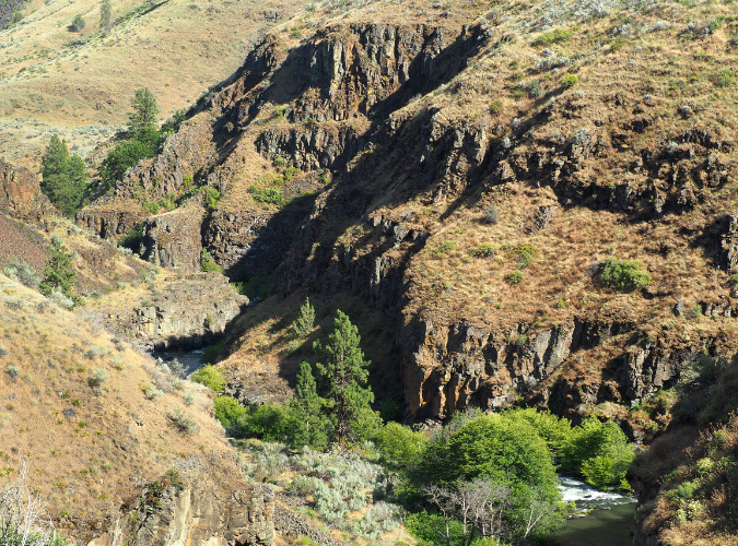
The Collawash River is special. Even in a region known for pristine, spectacular rivers, the Collawash stands apart. That’s in large part due to its unique geology. The Collawash River originates in the remote, rugged Bull of the Woods Wilderness and tumbles through a deep, forested canyon, made perpetually unstable by ancient landslides that are literally pulling the steep mountain slopes on both sides toward the stream.
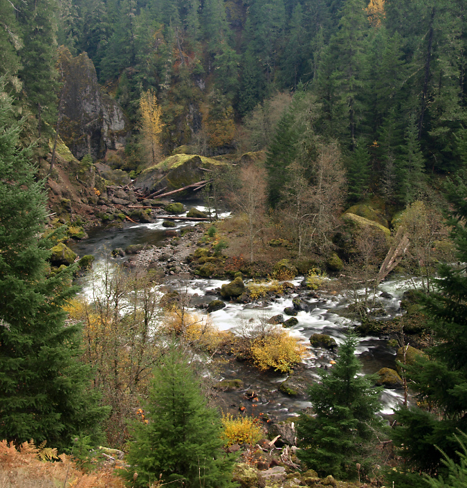
Massive landslides create a continually changing landscape along the rugged Collawash River
The result is very active landscape along the Collawash, with hundreds of massive boulders marking past landslide events scattered along its course. The ongoing landslides, combined with recent forest fires in the Bull of the Woods Wilderness have also created epic logjams where thousands of trees dropped into the river have accumulated behind these boulders in huge piles.
The erosive action of the Collawash River against the force of these landslides has the effect of a conveyor belt. During high water, the river periodically removes debris from the actively eroding toe of the slides, which in turn, triggers more sliding. This cycle has been playing out for millennia on the Collawash, gradually carrying material from the slides downstream into the Clackamas River, then beyond, leaving only large boulders behind. In time, even the largest of these boulders eventually give way to the elements, and are carried away by the river in pieces.
The dramatic, evolving scenery along the Collawash River is shaped by massive, collding landslides pushing into the river canyon from two sides
One of the many landslides feeding into the Collawash River
Along the way, these landslides also push the Collawash River against solid rock walls along its steep course, allowing the river to gradually cut away at these, as well. Like the erosive process described in this recent article, a solid rock wall that has been persistently undercut by the river eventually collapses, adding still more boulders and loose debris to the river.
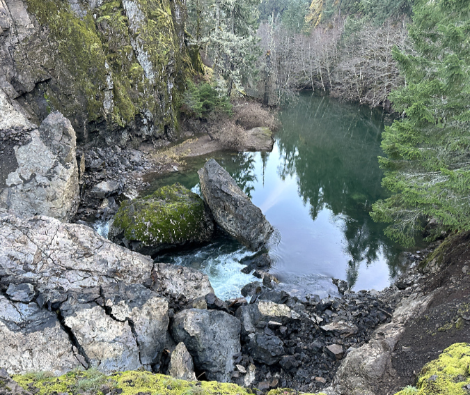
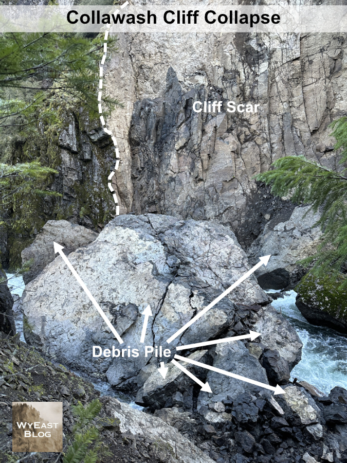
I unexpectedly came across just such an event this year along the Collawash River. The first clue was an eerie slackwater (shown below), with streamside Red Alder inundated under several feet of perfectly still, turquoise water. Just downstream was the answer to this strange anomaly. A massive rock slab had split from a tall cliff along the east bank of the river, crashing into the stream and creating a debris dam that formed a temporary lake on the Collawash.
The eerie, still pool in the Collawash impounded by the recent debris pile
The new debris pile in the foreground and the impounded, temporary lake on the Collawash
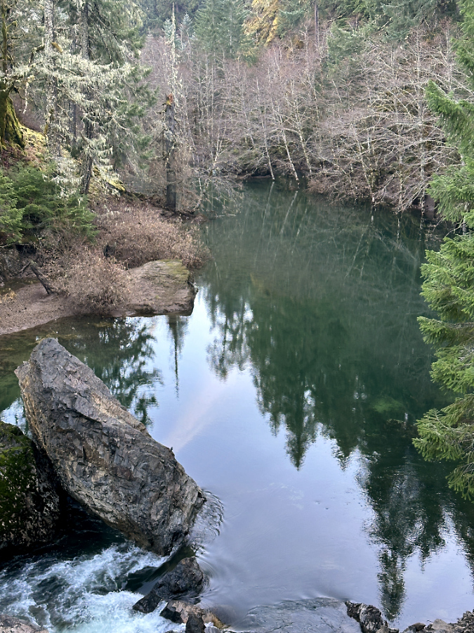
The river has since breached the debris pile and is now beginning to carry away fine debris. Note the inundated Red Alder trees in the background
Based on available air photos, the collapse occurred sometime between July 2021 and August 2023 — the 2021 image shows the free-flowing river and the 2023 version clearly shows debris the cliff collapse. While these events can occur at any time of year, those we have seen in recent years have mostly happened during the wet winter months, when the forces of erosion are at their peak.
Based at the state of the debris pile, I would guess that this cliff came down sometime in the winter 2021-22, roughly two years ago. Why this guess? Because with events like this, the debris pile is usually loose enough for the stream to initially flow under it – like a sieve – until the pile settles and when fine material carried in the stream begins to plug small gaps in the settling pile. The other clue is the lack of fine material on top of the pile – the Collawash has clearly had some time to scour the pile of small debris during at least one season of high water.
(Update: per Ian’s comment, below, the Forest Service estimates the collapse to have occurred in February 2023 — a full year later than my guess! They also reported that at that time, the entire river was flowing through the debris and had not yet overtopped it, where today a significant amount of the flow is overtopping the debris. The Collowash is making quick work of this blockage!)
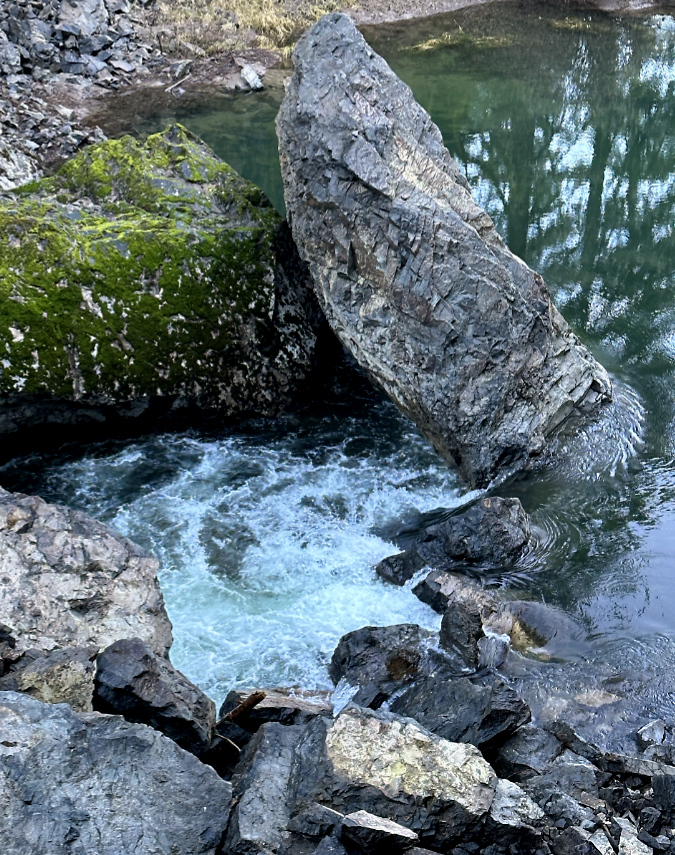
Though a portion of the river’s flow is now cresting the debris pile, much of the flow is still flowing through the loose debris
As with other cliff collapses, several very large pieces of intact cliff survived the fall, but these are already beginning to buckle from their own weight. As the stream continues to churn away at the smaller debris in the pile, the huge boulders sitting on top face enormous stress when the underlying debris beneath them shifts. An especially impressive, house-sized slab that is the largest among the boulders to survive the collapse (below) is already showing large stress cracks. It, too, will eventually break apart as the debris pile continues to shift and erode.
The largest of the intact cliff sections is this behemoth, roughly the size of a small house. Stress cracks are already forming as gravity and the shifting, eroding debris flow beneath the boulder continues to move
Downstream from the debris pile the Collawash River roars through a new Class 5 rapid created by the debris (below). The erosive energy of this steep, newly-formed rapid is immense. Over time it will erode the debris pile from below, continually pulling material from the collapse downstream and allowing the river to cut more deeply into the remaining pile.
New Class V rapids formed below the debris pile where the Collawash is now much steeper than before
Looking downstream from the collapse section, giant boulders in the distance (now moss-covered) from previous collapses reveal the most recent event as just another in a perpetual process of river erosion here
The erosive energy now concentrated in the new rapids just below the debris pile is hydro-physics in action. The panoramic view of the collapse (below) tells the story: the temporary lake on the right hides a series of pools and rapids that existed upstream before the slide, and this energy has now been displaced to the new rapids in the downstream section, just below the slide.
Panoramic view of the cliff collapse showing the impounded lake (right) upstream and the new rapids (left) downstream created by the debris pile at center
This amount concentrated energy of focused on the lower end of the new, unconsolidated debris pile means the river will quickly win the battle of rock versus water that is on full display here. Eventually, this will become what kayakers call a “boulder garden”, eventually draining the temporary lake and leaving only a few of the largest boulders in place to mark the site of cliff collapse. This is only the latest of many such events at this narrow bend in the Collawash River, and it won’t be the last.
The following schematics show the newly exposed cliff scar and the debris left by the cliff collapse in more detail:
The collapse created a 120-foot vertical scar in the cliff
The debris pile from the collapse is dominated by this massive 25-foot wide boulder
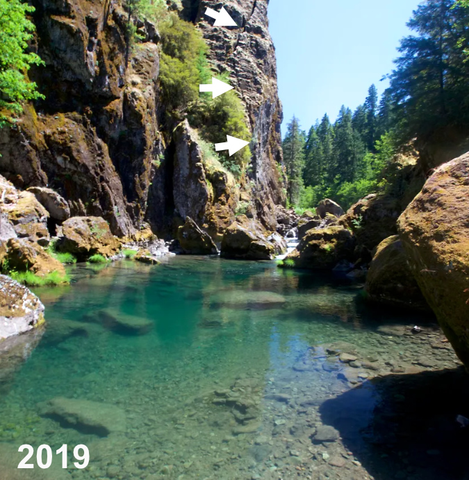
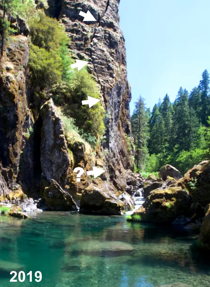
In researching this article, I stumbled across an image captured by outdoor writer Zach Urness in the summer of 2019 at the popular swimming hole just below these cliffs. To my amazement, you can plainly see that a prominent crack had formed in the cliff face, and matches the outline of the eventual collapse! I’ve marked it with a series of arrows in the photo below.
View of the Collawash River cliff before the collapse with arrows marking the obvious crack that was forming (photo: Zach Urness)
Closer view of the Collawash River cliff before the collapse with arrows marking the crack that would eventually lead to the collapse (photo: Zach Urness)
Zach’s photo also shows how this spot in the stream was already littered with large boulders from prior collapses before the collapse. There’s no way of knowing when these earlier events occurred, but we do know from witnessing the latest collapses here and elsewhere in WyEast Country that they are more common – and constant – than we once thought.
The lack of photos or reporting on the collapse has a silver lining: Zach’s photo was taken from just above the Little Fan Creek picnic area, located at the confluence of the main Collawash and Hot Springs Fork. This area is especially popular with families in the summer months, with crowds of people floating and swimming the many pools in the river, and where a summer event might have had deadly consequences.
How to see it for yourself…
The graceful Collawash River Bridge was constructed in 1957 as part of logging heyday in the upper Clackamas River watershed
The recent cliff collapse on the Collawash River is easy to visit if you’re looking for a weekend drive. The winter off-season is the best time, too, as the Clackamas River corridor is popular and often busy during the spring and summer months. To reach the site, head up the Clackamas River Highway (OR 224) for 26 miles east of the town of Estacada to the Ripplebrook ranger station and campground, Here OR 224 becomes Forest Road 46. Continue for another 3.5 miles on FR 46 to an obvious (but usually unsigned) junction with the paved Collawash River Road (Forest Road 63).
Turn right onto FR 63, and be sure to take your time along this stretch. Here, the road hugs the Collawash River through an exceptionally scenic and geologically interesting areas. You will immediately cross a beautiful arched bridge over the Collawash as you enter the river’s narrow lower canyon on FR 63. Views of dramatic cliffs, river rapids and impressive old growth trees are at every turn, with frequent pullouts for stopping.
Autumn scene along the Collawash River Road
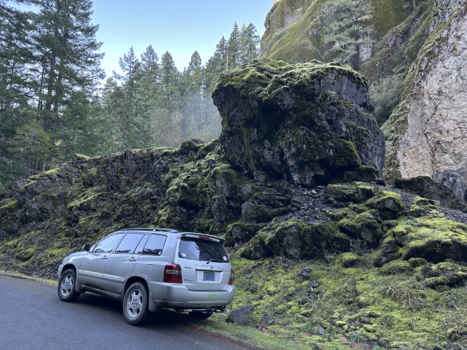
At about the 4-mile mark you will reach another junction, where paved Forest Road 70 heads right to well-known Bagby Hot Springs, located on the Hot Springs Fork of the Collawash River. Stay straight on FR 63 from this junction and immediately cross the Hot Springs Fork on second bridge. The recent cliff collapse is just upstream from here, so watch for an obvious boulder perched on a pile of moss-covered rock on the east side of the road (shown below). This is where the collapse occurred.
There’s room for shoulder parking next to the perched rock, and the best view is from the upstream side of the big boulder, on top of the rock pile. Use care scrambling up the rock pile – there’s a steep drop on the opposite side!
While it looks poised to roll onto my car, this boulder is from an earlier cliff collapse that occurred well before the Collawash River Road was built in the 1950s. The best viewpoint of the latest collapse is from the top of this rock pile, next to the big boulder
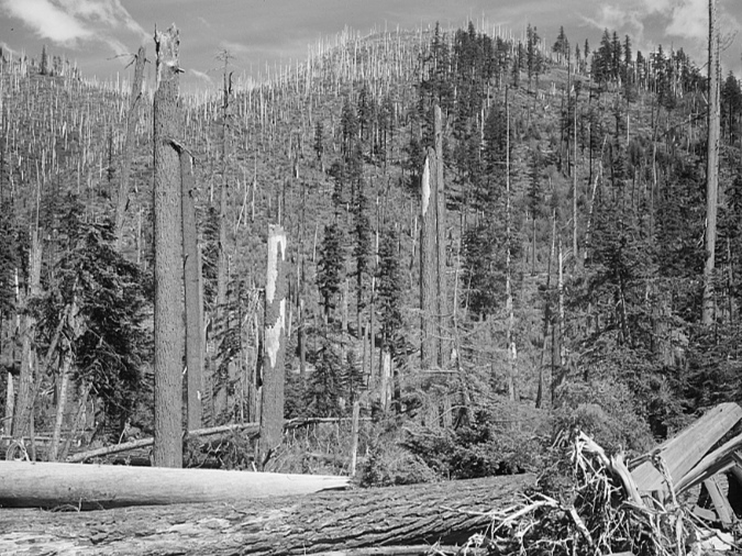
Though the Collawash River was mostly spared by the Riverside Fire that swept across 138,000 acres in the Clackamas River watershed in 2020, the Clackamas River Highway route to the Collawash River travels through much of the burn. While this might sound a bit bleak for a scenic drive, it’s a great opportunity to fully appreciate the scope of the burn and watch the beginnings of the post-fire forest recovery here.
The Riverside Fire was the third and largest of three human-caused fires to sweep through the Clackamas River canyon over the past two decades. While fires are a natural and necessary element to forest health in the Pacific Northwest, it’s also true that human-caused fires are burning the Clackamas River basin (and many other forests in the Pacific Northwest) at an unsustainable.
The human-caused Riverside Fire roared across the Clackamas River area in September 2020 burning 138,000 homes and dozens of structures in its path
Human-caused fires are also killing old-growth riparian trees that have survived centuries of wildfires. Why? In part because of the intensity of these recent burns as a result of decades of fire suppression, but also because riparian areas were often be spared in the past by natural, lightning-sparked fires that typically began on exposed, drought-stressed ridgetop forests – not in moist rainforest canyons, where all three of the human-caused fires on the Clackamas started.
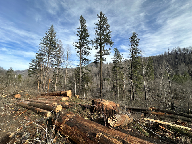
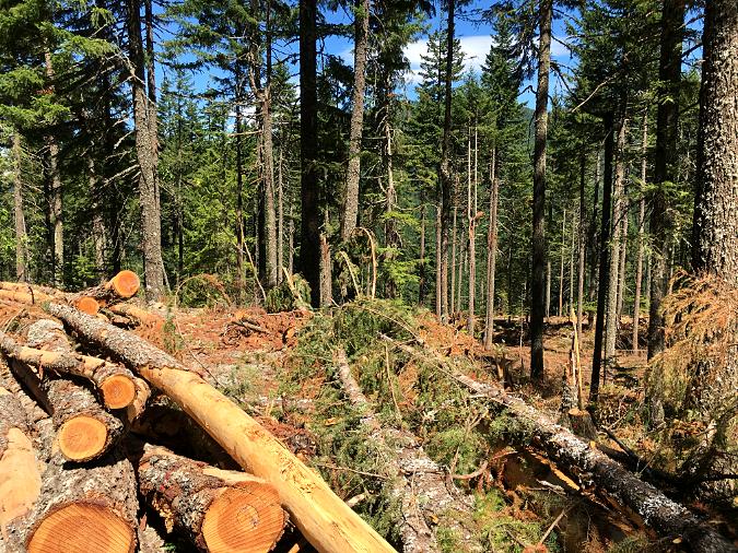
The Forest Service is still gradually reopening the many campgrounds and picnic areas along the Clackamas River that were affected by the burn, so you are likely to encounter logging operations where trees deemed “hazardous” are being removed by contract crews. These projects are well-signed and easy to avoid if you’re following the main route.
The Forest Service is still logging fire-killed or weakened trees like these along major forest roads in the Clackamas area as “hazard trees”
For a longer tour, you can continue further upstream along the Clackamas River Highway from the Coillawash River Road junction. The highway hugs the Clackamas River for another eight scenic miles, with pullouts along the way to appreciate the views. This section of the highway passes Austin Hot Springs, an interesting area, but also a private inholding within the national forest, and not open to the public.
Above the Collawash River confluence, the main Clackamas River is unburned and a reminder of what the lower canyon looked like before the 2020 Riverside Fire
As you explore the area, you may begin see each vertical cliff and outcrop with new eyes as – perhaps – the next real-time geologic event! Chances are slim that any of us will witness such an event, but seeing the aftermath of the Collawash River collapse gives a new appreciation for the constant natural processes that continue to shape the scenery around us.
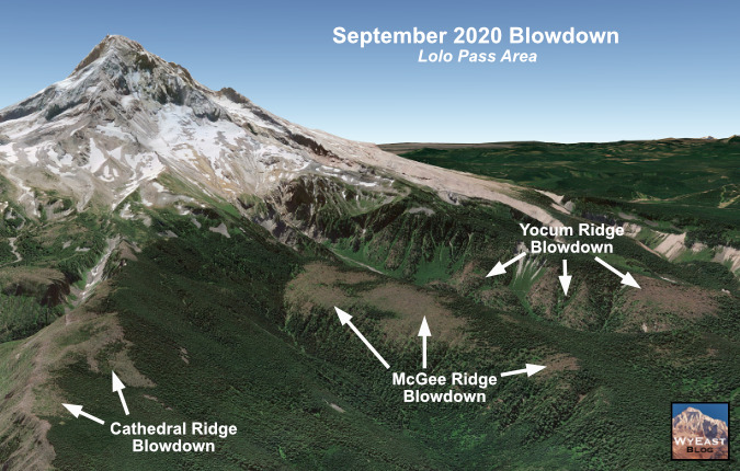
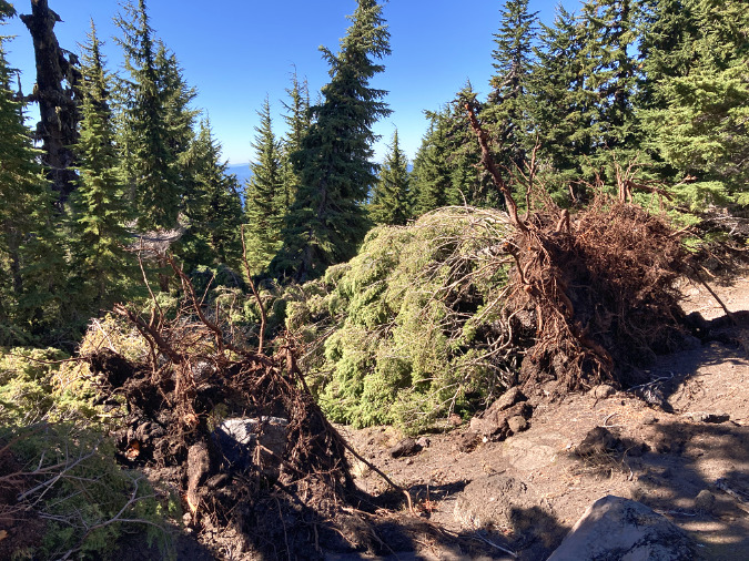
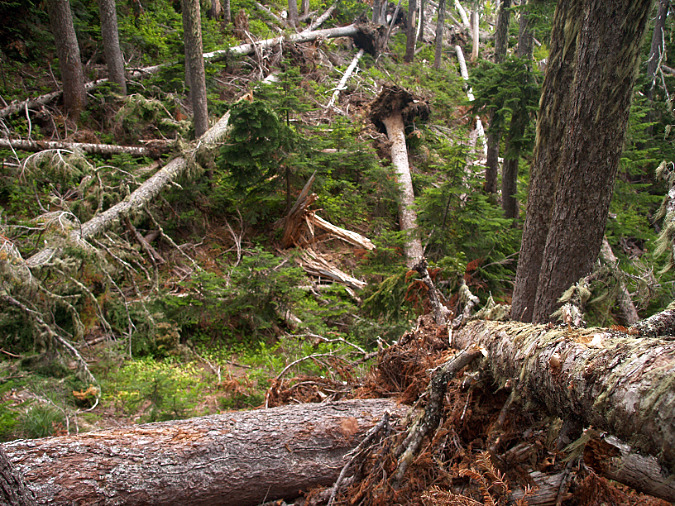
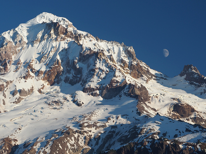
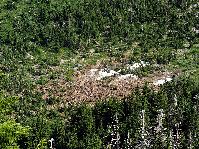
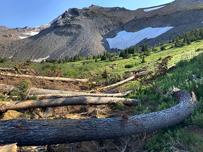
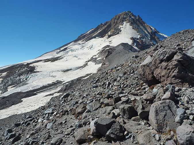
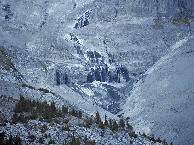
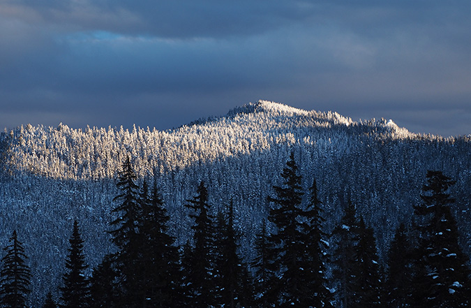
Blowdown from the 2020 wind storm on Mount Hood’s McGee Ridge
The spectacle and impact of the massive forest fires that exploded in the northern Oregon Cascades in September 2020 overshadowed widespread blowdown events that might otherwise have made headlines at the time. The two were linked, with a strong east-west atmospheric pressure gradient producing gale-force winds along the Cascade Crest during the driest month of our annual summer drought.
Like the recent forest fires in the Gorge, on Mount Hood and the Riverside Fire that swept much of the Clackamas River watershed, many of the recent blowdowns on Mount Hood are in plain sight and have since added to the public anxiety over the future of Mount Hood’s forests.
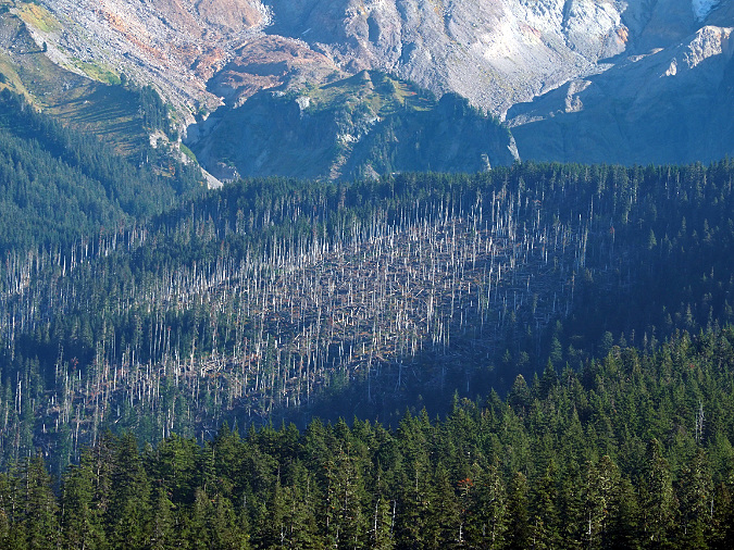
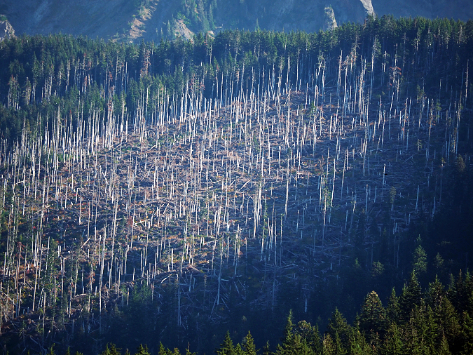
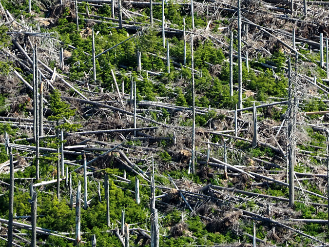
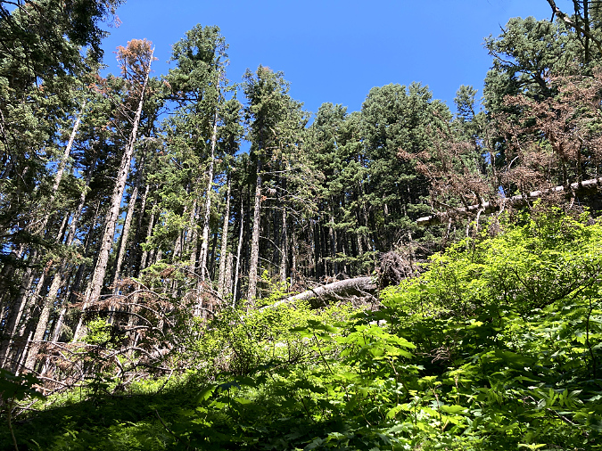
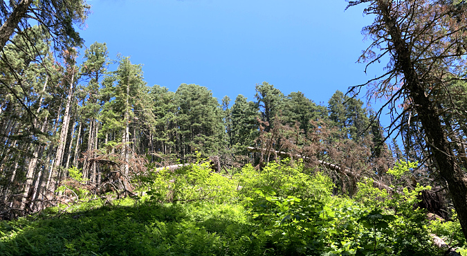
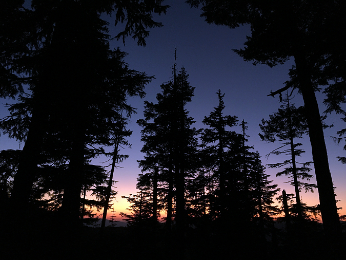
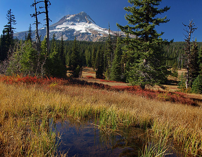
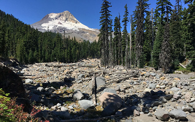
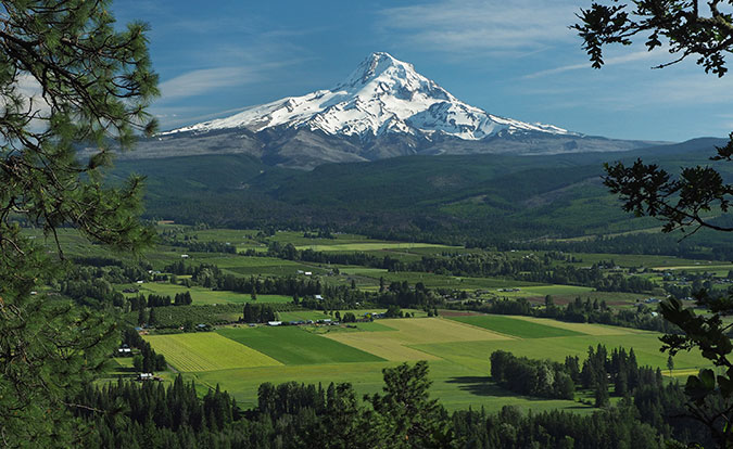
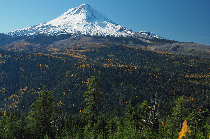
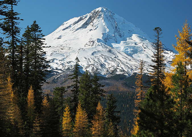
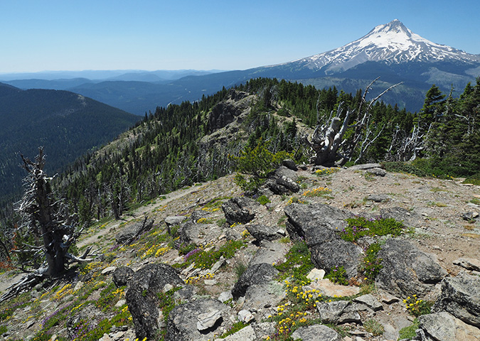
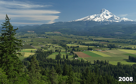
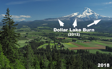
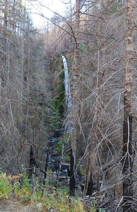
On Mount Hood’s slopes there were large areas of blowdown from this event along Cathedral Ridge, McGee Ridge and Yocum Ridge, with smaller blowdown patches scattered along other ridges around the mountain and on smaller peaks along the Cascade Crest. One of the more prominent blowdown areas on the shoulder of McGee Ridge is prominently visible from Lolo Pass (shown in the opening photo and below).
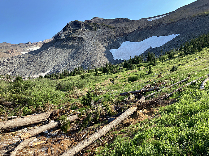
Closer view of blowdown on McGee Ridge
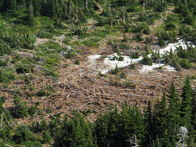
Detailed view of blowdown on McGee Ridge
The visual impact of whole forest stands being toppled like matchsticks is jarring enough, but in the case of the Yocum Ridge blowdown, an entire section of the Timberline Trail was also impacted.
While these events seem new and troubling, blowdowns — like wildfires – are endemic to our forest ecosystem. As such, blowdowns have emerged in recent years as a topic of increased interest to forest scientists. This article draws from the changing understanding of extreme wind events as a normal, mostly beneficial contributor to forest health in WyEast Country, complementing natural forest fires in surprising ways.
Recent Events on Mount Hood
The recent blowdown events on Mount Hood are hard to miss for those who spend time on the many trails that encircle the mountain. Most occurred during the September 2020 event, but there were earlier events on a smaller scale that point to blowdowns as a regular, ongoing force shaping our forests.
The 2020 event brought down whole forests on Mount Hood’s northwest slopes (below), leaving a tangle of fallen trees in their wake. Most trees were snapped off or tipped, with with their root ball on end and their tops pointing in the direction of the prevailing wind force. While a few trees within the blowdown areas managed to remain standing, they were stripped bare of limbs and foliage, and few eventually survived the destructive impact of the event.
The September 2020 windstorm created large areas of blowdown on the forested ridges that radiate from Mount Hood
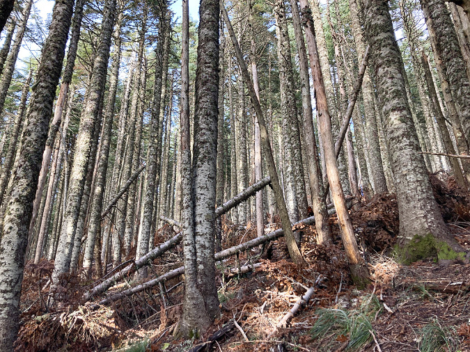
Less obvious from a distance are the thousands of trees that fell within the still-standing forests that border the blowdown areas. Outside the major blowdown areas, there were many scenes like those shown below on ridges and steep slopes around the mountain.
Though this forest on Bald Mountain was largely spared, many small trees within the canopy were still toppled in the September 2020 wind storm
The September 2020 wind event had the effect of thinning this young forest near Lolo Pass by toppling small, struggling trees within the canopy
Meanwhile, the 2020 storm also toppled hundreds of timberline trees on the south side of the mountain. Most of these were thick-trunked, ancient Mountain Hemlock, and they were simply tipped, roots and all, by the high winds. The south side blowdown was less extensive, however, with scattered trees tipped in a seemingly random fashion (below).
Ancient Mountain Hemlocks near Timberline Lodge were toppled during the 2020 wind storm
Upturned roots of toppled Mountain Hemlock above Zigzg Canyon on Mount Hood
Localized blowdown from the 2020 wind storm in a Mount Hemlock forest above Zigzag Canyon
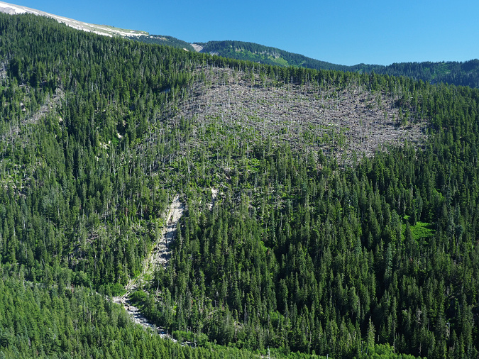
The blowdown on Yocum Ridge was the most widespread and complete, leveling several hundred acres of Noble fir and other mountain conifers (below). The effects here were immediate for hikers, as scores of ancient Noble Fir fell across the Timberline Trail between Ramona Falls and the Muddy Fork crossing. These piles of old-growth logs took volunteer crews hundreds of hours to chip away with handsaws, as this area is within the Mount Hood Wilderness, where motorized equipment is prohibited.
This large blowdown area from the 2020 wind storm is on the north slope of Yocum Ridge
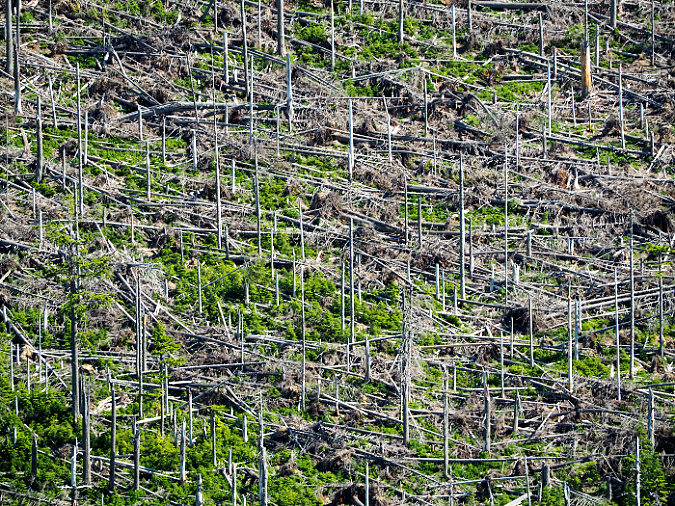
Closer view of the Yocum Ridge blowdown area showing alignment of downed trees that reveals the wind direction during the storm
Detailed view of the Yocum Ridge blowdown area showing the dense understory of young Noble Fir that have already begun replacing this downed forest
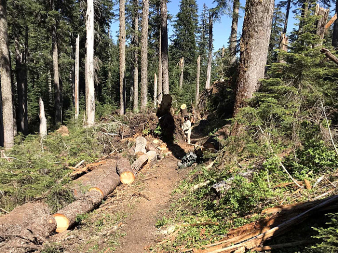
The blowdown on Yocum Ridge in 2020 covered the Timberline Trail with large, old-growth logs for nearly two miles (photo: Trailkeepers of Oregon)
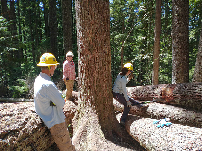
Trail volunteers beginning the work of clearing blowdown below Yocum Ridge (photo: Trailkeepers of Oregon)
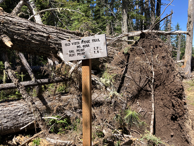
At the north end of the Mount Hood Wilderness, the 2020 wind event toppled hundreds of trees along the Old Vista Ridge trail, especially in the low, wind-exposed saddle that divides the West Fork and Clear Fork drainages (below). Like the south and west side blowdown areas, some trees were simply snapped off, but most were tipped, pulling their roots from the thin mountain soils that are typical along Mount Hood’s ridges and subalpine slopes.
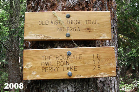
This pair of 150-year-old trees were tipped during the 2020 wind storm, and somehow left the Old Vista Ridge trailhead sign intact
Blowdown from the 2020 wind storm along Mount Hood’s Old Vista Ridge Trail
Blowdown from the 2020 wind storm along the Old Vista Ridge Trail
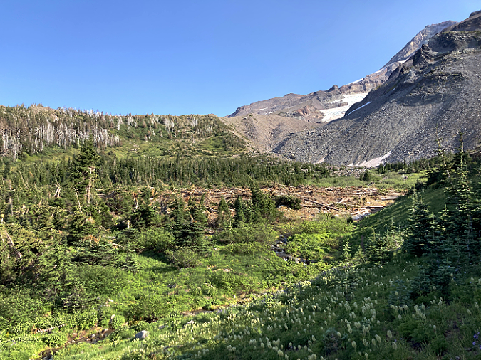
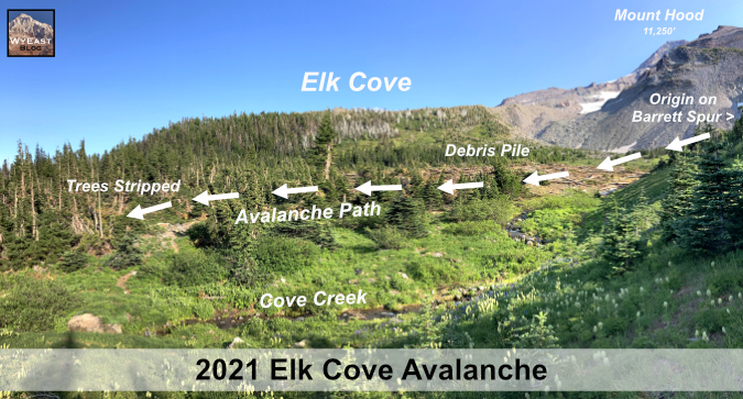
Volunteers from Trailkeepers of Oregon (TKO) eventually cleared the Old Vista Ridge trail in 2021, though some sections had to be re-routed where the entire tread was pulled up or covered by upturned root balls. Among the other poplar trails on Mount Hood affected by the 2020 blowdown were Elk Cove, Vista Ridge, Cathedral Ridge, Bald Mountain, Yocum Ridge, Hidden Lake and Paradise Park.
Natural Forest Blowdown vs. Logging Blowdown
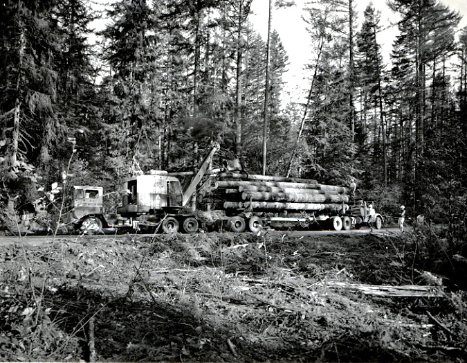
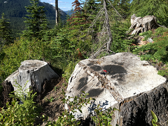
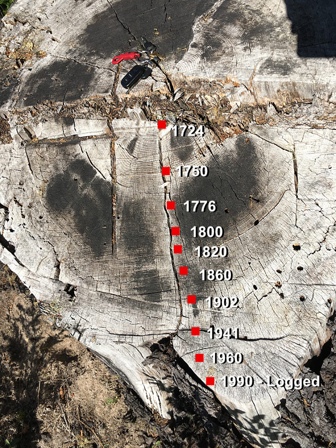
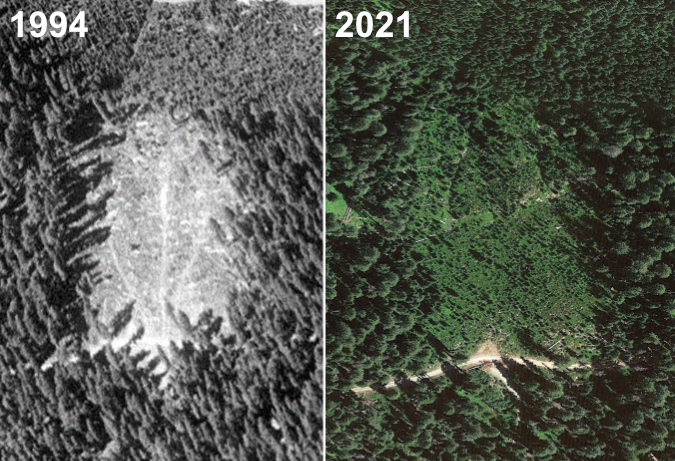
For many years during the logging heyday that extended from the 1950s into the 1990s on our public lands, blowdown was a growing concern that highlighted the many ecological problems with clear-cutting our forests. This was especially true in high-elevation forests, where you can still find piles of fallen trees in the intact forests that border clearcut areas, such as the scenes below on the shoulder of Lookout Mountain, just east of Mount Hood. This clearcut at Horkelia Meadow dates to the 1990s, yet the resulting blowdown impact on the adjacent forest continues today.
Blowdown near Horkelia Meadow resulting from a 1990s clearcut that exposed the remaining forest to new wind loads
Blowdown near Horkelia Meadow bordering a 1990s clearcut. The fallen trees point away from the clearcut
Similar impacts of clearcutting on blowdown were on display adjacent to the 1980s Boundary Clearcut, on Mount Hood’s north side, and along the north wall of the Clear Branch valley, at above Laurance Lake (below). These blowdown impacts from logging are more the rule than the exception where logging is allowed at high elevations and along subalpine ridges.
Clearcut-driven blowdown along the Boundary cut, on Mount Hood’s Vista Ridge
Wind-damaged forests above Laurance Lake (upper left) resulting from exposure created by the adjacent, large 1950s clearcut (forested area on the right)
Blowdown damage along clearcuts differs from that produced in natural forests by extreme wind events. In these logged areas, shallow-rooted conifers along the intact forest margins are suddenly left exposed to wind loads that the once-standing, clearcut forest had protected them from, and thus are easily toppled by normal winter storms.
The vulnerability of trees growing in these clearcut margins can continue for decades after logging occurs, as it takes years for the newly exposed trees to adapt their roots and canopy to the new wind pressures they face. These trees are especially vulnerable to more substantial wind events that they might have otherwise survived. Such was the case in the 2010 blowdown shown on Vista Ridge (above), where centuries-old trees adjacent to the Boundary clearcut were brought down by a typical strong winter storm some 30 years after the adjacent forest had been logged off.
Age + Terrain + Season = Destiny
New research on large blowdown events in established forests draws some fairly intuitive conclusions about the relationship of terrain and season to these events. Not surprisingly, places that are already predisposed to extreme wind by their geography are most vulnerable to blowdown in major wind events. Likewise, saturated soils during the wet winter months can make forest more vulnerable to high wind events.
Despite their towering size, the big conifer species in our forests are surprisingly shallow-rooted compared to many deciduous trees that have a deep taproot. This makes our conifers especially susceptible to tipping under high wind stress. As a result, recent studies of blowdown events in the Cascades show that uprooting accounts for the vast majority (about 85%) of trees toppled in our evergreen forests, with only a small number of trees (about 15%) snapped off.
Their shallow root system and vulnerability to tipping is also why conifer forests are susceptible to widespread blowdown events, with falling trees often knocking down or jarring other trees in their path, creating a domino effect that can quickly level entire stands.
Blowdown near Government Camp photographed in the early 1900s – along with a ghost forest produced by fire on the distant hilltop. Fire and wind are not new to our forests, and we’re learning they are an essential part of forest health
Elevation and terrain also make a big difference, especially in winter. Evergreen forests growing above the snow line often have a combination of saturated soils with heavy snow accumulation in their canopy during the early winter months, adding to their vulnerability in a high wind event.
Studies of recent blowdown events in the Cascades also show that even-aged stands are more likely to suffer widespread impacts than forests with mix-aged stands. This is particularly concerning, given that the continued practice of clearcutting and planting logged areas with single-age stands of Douglas fir has produced millions of acres of same-aged plantation forests across the Pacific Northwest. Surprisngly, blowdown research also shows that in mixed-age stands, larger trees are disproportionately impacted by high wind events, despite less widespread impact on the overall stand. This is somewhat intuitive, since these are the trees with the greatest mass and height, and thus take the brunt of the wind load. But it also points to a virtuous cycle of forest succession (discussed below).
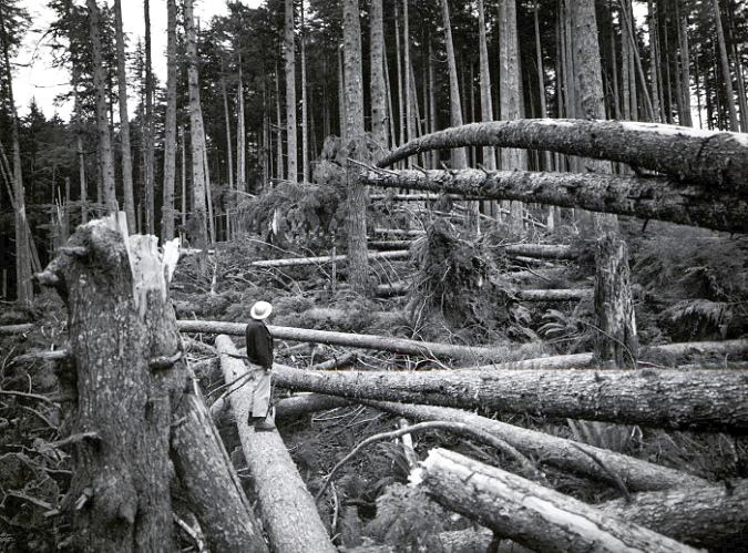
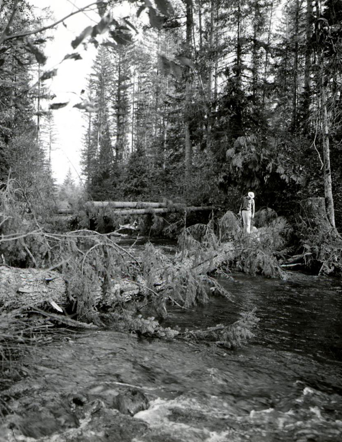
Blowdown in the Clackamas River drainage from the 1962 Columbus Day Storm
Because major wind events tend to affect larger trees, windstorms often have an inverse effect on subsequent forest recovery from wildfire. Low-intensity fires typically burn the understory while leaving large, fire-resistant species (like Ponderosa Pine, Western Larch and Douglas Fir) intact. In contrast, wind events often bring down the largest, oldest trees, leaving the understory intact.
This effect of wind on the largest trees is an important part of forest health and succession, though one that has been recently appreciated and studied by scientists. If you’ve explored the forests around Mount Hood, you’ve probably noticed that uprooted conifers create large mounds of soil around their exposed root mass, and a shallow pit where the tree once stood. This freshly exposed soil combined with newly created access to sunlight to makes these disturbed spots a thriving seedbed for new understory plants and conifer seedlings. Over time, the fallen tree, itself, will also provide shelter and habit for wildlife, and as it decays, becoming a nursery for young trees.
While less common, snapped trees from extreme wind events also play an important role in forest health by providing habitat for cavity-nesting birds and mammals, while their decaying standing trunk becomes a food source for wildlife feeding on the insects and fungi that immediately begin digesting the wood.
Foresters rushed loggers into affected areas after the 1962 Columbus Day Storm to remove fallen trees for milling before they were “wasted” to decay in the forest
Blowdown events can affect areas ranging from a few dozen to a few hundred acres, typically in a patchy, highly variable pattern. Compared to blowdown along the uniform boundaries of a clearcut, scientists have also found that the complex shapes of large, natural blowdown areas helps speed forest regeneration from adjacent standing trees by leaving much of the affected area in close proximity to surviving trees that will reseed the impacted forest.
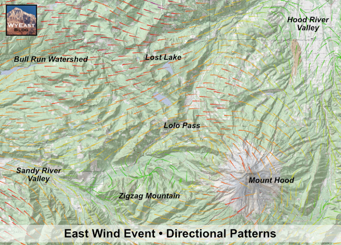
While snow and saturated soils can make our forests more vulnerable to high winds, elevation and exposure remain the drivers of major blowdown events. The September 2020 windstorm showed that even during our driest time of year, an unusually potent windstorm can have widespread impacts. The combination of wind speed, elevation and exposure correlated closely with the ridge tops and adjacent slopes where the heaviest blowdown occurred on Mount Hood. This event was especially unusual for late summer, as there was a strong, easterly wind blowing along the entire crest of the Cascades, as opposed to the normally westerly flow that dominates our region.
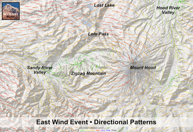
The two National Weather Service-based maps (below) for the September 2020 wind event are otherwise identical, except the second map excludes vegetation for ease of reading. The arrows point in the predominant direction of the wind during the event, and combine to show the rivers of fast-moving air that were flowing over the Cascades and toward the Willamette Valley. The arrow colors indicate wind speeds: green shows protected valleys where wind speeds were less, while orange shows steady winds of over 30 mph and red shows where steady winds exceeded 40 mph – though there were much higher wind gusts during the event, as well.
Wind map from the September 2020 wind storm showing the directional flow from east (right) to west (left)
This is the same map shown without vegetation to reveal the complex flow patterns as the wall of wind pressed across the Cascades from the east, roaring across high ridges around Mount Hood
The patterns revealed by the directional arrows show the air mass speeding up as pours over the Cascade Crest, from east to west, then rushes down the western valleys of the Cascades toward the Willamette Valley. Mount Hood forms a noticeable “wind shadow”, especially along the Sandy River valley, due west of the mountain, where sustained wind speeds dropped to 10 mph. The wind shadow of the mountain wasn’t enough to protect the forests along the upper slopes high ridges that radiate from the mountain, however, and this is where the main blowdown occurred.
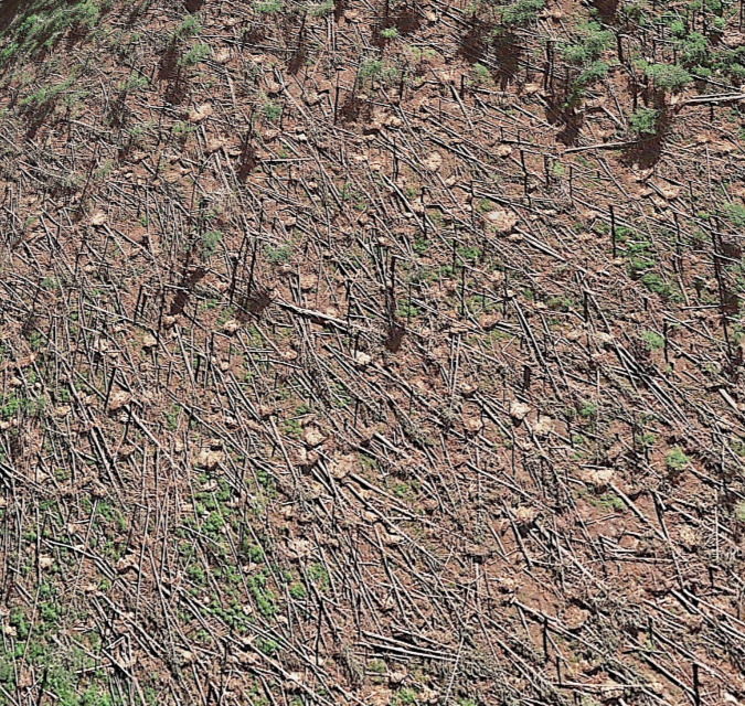
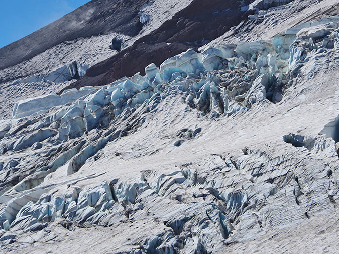
While these wind maps were created with a combination of monitored weather data and window flow models, the downed trees on Mount Hood north, west and south sides follow the pattern exactly. This satellite image (below) shows the blowdown areas along Yocum Ridge, where sustained winds of 40+ mph were sweeping down the west slopes of Mount Hood.
Google Earth images of Yocum Ridge from 2021 showing the extent of the blowdown
The closeup satellite image of the same area on Yocum Ridge (below) shows how consistent the sustained winds in this event were with the directional patterns that were modelled, with their toppled trunks pointing in the same direction as the arrows on the wind maps. The light-colored dots are tipped root balls from toppled trees.
This Google Earth view of the Yocum Ridge blowdown area shows the hundreds of upturned root balls dotting the September 2020 blowdown area
As distressing as it is to walk through a badly damaged forest after one of these events, we also know that extreme wind is a constant over time in our forests. Like fire, we have a history of treating these events as an anomaly, something out of the ordinary. Yet, research shows just the opposite – that extreme wind events and the blowdown that results are as much a part of our forest ecology as rain, snow and fire. Like the other natural forces, our forests have evolved with extreme wind as a relative constant, and the forest ecosystem is renewed by these events just as it renews and rebounds after a fire.
Rethinking Blowdown
Scientists categorize recurring wind events as “chronic” and “acute”. Chronic wind events include the typical storms that are part of every Pacific Northwest winter. These are the routine winds that annually shape the canopy of forests on lower slopes and sculpt our alpine “krummholz” trees at timberline. Except where forests are disturbed by clearcuts (as described above), these events typically don’t create significant blowdown, though they do invigorate tree growth by trimming limbs and selectively downing disease or drought-weakened trees.
“Acute” events are what our Cascade forests experienced in September 2020. These events may seem exceptional and catastrophic because of their impact, but they are as predictable as chronic wind – just on a longer scale. These are the events that produce significant blowdown, which, in turn, creates a cascade of beneficial effects for our forests.
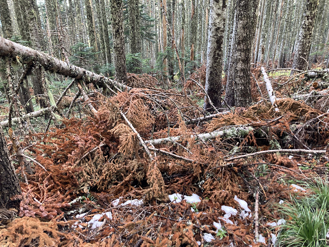
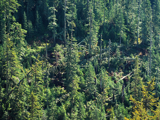
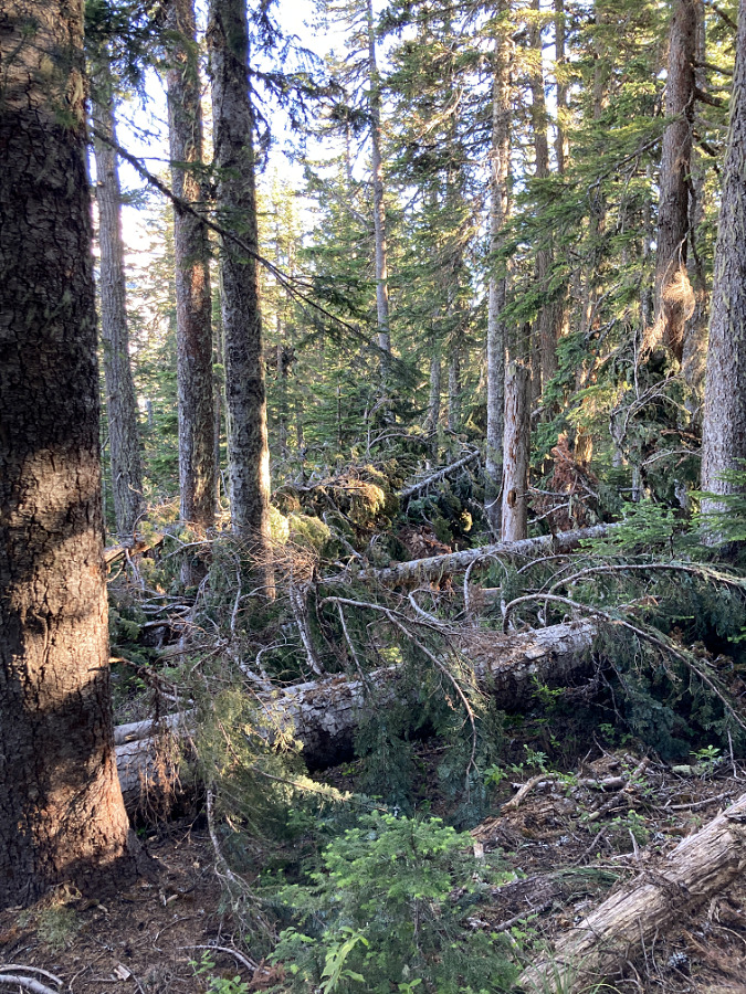
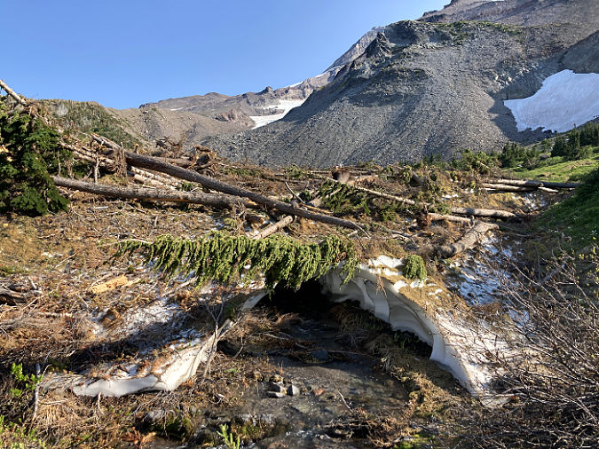
The rainforests on Mount Hood’s western slopes quickly hide blowdown with a thick layer of moss and ferns. There are at least a dozen fallen trees of varying size in these old-growth scene along Three Lynx Creek
While there are the immediate forest benefits of new forest openings, upturned soil and wildlife habitat created where downed trees fall, one of the most important benefits comes from the blowdown that makes its way to our streams. This can be from trees simply falling into streams (as shown above), or sliding down steep mountain slopes to reach nearby streams.
This satellite image of the Muddy Fork of the Sandy River (below) shows the immediate introduction of fallen logs just downstream from the September 2020 blowdown on Yocum Ridge. While only a fraction of the trees toppled by the storm made it into the Muddy Fork, they have already had an immediate and visible benefit by adding what biologist call “woody debris” to the stream. These logs will improve stream health by slowing the flow of runoff, creating pools for fish habitat and providing new wildlife habitat in and along the stream.
Google Earth image showing large log jams along the upper Sandy River just one year after the 2020 wind storm
Since the 1990s, scientists have become increasingly aware of the importance of woody debris to stream health. This awareness resulted from the lack of wood in our streams, following a century of fire suppression and heavy logging that deprived our streams of forest debris, leading to stream channel erosion and few pools for fish to spawn and their hatch to grow.
Logjam along Multnomah Creek resulting from upstream blowdown in the Eagle Creek Fire burn zone
This giant log was blown down across a stream in the Clackamas River drainage during the 1962 Columbus Day Storm. Old-growth logs can last for decades in a stream. This log likely survives today, more than sixty years later
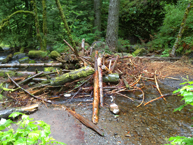
Today fish biologists have begun restoring streams affected by logging and fire suppression by artificially placing logs and root balls in streams to restore the complex mix of wood and gravel that was once typical in all of our Cascade streams and rivers. The man-made pile of logs in the example shown below is on Still Creek, which flows from Mount Hood’s south side. The hope is that these log piles will not only slow the stream and create spawning habitat for endangered salmon and steelhead, but also provide organic nutrients for aquatic insects and flora that fish fry need to survive.
Man-made log jam along Still Creek placed here to enhance fish habitat
The value of these logs to the stream habitat also underscores why “salvaging” fallen trees from blowdown events or wildfire burn areas for lumber – especially where they border streams – has long-term impacts on forest and stream health that we’re only beginning to understand.
Learning to “see” the benefits of blowdown
Where we do find healthy amounts of woody debris in our Cascade streams, it’s usually the result of a fire or wind event sometime in the distant past. Downed logs can last for decades (or even a century) lying in a stream or on the forest floor, so they help tell the story of how a forest has evolved. Just as we have begun to learn the benefits of fire in our forests in recent years, the 2020 windstorm gives us an opportunity to appreciate this force of nature with new insight, as well – as an awesome, destructive force that is equally one of rebirth and forest succession.
The following scenes from around Mount Hood country are places where the effects of blowdown in our forests are hiding in plain sight. Learning to “see” these events from the traces they leave behind, and learning to appreciate how they continue to shape our forests is the best way to rethink how we view blowdown events.
Log jams (including the man-made versions shown above) are easy enough to spot. But in time, logs gradually fade into the forest floor and sink into streambeds, often covered with moss and understory plants as they continue their decay. A healthy stream is full of these, with new downfall continuing to provide a steady supply of new debris. The following scenes (below) are examples of streams with a healthy supply of woody debris, both new and old.
Decades-old blowdown along the Little Zigzag River still providing habitat by forming pools and collecting woody debris in the stream, with newer blowdown visible just upstream
The small falls in this scene in the Clackamas River drainage is formed by an ancient Western Red Cedar that has likely been lying in this stream for as long as a century. This old log also catches smaller debris, further enhancing the stream habit
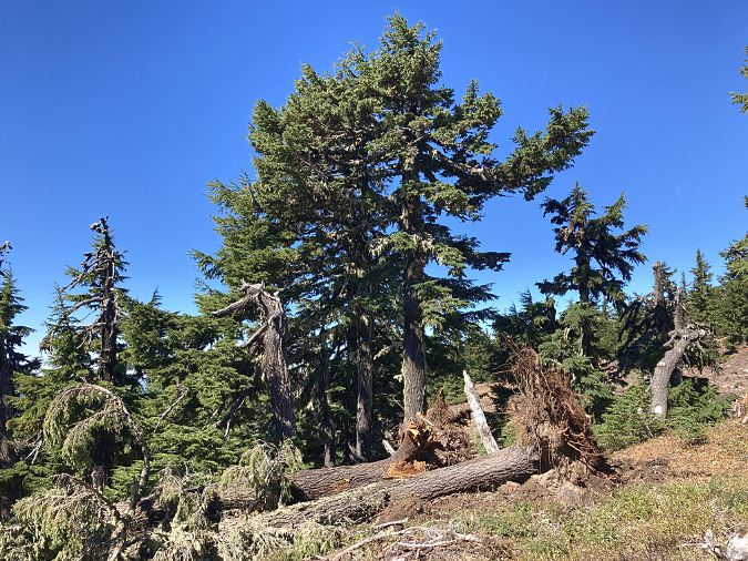
Tipped trees are a common sight in our forests, and they help tell the story of how wind is shaping the ecosystem. This old-growth tree (below) was among the largest in a mix-aged stand of mostly younger trees, and it demonstrates what scientists have observed: big trees are often the primary victims of wind events in healthy, mix-age forests.
This old tree’s demise is already giving rebirth to the forest. It’s upturned root ball and the cavity it created in the forest floor have already begun to be colonized by ferns and other understory plants after just one year, thriving in the bright spot of sunlight created by the fallen giant. The tree, itself, will continue to provide habitat for decades to come as it decays on the forest floor.
The root ball on this tipped Douglas Fir is beginning to decompose, leaving nutrient-rich soil newly exposed for new understory plants to take root
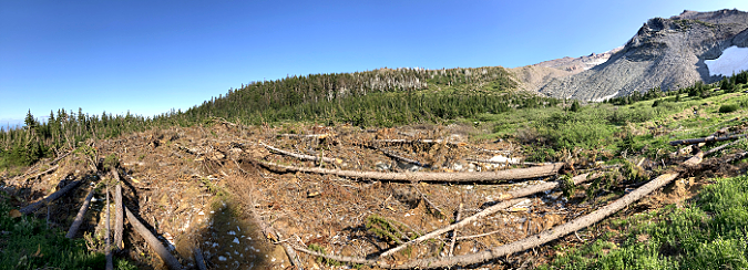
Small forest openings are one of the most important contributions of blowdown events. These scenes (below) are from a small blowdown area on Mount Hood that resulted from the 2020 wind storm. While seeing big trees toppled and broken is unsettling, the response of the understory after just two growing seasons to the sunlight provided by the new forest opening is equally inspiring. New life flourishes in these openings, where deer have abundant, new browse and other wildlife species thrive in the lush, rejuvenated understory. Soon, young conifers will take hold here, beginning the forest cycle, once again.
Small blowdown areas like this one along McGee Ridge area boon to forest health, allowing the understory to flourish in the new sunlight and young conifers to become established
Beneficial forest opening created by the 2020 blowdown event along McGee Ridge
It’s easy to forget that most small forest openings like the one shown above don’t just happen, they are usually created by wind events and blowdown. That’s because the evidence of the blowdown is so fleeting. Soon, the fallen trees in this blowdown area will disappear into the understory. Their limbs will fall away as they begin to decay, and their trunks will be pushed to the ground by gravity and winter snowpack, eventually becoming invisible to hikers passing by. Yet the effects of this blowdown event has created a forest opening that will endure for decades to come.
Fallen trees can last for a century or more in our forests, especially large trees. Eventually, however, they decay into a long, deep pile of mulch that becomes a nursery for understory plants and conifer seedlings. This is common on the western, rainforest side of the Cascades, where these are known as “nurse logs”. The first example (first two images, below) jumps out because a hiking trail happens to run parallel to the nurse log. The second example (third image) shows a nurse log still spanning a stream, even as it hosts a new forest of young conifers.
In Oregon’s west-side rainforests, downed trees eventually become “nurse logs”, with young trees growing along their length as the log decays and blends into the soil. This log happens to form the border of a hiking trail
This is the same log in the previous photo as viewed in the opposite direction to show the trees growing atop this decaying “nurse log”
Nurse logs often span streams, as in this case on Tag Creek in the Clackamas River area (lower part of this image). Eventually, this log with buckle and fall into the creek, though some of the Western Hemlock seedlings growing on it will likely survive to continue growing along this stream
It’s easy enough to spot fallen logs in our forests and to appreciate the role of wind in creating forest openings or stream habitat. But one of the less obvious benefits of blowdown might be the most important – the role that wind plays in creating multi-aged, biologically diverse forests. When you find yourself in a multi-aged stand of trees ranging from ancient old growth to seedlings, you’re seeing centuries worth of alternating wind and fire events at work, gradually culling both the forest understory and overstory over time. The result in the Pacific Northwest are forests with a sheer biomass and ecological diversity that is unrivaled in North America.
The following scenes show mixed-age, mature forests shaped by wind and fire. In each case, the conifer overstory ranges from old-growth giants to mid-sized and younger trees. Bleached snags, downed trees and young conifers emerging from the understory mark a new opening created by blowdown.
Healthy conifer forests have multi-aged stands of ancient, mature and young trees with standing snags, like this forest on the slopes of Bald Mountain, near Lolo Pass
Healthy, multi-aged conifer forest on the slopes of Bald Mountain
The previous images (and the one below) were captured along the Top Spur trail, on Mount Hood’s west side. While most hikers pushing up this popular trail have their attention focused on popular destinations like McNeil Point, the forest along this short trail is among the best examples of a multi-aged, subalpine stand on the mountain. It was very nearly logged, too – the name “Top Spur” refers to the logging spur that now forms a crowded summer trailhead instead of the log landing that once operated here. Today, it is protected as wilderness.
Multi-aged Noble Fir forest in winter on Bald Mountain
Noble fir giants dominate the forest along the Top Spur trail, but you will also find Western Redcedar along the tiny stream that runs through the area. Where fallen logs have been sawed out to keep the trail open, count the rings – you’ll find that even the trees that are 12” in diameter are more than a century old in this challenging, subalpine environment. The largest trees have been growing here for several centuries, and are living witness to the succession of storms and fires that have shaped this thriving forest. And while hikers may curse the tangle of roots exposed on this well-traveled trail, they tell a story of a mountain slope that is quite literally held together by the lush conifer forest that is thriving here.
Want to see this forest? It’s a short hike from Top Spur to the site of an old forest lookout on Bald Mountain that begins in this beautiful old growth forest, then climbs through a very young forest where “Bald Mountain” is a bit less bald (ironically, thanks to fire suppression aided by the former lookout).
Moonrise over Mount Hood from the top of Bald Mountain
The view of Mount Hood from the top is stunning and worth the short, often steep hike. Oh, and you’ll probably have to step over some blowdown, too… but hopefully with new appreciation! You can find a hike description here:
..and yes, you might recognize the author of that particular field guide entry…
______________
(Author’s note: as always, thanks for reading this far, and apologies are in order for my absence in recent weeks! I’ve got plenty of articles in progress, just lacking time needed to get them posted. I hope to get back up to speed shortly!)
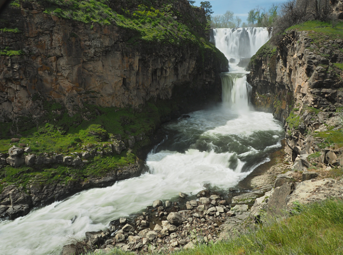
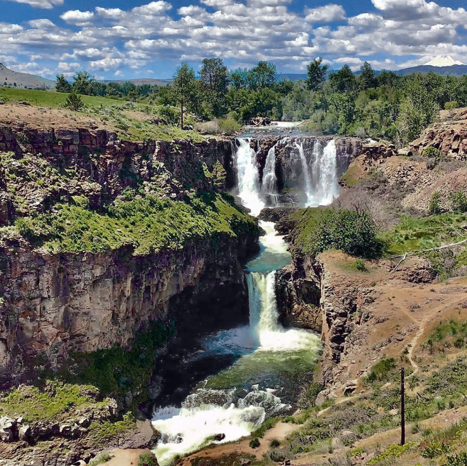
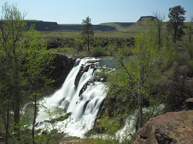
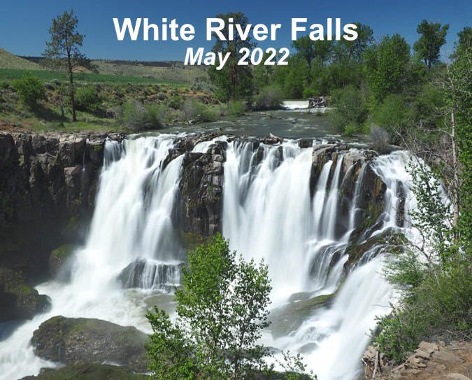
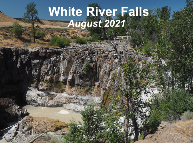
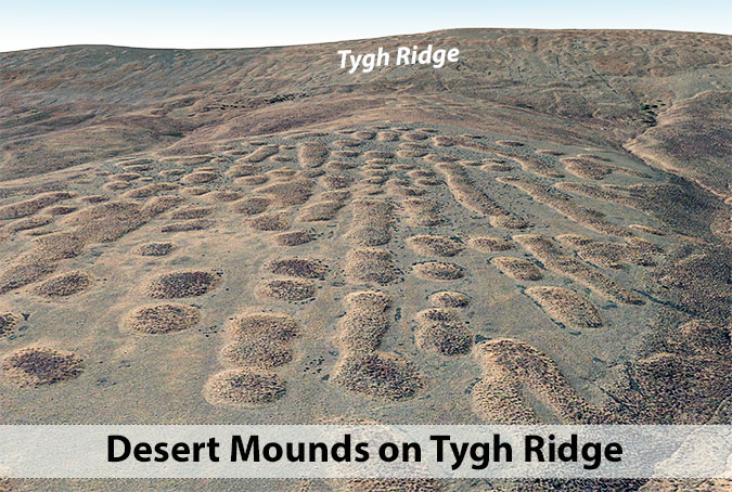
Every year, a growing number of summer visitors flock to White River Falls State Park to witness the spectacle pictured above, only to find a naked basalt cliff where the falls should be! The spring runoff has long since subsided by mid-summer, and field irrigation in Tygh Valley also draws heavily from the tributary streams that feed the river during the dry season. Worse, part of what’s left when this federally protected Wild and Scenic River finally reaches the park is diverted by a century-old waterworks into a side channel that bypasses the main falls. It’s a sad sight compared to the powerful show in winter and spring, but it doesn’t have to be this way.
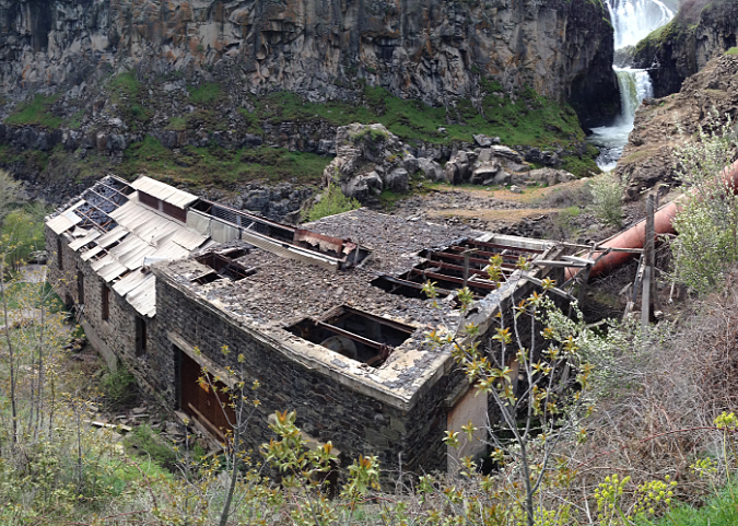
Many of these same visitors hike down to see the historic, century-old powerhouse at the base of the falls that once used the diverted river water to spin some of Oregon’s earliest hydroelectric turbines. Though mostly in ruins, the site is fascinating – yet the trail to it is a slick, sketchy goat path coming apart at the seams that hikers struggle with. This short hike doesn’t have to be this way.
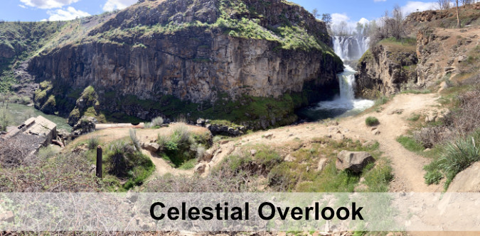
The hidden lower tier and punchbowl is called Celestial Falls
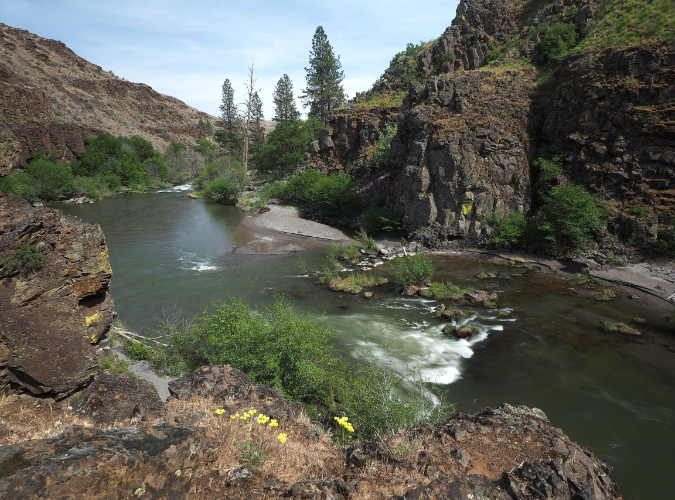
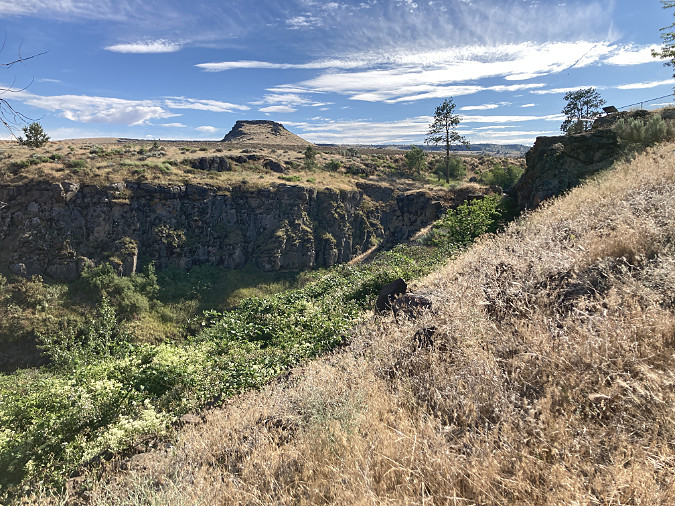
Lower White River Canyon
Some hikers push beyond the historic powerhouse to the lesser-known lower falls, and then still further, to a dramatic view into the lower White River canyon. Here, the river finally has carved a rugged path to its confluence with the mighty Deschutes, just a few miles downstream. It’s a striking and beautiful riverside hike, but the “trail” consists of a maze of user paths that are gradually destroying the drifts of wildflowers along the canyon floor. This trail doesn’t have to be this way, either.
Lesser-known Lower White River Falls
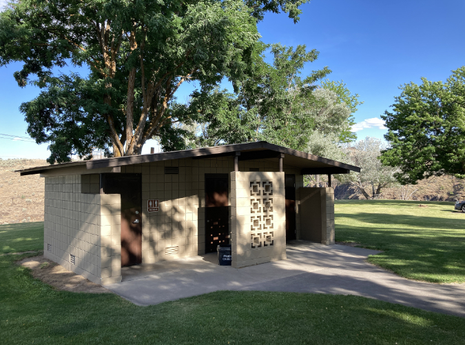
In recent years, White River Falls State Park has also become a popular stop for cyclists touring the route from Maupin to Tygh Valley, then looping back through the Deschutes River canyon. While the park has an excellent restroom and day-use picnic area that would make for a terrific stopover, overnight camping is not allowed, even for cyclists camping in tents. This, too, does not have to be this way.
The increased popularity has begun to noticeably wear on the park. The good news is that in the past couple years Oregon Parks and Recreation (OPRD) rangers and the park’s dedicated volunteer park hosts have stepped up their efforts to care for the park infrastructure and get a handle on vandalism (mostly tagging) that had plagued the historic powerhouse. Still, much more is needed to unlock the amazing potential this park holds as a premier destination. It’s time to reimagine White River Falls.
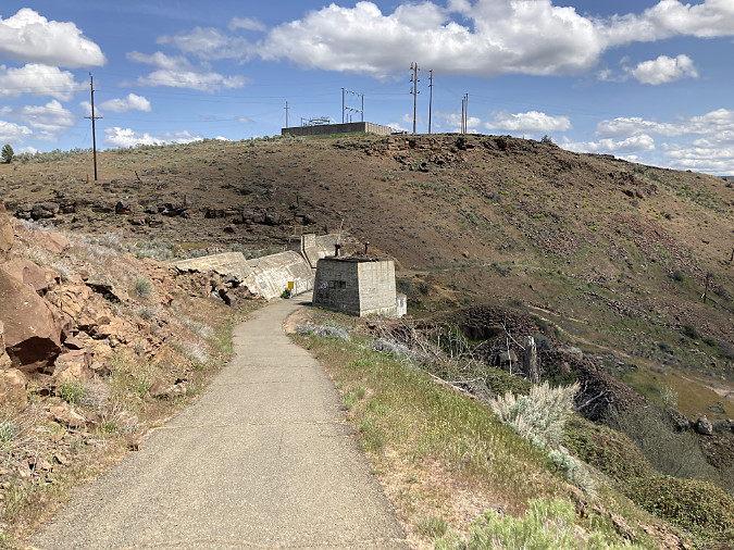
Historic White River Powerhouse just downstream from the falls
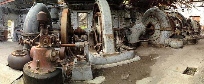
Turbines inside the powerhouse a few years ago, before vandalism began to take a heavy toll. Oregon State Parks has since closed off entry with heavy barriers
As it stands, the park lacks a comprehensive vision for how its natural and historic wonders can best be protected, while still keeping pace with ever-growing numbers of visitors. It’s a surprisingly big and mostly undiscovered place, and an updated blueprint could achieve both outcomes: protecting and restoring the natural and historic landscape for future generations, while also making it accessible for all to explore and enjoy. While the park includes a surprising amount of backcountry now, White River Falls also holds the potential to become a much larger park that restores and showcases the unique desert landscape and ecosystem found here.
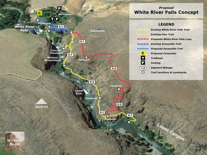
This article includes several proposals for new trails and campsites to better manage the growing demand and provide a better experience for visitors, expanding the park to better protect the existing resources, and even a re-plumbing of the waterworks to allow White River Falls to flow in summer as it once did before it was diverted more than a century ago.
An Unexpected Past
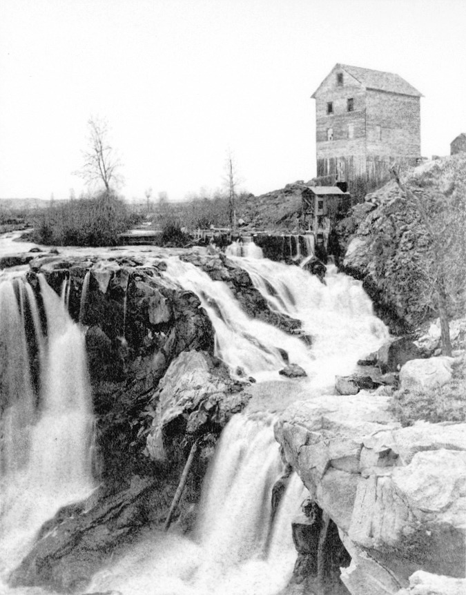
Grist mill at White River Falls in the late 1800s. This rare view reveals a northern cascading segment of the falls to have been part of the natural scene, and not created by the power plant diversion channel that was constructed in the early 1900s.
White River Falls was never envisioned as a park by the white migrants who settled in Tygh Valley and Wasco County in the mid-1800s. In their day, waterfalls were viewed mostly as obstacles to river navigation or power sources to run mills. The falls surely had a more spiritual and harmonious value to native peoples who had lived, fished and gathered along its banks for millennia before white settlers arrived. The Oregon Trail passed through Tygh Valley, and soon the new migrants had cleared the valley and began to build irrigation ditches to bring water to the cleared farmland. By the late 1800s, a grist mill was built at White River Falls, powered by the falling water.
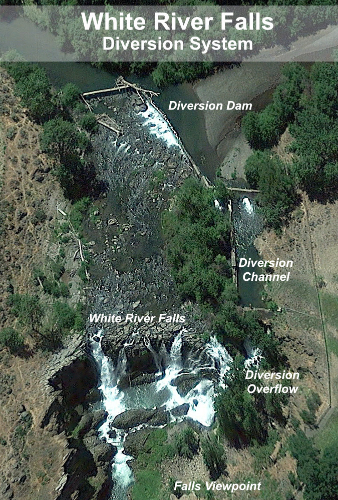
By the early 1900s, the grist mill was replaced with a much more ambitious project, and the abandoned hydroelectric plant we see today was constructed at the base of the falls in 1910. A concrete diversion channel was built where the grist mill stood, and a low diversion dam brought a steady flow from the White River into a series of pipes and penstocks that powered the turbines below. Power from the new plant was carried north to The Dalles, one of the earliest long-distance hydroelectric transmission projects in the country.
Aerial view of the White River Powerhouse and network of penstocks taken in the early 1900s. The group of structures at the top of the photo were located where today’s picnic area and restrooms are now. This photo also shows the concrete dam holding the settling pond, in the upper right. This structure still exists today. The diversion dam is partly visible at the left edge of the photo, with its diversion pipe leading first to the settling pond, then to the lower penstock pipe leading down to the powerhouse at the bottom of this photo.
The White River is a glacial stream that flows from a glacier by the same name on Mount Hood’s south slope, just above Timberline Lodge. Because of its glacial origin, the hydro plant included a large settling pond to separate the fine, grey glacial till that gives the White River its name. The settling pond still survives today (albeit dry), along with the diversion dam and much of the pipe and penstock system. These features are all visible in the aerial photo (above) and described in the interpretive schematic (below) provided by Oregon State Parks.
After fifty years of operation, the powerhouse had become obsolete and fallen into disrepair, and by the early 1960s it was abandoned. Giant new dams on the Columbia and Deschutes rivers had long since eclipsed it, and the constant chore of separating glacial sediments from the river water made it costly to operate.
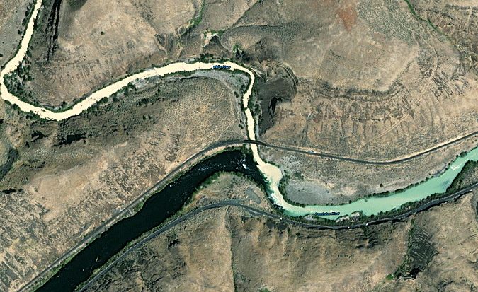
How white is the White River? This recent aerial view shows the White River flowing from the upper left corner toward its confluence with the Deschutes River, the wide, dark stream flowing from the lower left. When the crystal clear waters of the Deschutes mix with the silty glacial water of the White River during peak glacier melt in late summer, the result is a pale blue-green Deschutes River downstream from the confluence (flowing toward the middle right)
The site was an unlikely candidate for a new park, given the dilapidated buildings and pipelines scattered across the area. But thankfully, the raw power and beauty of White River Falls made the case for a second act as a public park and nature preserve borne from an industrial site. For many years, the reimagined White River Falls was simply the quiet “Tygh Valley Wayside”, and was way off the radar of most Oregonians. It only drew a few visitors and only the gravel parking area and main falls overlook were improved to a park standard.
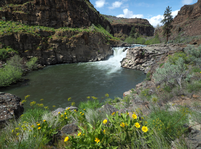
Panoramic view of Lower White River Falls during spring high water. The basalt bench to the left marks where flood events on the river have repeatedly overtopped this ledge, scouring the bedrock
The park had one (hopefully) final scare in its natural recovery just over a decade ago, when Wasco County pitched a new hydroelectric plant at the site, promising “minimal impact” on the natural setting. Thankfully, Oregon State Parks expressed major concerns and the proposal died a quiet death. You can read an earlier blog article on this ill-conceived proposal here.
Over the past two decades, growth in the Wasco County and increased interest from Oregon’s west side population in the unique desert country east of Mount Hood has finally put White River Falls on the recreation map. Today, the parking area overflows with visitors on spring and summer weekends, and the park has become a deservedly well-known destination. The rugged beauty of the area, combined with the fascinating ruins from another era make it one of Oregon’s most unique spots. These are the elements that define the park, and must also be at the center of a future vision for this special place.
A new vision for the next century: White River Falls 3.0
New & Sustainable Trails
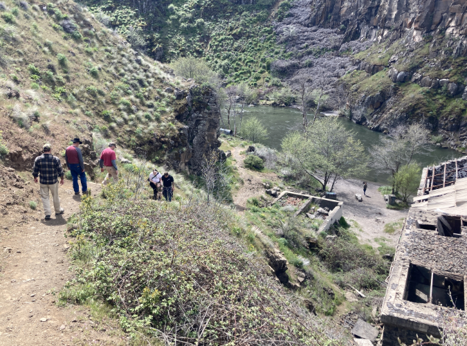
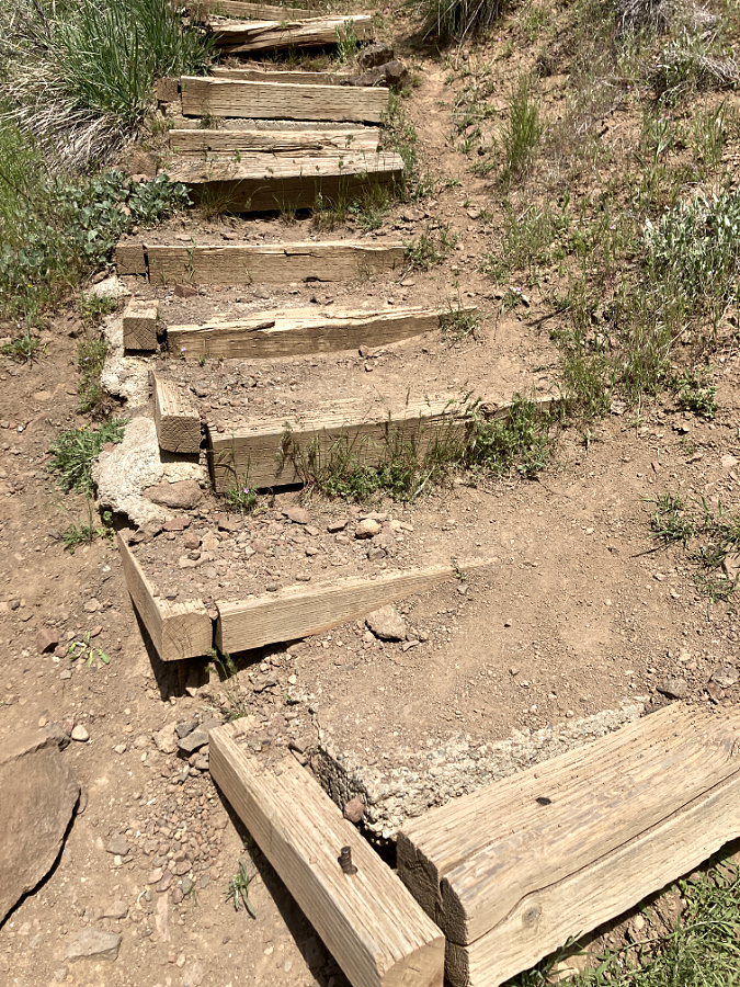
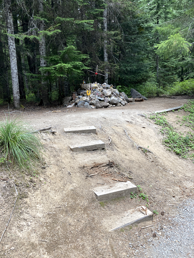
Weekend visitors skittering down the steep, slick path to the old powerhouse
The trail into the canyon as it exists today is deceptive, to say the least. It beings as a wide, paved path that crosses an equally wide plank bridge below the old sediment pond dam. Once across, however, it quickly devolves. Visitors are presented with a couple of reasonable-looking dead-ends that go nowhere (I will revisit one of those stubs in a moment), while a much more perilous option is the “official” trail, plunging down a slippery-in-all-seasons (loose scrabble in summer, mud in winter) goat path. Still, the attraction of the river below — and especially the fascinating powerhouse ruins – beckon, so most soldier on.
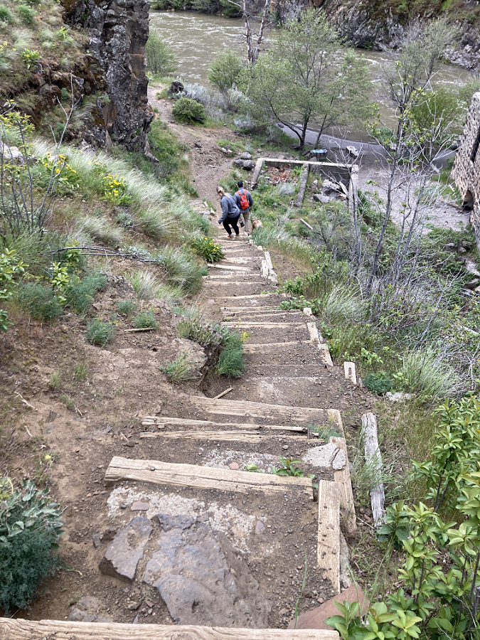
Soon, this sketchy trail reaches a somehow steeper set of deteriorating steps, built long ago with railroad ties and concrete pads. And still, the river continues to beckon, so most folks continue the dubious descent. The “official” trail then ends abruptly at the old powerhouse, where a popular beach along the river is a favorite wading spot in summer. This is the turnaround spot for most visitors. The return up the steps and scrabble of the goat path is challenging in any season, but it’s particularly daunting in summer, when desert heat reflecting off this south-facing wall of the canyon is blazing hot.
Hikers navigating the steep, deteriorating stairway section of the “official” goat path into White River canyon
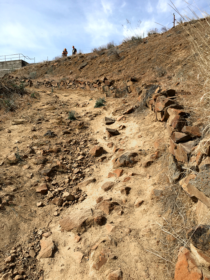
Looking back at the loose cobbles and scrabble that make up the upper section of the “official” trail into the canyon. Two hikers at the top of the trail consider their fate before continuing the descent
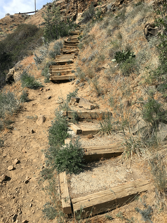
The stairway section has deteriorated enough that hikers are simply bypassing it, which is damaging the slope and causing the stairs to come apart still faster
The railroad tie steps were filled with poured concrete pads at some point, making this a very difficult repair job. In the long term, this section of the “official” trail simply needs to be bypassed with a properly graded route and the old goat path turned back to sagebrush
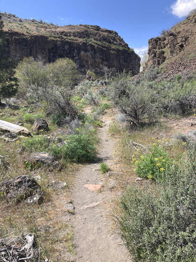
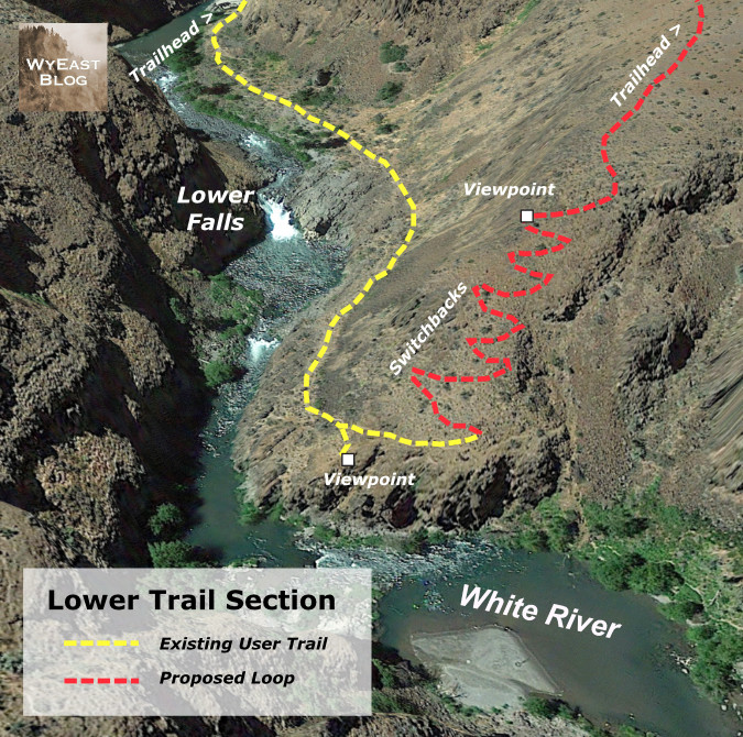
Beyond the “official” trail, a user path skirts a fenced river gauge, then slips through a patch of waist-deep sagebrush before dropping down to a beautiful streamside flat. Here, Ponderosa pine survive in the deep sand along the riverbank and rugged basalt cliffs soar above the trail. This path soon passes Lower White River Falls before ending at an impressive viewpoint looking downstream, where the White River tumbles another two miles through a deep canyon to its confluence with the Deschutes River.
The “unofficial” trail below the powerhouse was little known just ten years ago, but today it is quickly devolving into a tangle of user paths as an increasing number of visitors push further into the canyon. The flat canyon floor is quickly becoming a maze of these social paths, greatly impacting the desert wildflowers that grow here.
In contrast to the “official” trail, the lower “unofficial” trail rambles at a pleasant grade along various user paths through a beautiful canyon floor framed by towering basalt cliffs
After flying under the radar, the lower canyon has been “discovered”, with a maze of new social paths forming in the past few years that are gradually expanding and destroying the wildflowers that grow here
So, how to fix this? The first step is to improve both the “official” and “unofficial” trail sections to something resembling proper trails. The official route is a tall order, and in the long term, it really needs to be retired and replaced with a correctly graded trail that can be safely navigated and doesn’t trigger heart attacks for visitors making their way back out of the canyon. In the near term, however, simply repairing the damaged stairs and adding a few more in a couple of especially steep sections would buy some time until a better trail can be built.
The unofficial, lower trail is a much easier fix. It simply needs a single route with improved tread and modest stone steps in a couple spots, while also retiring the many braided user paths that have formed. The new interest in the lower trail underscores a more significant need, however, and that’s the main focus of this trail proposal: this hike is simply too short to be satisfying for many visitors.
The solution? Build a return loop from the current terminus of the lower, unofficial trail that traverses the canyon rim back to the trailhead. This simple concept is shown in the map, below.
The proposed return trail (shown in red) would be approximately one-half mile long, making the new loop about one mile in length – short enough for families and casual hikers, yet long enough to make for a more immersive experience. The loop would also allow hikers to avoid climbing back up the goat path section of the existing trail, buying some time until that segment can be rebuilt. The upper end of the proposed loop would actually follow the well-defined game path that many hikers assume to be the main trail where it now connects at the top of the “official” goat path.
Another surprise feature of the loop? The new route would not only provide spectacular views into the canyon and its waterfalls from above, but Mount Hood also appears on the horizon, rising directly above White River Falls. While most hikers would likely continue to first follow the existing trail to the old powerplant, then complete the new loop from there, the rim trail could also work in reverse for hikers looking for big views without the challenging up-and-back climb and steep steps on the existing trail. The upper end of the new rim trail would traverse at a nearly level grade to a spectacular viewpoint (shown on the map, above) that would be a fine turnaround destination just one-quarter mile from the trailhead.
One important detail of this trail concept that should be completed in the near-term is a formalized spur trail to the Celestial Falls overlook. This is an irresistible, yet extremely dangerous overlook just off the main goat path section of the “official trail”, with abrupt, vertical drop-offs and another maze of sketchy social trails.
The stunning overlook at Celestial Falls is a scary mix of ever-expanding social trails and abrupt vertical cliffs that needs near-term attention to be stabilized and made safer for hikers
Much of the new return trail would follow game paths (like this one at the upper end of the proposed trail) that already traverse above the rim of the canyon.
The new rim trail would bring hikers to this spectacular birds-eye view of White River Falls and Mount Hood on the horizon (Oregon State Parks)
The crux to completing the new loop is a short section of new trail that would climb from the current terminus of the “unofficial” trail to the rim of the canyon, where the new route would then traverse at a nearly even grade back to the trailhead. The crux section follows a sloped ridge through a gap in the canyon rimrock, as is shown in the close-up map (below).
The end of the user path in the lower canyon marks the start of the proposed new trail, where a set of switchbacks would ascend the slope to the left to the canyon rim and return to the trailhead
The crux section would require some switchbacks and thoughtful trail planning, but it is no steeper than the terrain covered by the “official” trail at the start of the hike. What would it take to make this trail vision happen? More on that toward the end of this article.
2. Accessible Trails
Did you know that rural Oregon has a higher percentage of elderly and mobility limited folks in its population than the state’s major urban areas? Yet, even in our most urban areas, Oregon is woefully short on accessible trails, and the gap is even greater away from major population centers. At White River Falls, there are building blocks for a new accessible trail system that could be phased in over time to become among the finest in the state.
The existing parking area is gravel and would need at least a couple paved spots to be considered accessible
This paved path starts (inexplicably) about 50 feet from the edge of the gravel parking area and leads to the fenced, main viewpoint (in the distance)
Currently, the parking area and initial approach to the main falls overlook is a combination of gravel and mowed lawn that falls short of an accessible. Just a short distance from the gravel parking area, a paved path leads to the fenced overlook of the falls, where interpretive signs tell some of the unique history of the area. It wouldn’t take much to make this viewpoint fully accessible.
The wide plank bridge that crosses below the old settling pond dam (left) and marks the east end of the paved trail system at White River Falls. The “official” goat path down to the old powerplant begins at the far end of the plank bridge
From the main viewpoint, paved routes head off on two directions. The wide, gently sloping main route heads east, across the plank bridge and then ending abruptly where the goat path section of the main trail begins. Like the main viewpoint, this section could be curated to make the terminus at the bridge more interesting as a stopping point, including history of the concrete settlement pond dam that rises directly above the bridge and some of the penstock pipe remains that still survive here. This is also the point where signage marking the hiker trails ahead is sorely needed – including some cautions about the state of the goat path trail.
The west end of paved trail system ends here, at a profile view of the falls
Another paved trail spur heads west from the main viewpoint, along a fenced cliff to a fine profile view of the falls. The pavement ends here, and a user path continues along the fence to a view of the diversion canal that once fed river water into the old hydro plant. This section of the paved trail system is somewhat narrow and uneven, but it could also be improved with some relatively minor work, including improving the surface and creating a more intentional viewpoint of the falls.
From the end of the paving, the fencing continues west to a view of the diversion channel (center)
New interpretive signage could also be added here to tell the story of this part of the park, since this is where the original grist mill also stood. The views here include Tygh Valley, and new signage could also describe the natural history of the White River and the native peoples who lived here before white migrants settled in the area.
Profile view of White River Falls from near the end of the paved section of the west spur. This is a fine viewpoint that could be improved to be a more accessible destination with interpretive stories about the surrounding area
Oregon State Parks has provided picnic tables at the main viewpoint in the past, but to make the existing paved routes more accommodating as accessible trails, several benches along the way would be an important addition. This is perhaps the most overlooked feature on accessible trails, yet they are especially important in a hot desert environment. The National Park Service sets the standard on this front in their parks across the American Southwest, where resting spots are prominent on all trails, especially where a spot of shade is available.
Thinking more boldly, a new accessible trail spur could be added along the nearly level grade below the main viewpoint that once carried water in huge steel pipes. Most of the pipes are gone, but a few remain to tell the story of the old power plant. This grade leads to a front-row view of the main falls that is close enough to catch spray during the spring runoff. It’s also an area where park visitors chronically (but understandably) ignore the many “AREA CLOSED” signs to take in this spectacular view.
Fences and warning signs are no match for these Millennials, but they are right about the view: this lower viewpoint ought to be a spot that more people can enjoy
In this case, the scofflaws are right: this viewpoint ought to be open to the public, and an accessible trail spur would expand that to include all of the public. This proposed accessible spur is shown as the dotted blue line in the trail concept map (above).
Looking east along the existing paved spur to the settling pond dam and plank bridge; the proposed accessible spur trail to the lower falls viewpoint would follow a well-established bench that once held penstock pipe (now covered in blackberries in the lower right)
Another view of the proposed accessible trail spur from the plank bridge, looking west, and showing the blackberry-covered bench that the trail would follow. White River Falls is just beyond the rock outcrop in the upper right
There’s are chunks of penstock pipe along this route, and maybe these could become part of the interpretive history? This entire spur trail concept is possible only because the grade was blasted from basalt for the penstock pipes, which is a great way to connect the industrial history of the site to the park that exists today. From the lower viewpoint, those folks who we rarely provide great accessible trail experiences for would be rewarded with an exhilarating, mist-in-your-face view of White River Falls.
3. Walk-in Campsites
The word is out to cyclists that White River Falls is a perfect lunch spot on touring loops from Maupin and Tygh Valley. The restrooms were recently upgraded, the water fountain restored to include a water supply for filling bottles and there are plenty of shady picnic tables under the grove of Black Locust and Cottonwood trees that surround the parking and picnic areas.
A growing number of these cyclists are “bikepackers” camping along a multi-day tour, often starting from as far away as Portland, and there’s new interest in bike-in campsites for these folks. Unlike a traditional car-camping format, these campgrounds require only a network of trails and simple tent sites with a picnic table.
The modern restrooms at White River Falls State Park have been recently renovated to be accessible and are in top condition
This newly restored water fountain has a handy spigot on the back for filling water bottles (and dog dishes, as seen here)
The park has a nice spot for exactly this kind of campground just to the west of the parking lot and picnic areas. Today, it’s just a very large, mowed lawn that slopes gently toward the White River, with a nice view of Mount Hood. Creating a bike-in campground here wouldn’t take much – no underground utilities or paving would be required, just some paths and graded camp spots. The park already has on-site hosts living here from spring through fall to keep an eye on things, and that coincides with the bicycle touring season.
The wide west lawn adjacent to the main picnic area (marked by the group of trees) at White River Falls State Park
Looking toward the west lawn (and riparian Cottonwood groves, beyond) from the picnic area
Perhaps most important would be to add some trees to shade this area. Right now, the west lawn is blazing hot in summer, so more of the tough, drought-tolerant Black Locusts that grow in the picnic area could provide needed shade without requiring irrigation. Even better, our native Western Juniper would provide some shade, as well as year-round screening and windbreaks.
4. Bringing Back the Falls
From roughly mid-July until the fall rains kick in, a visit to White River Falls can be a bit deflating. Instead of a thundering cascade, the main face of the falls is often reduced to a bare basalt cliff.
White River Falls in full glory during spring runoff
White River Falls by late summer, when most of the flow diverted away from the falls by the old waterworks system
Why is this? In part, seasonal changes in the river from spring runoff to the summer droughts that are typical of Oregon. But the somewhat hidden culprit is the low diversion dam that once directed the White River to the penstocks that fed to the old powerhouse. The hydroelectric plant is now in ruins, but during the dry months the diversion dam still pushes most of the river into a concrete diversion channel, which then spills down the right side of the falls.
The entire flow of the White River was channeled through the diversion channel on this summer day in August 2021. At this time of year, the glacial silt that gives the river its name is most prominent
The entirety of the diversion system is now a relic, and the old dam should be breached. There are more than aesthetics involved, too. White River Falls creates a whole ecosystem in the shady canyon below, with wildflowers and wildlife drawn to this rare spot in the middle of the desert by the cool, falling water.
The earlier image of the original grist mill shows that a side tier of the falls always existed, even before the L-shaped diversion dam was built. However, as this aerial schematic (below) shows, the natural flow of the river is straight over the falls, not over the side tier.
The diversion system at White River Falls is simple. The low, L-shaped dam at the top of this aerial view directs water to the concrete diversion channel at the right. From here, river water once flowed into the metal penstock pipes and on to the hydroelectric works, below. Today, the diversion channel simply flows over a low cataract and back into the main splash pool of White River Falls. In this view, the river was high enough for water to still flow over the diversion dam and then over the falls, but by mid-summer, the dam diverts the entire river into the side channel, drying up the falls.
I have argued for restoring waterfalls to their natural grandeur before in this blog, and in this case the same rule applies: nature will eventually remove the diversion dam, but why not be proactive and do it now? Why deprive today’s visitors the experience of seeing the falls as it once was?
5. Thinking big… and bigger?
In an earlier article I imagined a much larger desert park centered on White River Falls. Just 100 miles and about two hours from Portland, it would become the most accessible true Oregon desert experience for those living on the rainy side of the mountains.
That possibility still exists, thanks to several puzzle parts in the form land owned by the Oregon State Parks and Oregon Fish and Wildlife (both shown in purple on the map, below) and federal Bureau of Land Management (shown in orange) along the lower White River and its confluence with the Deschutes River.
There’s a lot of private land (shown in yellow on the map) in this concept of an expanded park, as well, most of it held by about a half-dozen land owners. Such is the nature of desert land holdings, where typical ranches cover hundreds (if not thousands) of acres. Why did I include these areas? Because area surrounding White River Falls includes one of the least-known and most fascinating landscapes in WyEast Country, and it that warrants long-term protection and restoration.
Most notable is the ancient river channel to the south of the White River Falls that I’ve called “Devils Gulch” for lack of a proper (and deserved!) name, as it is adjacent to a pair of basalt buttes called Devils Halfacre. This dry channel was formed by a massive landslide along the south wall of Tygh Valley that is nearly five miles long and more than a mile wide, and has likely been moving for millennia. The landslide may have begun as a single, catastrophic event, then continued for move slowly over the centuries, eventually diverting the White River north to its current route over White River Falls. I’ll be posting a future, in-depth article on this amazing geologic feature in addition to the following photos and caption highlights (and if any geoscience graduate students are reading this, we could use research in the form of a thesis on this area!)
This is the fascinating view across a massive, jumbled landslide and into the former canyon of the White River before it was diverted by the landslide. Today, the river flows beyond the two flat-topped buttes known as Devils Halfacre, in the upper left corner of this photo, diverted from the dry “Devils Gulch” valley at the center of this photo
This is a closer look at the two buttes known as Devils Halfacre. They once formed the north side of the ancient White River canyon, but the debris in the lower third of the photo diverted the river north sometime in the distant past. Today’s White River flows where the ribbon of Cottonwoods marks the valley floor, beyond the two buttes. White River Falls is behind the larger butte in the center. Snowy Tygh Ridge is in the distance
Below the landslide, the floor of the ancient White River canyon is fully intact. Beyond these dry meanders where a river once flowed is today’s White River canyon, marked by the canyon wall in the upper right of this view
This view of the east end of the landslide shows distinct rows of basalt debris formed by the landslide known as transverse ridges. These ridges form perpendicular to the direction of flow, in this case from the cliffs in the upper right that formed the source of the landslide toward what was the ancient path of the White River, in the lower left
Basalt rimrock is a common sight in Oregon’s sagebrush country, but in this case, the cliffs are a scarp resulted from a massive landslide event, not gradual erosion
This view from just below the landslide scarp looks north, toward Tygh Ridge, and across more than a mile of landslide debris now covered in sagebrush and desert grasses. The landslide covers roughly the bottom two-thirds of this photo
Looking west along the landslide scarp, Mount Hood and the Cascades rise on the western horizon
Another mostly forgotten feature in this larger park concept is a 1.5-mile section of old Highway 197 that was bypassed in the 1950s when the modern route was constructed. Because the desert does a fine job in preserving things, this piece of old road looks as if it were closed yesterday, not a half-century ago. While much of the historic road was destroyed by the modern highway, this section provides a view-packed tour of the Tygh Valley landslide from this graceful old road, including views into Devils Gulch.
The original highway from The Dalles to Maupin curved with the landscape, as compared to its 1950s-era replacement that used cut-and-fill design to make modern highways straighter and faster. This long-bypassed section of the old road is where the historic highway remnant makes a dramatic descent into the Tygh Valley. Surprisingly, even the painted centerlines still survive after more than 60 years of being abandoned!
Mount Hood rises above the highway for much of this lost highway, as well. If you simply enjoy following old routes like this, it’s a resource in its own right, but it could also be an excellent jumping-off point for hike or bike trails in an expanded park. Like accessible trails, mountain bike trails are lacking in Oregon, especially on the dry east side of the Cascades. For cyclists touring Highway 197, it could be an excellent, traffic-free alterative to a steep section along the modern highway alignment.
Cracks in the old paving are quickly discovered by moss and grasses. After making a sharp turn in its descent into Tygh Valley, the surviving section of old road points toward Mount Hood for much of its remaining length
Hundreds of mysterious desert mounds dot the slopes of Tygh Ridge, including large swarm along the north rim of the White River Canyon, downstream from the falls
Finally, there are flat-topped bluffs above the White River gorge (one that I’ve called the Tuskan Table, others north of the river) that have never been plowed, and still hold desert mounds – another topic I’ve written about before. Left ungrazed, desert mounds function like raised wildflower beds, providing both wildlife habitat and a refuge for native desert plants that have been displaced by grazing.
This is private land, so I haven’t ventured to these spots along the White River rim, but there’s a very good chance they are home to a threatened wildflower species that grows here and nowhere else in the world – the Tygh Valley Milkvetch. Scientists have documented the greatest threat to this beautiful species to be grazing, and therefore the importance of setting some protected habitat aside for these rare plants as part of the larger park concept.
Tuskan Table is a stunning, flat-topped peninsula of basalt that separates the Tygh Valley from the Deschutes River. In this view the table forms the west wall of the Deschutes Canyon. The White River joins the Deschutes just beyond Tuskan Table, in the upper right of this view
As the name suggests, the beautiful and extremely rare Tygh Valley Milkvetch grows only here, and thrives in several of the areas proposed as part of the larger White River Falls park concept (photo: Adam Schneider)
It turns out there is quite a bit of movement toward expanding park and wildlife lands in the lower Deschutes area. A few miles to the north, the Oregon Department of Fish and Wildlife has acquired several thousand acres in recent years along the north slopes of Tygh Ridge, where a series of side canyons and ravines drop into the Deschutes River.
The federal Bureau of Land Management has also been expanding its holdings to the south, along the Deschutes River, and upstream from Tygh Valley, where the White River flows through a deep basalt canyon. In both cases, these acquisitions have been through willing seller programs, often made possible through the federal Land and Water fund for public land purchases.
Making White River 3.0 happen..?
After some lean years in the 80s and early 90s, Oregon’s state park system has seen relatively stable funding thanks to a dedicated stream from the Oregon lottery approved (and later re-upped) by voters. This has allowed the state to open the first new parks in decades – Stub Stewart in the Portland Area and Cottonwood Canyon on the John Day River. Other parks have benefitted, too, with major upgrades at iconic spots like Silver Falls State Park. So, a refurbishing at White River is certainly within reach, if not a current priority.
Rugged canyon country in White River Falls State Park
The first step is a new park master plan. This is the document that guides park managers and volunteers toward a common vision and it is created through a planning effort that includes the public, area tribes and others interested in the future of the park.
What would a new master plan look like? It might include ideas from this article, along with other ideas for accommodating the growing interest in the area and the need to actively manage the visitor impacts that are becoming visible. It would likely include plans to do nothing at all in places that should remain undisturbed, for ecological or cultural reasons.
Mostly, a new park plan for White River Falls should go big – not simply be a property management plan, but one that seeks to assemble a complete snapshot of the unique desert ecosystem that surrounds White River Falls through an expansion of the park. Cottonwood Canyon State Park is a fine model, as it was once a private cattle ranch, and is now being restored to its original desert habitat.
_________
“Make no little plans. They have no magic to stir men’s blood and probably will not themselves be realized. Make big plans, aim high in hope and work, remembering that a noble, logical diagram once recorded will never die, but long after we are gone will be a living thing, asserting itself with ever growing insistency” (Daniel Burnham)
_________
Once a park master plan is in place, new trails are the easiest and most affordable first step, especially in desert country. Much of what I’ve described here could be built by volunteer organizations, like Trailkeepers of Oregon (TKO). A new tent campground might be as simple as grading and adding water lines, also a manageable cost.
The White River has carved a deep gorge into hundreds of feet of Columbia River Basalt below the falls
Acquiring land for a greatly expanded park? There are plenty of tools and funding sources for this, but the first step is a vision described in a park master plan. The partners in making it happen would be public land agencies who already have holdings in the area, including Oregon State Parks, Oregon Department of Fish and Wildlife and the BLM. Tools for making it happen could range from outright purchase from willing sellers to conservation easements and wildlife easements.
While researching the area, I discovered that a private, California-based hunting club has already leased hundreds of acres of private land within the expanded park concept for use by its members. Other land trusts may be interested in this unique area, as well, and could lead the way to an expanded park, as they have in other new parks in WyEast Country.
Winter sunset at White River Falls
And how about removing the diversion dam? This would be a more complex project that would probably require an environmental review, among other questions that would have to be answered. The actual removal is less an issue, as the dam is only a few feet tall and could easily be breached. Even without a plan for removal, the diversion dam is doomed. It hasn’t been maintained for decades and will eventually succumb to the wrath of the river. If we don’t remove the dam, the White River surely will!
I’ve written about the future of White River Falls in this article, but you don’t have to wait. You can enjoy it now! Here are some tips for visiting White River Falls:
_____________
• for maximum waterfall effect and the best wildflowers, stop by in late April and throughout May, but consider a weekday – the secret is out!
• bring hiking poles for the trip into the canyon – you won’t regret it.
• factor summer heat into your trip – the hike out of the canyon can be grueling on a hot August day.
• watch for poison ivy on the boot path below the main falls – the leaves are similar to poison oak, but it grows as a low groundcover, often around boulders that might otherwise look like a great sitting spot!
• make a driving loop through the town of Maupin and a section of the Deschutes Canyon from Maupin to Sherars Falls part of your trip.
• stop at the Historic Balch Hotel in Dufur and a walk down Dufur’s main street to Kruger’s Grocery on your return trip. It’s always important to support local communities when traveling through WyEast Country.
• finally, for Portlanders, stop at Big Jim’s drive-in at the east end of the Dalles for cool milkshake (and crinkle fries?) on the long drive home
_____________
Enjoy – and who knows? I might even see you out on the trail!
Workers cutting beams from solid pine trunks for the new Cloud Cap Inn during the summer of 1888. The (then) surging Eliot glacier loomed just beyond Cloud Cap in those early days (Author’s note: this is a modified historical image that I have colorized to bring the sense of the distant past a bit closer to our present-day world)
When the builders of Cloud Cap Inn began construction in earnest in early summer 1889, the backdrop for Mount Hood’s first mountain lodge was radically different than today. The Northern Hemisphere was experiencing the final decades of a brief, still unexplained cooling period known as the Little Ice Age that stretched from the 1500s through the 1800s.
The cooling was modest, but enough to surge the Eliot Glacier down to the tree line, nearly filling the deep trough between the high lateral moraines that were created in the last true ice age, thousands of years prior. The debris-covered terminus (or snout) of the Eliot Glacier was in plain view from Cloud Cap, directly behind the workers on the left side of the photo, above. It was formidable wall of glacial ice and rock rising nearly 300 feet above the valley floor.
Early photo views of the Eliot Glacier’s terminus shows the river of ice already receding between the 1890s and 1920s
The Little Ice Age faded in the 20th Century, and as the photo pair above shows, the Eliot Glacier was already receding from its recent surge by the 1920s. Today, the Eliot Glacier has retreated about a half mile from its terminus in 1889, and lost as much as half its depth to our warming climate.
The following photo pair shows the dramatic change from 1920 to 2020. The change in the glacier’s thickness can be seen by (A) the exposed cliffs below Cooper Spur were carved into a vertical wall by the glacier at its peak. The glacier’s terminus (B) has receded dramatically over the past century, revealing the high moraines we now see rising above the Eliot Branch. A more subtle change (C) are the alpine forests gradually moving up the mountain as summer snowpacks diminish.
Another, more detailed 1920 view of the Eliot Glacier’s terminus compared to the same view in 2020 shows the radical change over the past century
For much of the past century, these changes were gradual enough that only a few scientists and mountain climbers noticed the ongoing change. But since the turn of the millennium the pace of change has accelerated to an alarming rate as our climate warms.
This article documents this most recent period of change, over the two decades that span from 2002 to 2022, including how the landscape on the mountain, itself, as changed. The article focuses on the area around Cloud Cap and the Eliot Glacier, as viewed from the Cooper Spur trail, as this corner of the mountain has seen some of the most volatile change.
Why 2002 as a starting point? That answer has to do with technology, not climate change. That was the year that I began shooting with a digital camera. For someone who learned photography with a film camera (including plenty of spent time in the darkroom in the 1980s) the age of digital has been a revelation. Film and print paper was expensive, and while I have a lengthy archive of images going back to 1980, the digital era has allowed me to bring back hundreds of photos from a single trip to the mountain, where I might have captured a dozen during the film era that was rapidly winding down by the early 2000s.
Then and now – my 2002 pocket camera and 2022 digital SLR, along with the 2002 photos I hoped to re-create.
The result is enough archived images beginning in 2022 to create a fairly thorough then-and-now comparison of the Eliot Glacier and surrounding environment along the Cooper Spur trail. The 2002 images came from a Canon A50 PowerShot pocket camera, still one of the best digital cameras I’ve owned over the years. Not long after this trip in 2002, I added my first digital SLR to my camera collection, and I have long since retired my film cameras for good. The 2020 images were captured with an Olympus EM-10 digital SLR, my fifth digital SLR, and easily my favorite (thus far).
To re-create the images from that 2002 trip, I carried a folded-up, modern-day version of a film-era proof sheet from that earlier visit in my pocket on a hike up Cooper Spur last September. Along the way, I did my best to match the scenes as I had viewed them 20 years prior. Once home, I was able to assemble 19 pairs that were close though to allow for nearly identical side-by-side comparisons. I’ve also noted a few points of interest for each image, keyed to both the 2002 and 2022 versions, to help highlight the changes that have unfolded. Because the embedded images in this article are inherently small, I’ve also posted a link below each image to a large version that will open in a new tab.
And now, how about a tour of these places in 2002 and 2022?
From Cloud Cap, the Timberline Trail route to Cooper Spur makes a dramatic entrance to the upper section of Tilly Jane Canyon and the first big view of Mount Hood. The changes in the first photo pair (above) are subtle, though telling. As is the case throughout the Cascades, groves of (A) Mountain hemlock continue their march to higher elevations, one more indicator of our changing climate. Lighter snowpacks (which translates to longer growing seasons) might also be the explanation for more expansive groundcover (B) of Juniper and Penstemon in the foreground. In distance (C), a pioneering Whitepark pine has survived to grow from a few feet tall to nearly 20 feet.
Moving further up the mountain, the Timberline Trail reaches a junction with the Tilly Jane and Cooper Spur trails (above), just above the tree line. Here, the most notable change is the battering the old trail sign has taken in 20 years of winter storms and avalanches. The two signboards were still around as recently as four years ago, but they were finally swept away in the last couple years. The bottom of the 8×8” post remains, though it had snapped off mid-way several years ago — a reminder of the power of moving winter snow in this avalanche-prone area!
Just uphill from the trail junction, the next photo pair (above) shows a venerable Mountain hemlock that has caught the eye of many hikers over the years. Notably, the Whitebark pine just behind the hemlock (A) has grown considerably, a hopeful sign for a keystone species that has been hard hit by climate change and disease in recent decades. The hemlock (B) shows some wear, however. The upper limb that reached out toward Mount Rainier and Mount Adams has lost the battle with the winter elements, and some of the lower limbs seem to be fading, too. But in the timeless cycle of nature, a completely new Mountain hemlock (C) has grown from beneath its elder, no doubt helped along by nutrients from the decaying limbs of the older tree and the protection from the elements the old hemlock still provides.
Further up the trail, the old stone warming hut at Cooper Spur appears (above). These shelters were built by the Civilian Conservation Corps (CCC) in the early 1930s, when the Timberline Trail was first completed. Thankfully, almost nothing has changed here, thanks to the work of volunteers who keep this old structure cabled to the ground and intact after nearly a century.
Above the old warming hut, the Cooper Spur Trail heads into tundra country (above) as it nears the 7,000 foot elevation on the mountain. From this perspective, the retreat of the Eliot Glacier starts to become apparent, especially to those familiar with the area. The rounded ice crest known to climbers as the Snow Dome (A) is notably smaller and the depth of the glacier has receded enough in the lower reaches (B) to drop beyond the top of the east moraine from this perspective. In the foreground (C) alpine wildflowers continue their march to higher elevations where only a few grasses once grew because of once-lingering snowpacks.
This photo pair (above) is from the first big view of the Eliot Glacier from the Cooper Spur Trail. The change over the past 20 years is unmistakable here. On the upper shoulder of the mountain (A), the snowfields that once led climbers to the summit well into summer are much smaller, making this approach in summer a very sketchy affair today, with much falling rock.
This pair of images also shows how the lower Eliot Glacier icefall has changed dramatically in just two decades of glacial retreat. The blue chaos of seracs and crevasses (B) that were once a prime ice climbing destination are now well below the “firn line”, the point at which a glacier is losing more ice than it is gaining. This line is generally where a glacier changes from blue and white clean ice to a gray mix of ice and rock, as the glacier gradually shrinks and melts in its descent. Further down (C), the decreasing depth of the glacier is especially notable where blue and white ice have disappeared.
The next pair of images (above) is from an overlook just below the crest of Cooper Spur, at about the 8,000 foot elevation. Here, the Eliot Glacier is still impressive and awe inspiring as a mass of tumbling ice and wrinkled crevasses. The notable change in these views is the thinning of the ice (A and C) along the glacier’s margins, with piles of rubble appearing between lobes of flowing ice. The main icefall (B) also has some underlying rock showing as yet another sign of the thinning of the ice sheet
This pair (above) is simply a closer look at the main icefall from the same vantage point, showing (A) where the thinning ice mass has revealed more of the north wall of the mountain, and (b) where rock outcrops are now pushing through the icefall from below. Icefalls form because of these outcrops, so the appearance of the underlying rock is measure of the glacier depth decreasing. Twenty years ago, enough ice flowed over this outcrop to completely overwhelm it, whereas today we’re beginning to see traces of the rock beneath the glacier.
This is another view of the Eliot Glacier from just below the crest of Cooper Spur, looking across the upper part of the glacier. Here the shrinking snowfields on the climbing route above Cooper Spur (A) are more apparent, as are the exposed cliffs (B) below the north face of the mountain, where the thinning ice has revealed a vertical well. On the shoulder of the mountain, a once-crevassed section of moving glacier has slowed to become a snowfield along the margin of the glacier.
This photo pair (above) is looking across the Eliot Glacier from the crest of Cooper Spur, at about 8,500 feet elevation. It’s subtle, but the permanent snowfields (A) along the upper end of the Langille Crags are smaller today, and the lower icefall (B) is dramatically diminished, as shown in previous views. In the near distance (C) the silver ghost forest of the 2011 Dollar Lake Fire shows up today along the Mount Hood’s northern foot. In the far distance (D) the massive (and completely unsustainable) logging spree being carried out by timber giant Weyerhauser since taking over the timber holdings in the West Fork Hood River area a few years ago is painfully apparent.
This pair (above) is a closer view of the previous set, focusing on the lower Eliot Glacier icefall. This comparison shows the thinning of the ice sheet (A and B) against the cliffs of the Langille Crags, and (C) the dramatic change on the near side of the glacier, where the firn line has moved several hundred feet up the mountain over two decades.
Moving away from the Eliot Glacier, this photo pair (above) shows the broad east slope of Cooper Spur from the crest, looking toward the canyon of the East Fork Hood River. The changes here are subtle, but still notable. Historic Cloud Cap Inn (A) still stands, despite being threatened by both the 2008 Gnarl Ridge Fire and 2011 Dollar Lake Fire. The ghost forests of the Gnarl Ridge Fire (B) are recovering rapidly today, filled with understory and rapidly growing Western Larch seedlings that are now 6-8 feet tall. In the distance, the human scars (C) caused by Forest Service clear cutting on the slopes of Surveyors Ridge in the 1980s and 90s are gradually fading away, too, as the forests there slowly recover.
Happily, not much change at Hiroshima Rock (above) in 20 years – or even 122 years! This unlikely etching by a 1910 Japanese Climbing expedition has somehow survived more than a century of fierce ice and sand blasting, perhaps because the carving is on the leeward side of the rock? It remains a favorite touchstone for hikers passing through. Here’s an earlier blog article on this unique message from the past.
This photo pair (above) is looking back toward the crest of Cooper Spur from a bit further up the mountain, with a feature known as Tie-in Rock in the foreground. As in previous photos, the burn scars (A) of recent forest fires can be seen in the distance. The seemingly inescapable modern phenomenon of rock stacking (B) is present on Tie-in Rock, too. Size is hard to gauge here, but the rock is about 15 feet tall and takes some effort scale — much less with rocks in hand! The Newton Clark Glacier’s retreat (C) is somewhat noticeable on the far right, though the changes are much more apparent in the image pairs that follow.
This image pair (above) provides full-on view of the Newton Clark Glacier from Cooper Spur. This sprawling glacier faces southeast, and because it catches summer sun from sunrise until late afternoon, it is has been more visibly impacted by climate change than the northeast-facing Eliot Glacier. What was once an icefall (A) 20 years ago is now bare rock, with the glacier flowing around it. Along the margins of Cooper Spur (B and C) the shrinking expanse of the glacier is prominent.
This is a similar view (above) looking south across the Newton Clark Glacier. Like the Eliot Glacier, the lower, blue and white ice crevasses (A) on the glacier have fallen below the firn line, replaced by a grey mix of moving rock and ice. On the far shoulder of the mountain the former icefall at the center of the glacier (B) has receded around the rock outcrop that once produced it. In the foreground (C), the thinning of the overall ice sheet is dramatic over just two decades. Mount Jefferson is visible on the far horizon.
This photo pair (above) is from far below Cooper Spur, at an overlook above the Eliot Branch called Inspiration Point. I’ve included it in this series because the retreat of the glacier has had dramatic impacts downstream, too. As the glacier continues its retreat, the Eliot Branch is cutting a v-shaped channel into the soft, flat valley floor that was once beneath the glacier, releasing vast amounts of rocky debris into the stream below. Compounding that effect are periodic flood events that have repeatedly scoured the canyon. As this pair shows, the changes are extensive.
For reference, a grove of three trees (A) in the lower center of the above photo pair have dodged the mayhem, though a group just below this trio has been swept away by the Eliot Branch. Meanwhile, an entire stand of trees (B) on the west wall of the canyon has slipped away in a massive landslide, revealing raw, banded volcanic bedrock, below. Another stand of trees on the east side of the canyon (C) burned in the 2011 Dollar Lake Fire, as did the remaining trees (D) in the upper west side of the canyon. This continues to be a very active, dynamic area, with constant changes to the river channel and canyon walls.
The final photo pair is a longer comparison of just over 120 years, as seen from Cloud Cap Inn. Mirroring the changes shown throughout this article, the Eliot is a much smaller glacier today than it was when my own grandparents were born around 1900. The mass of ice and rock (A) that once made up the terminus would be enough to fill up much of downtown Portland. The lesser-known Langille Glacier (B) has almost certainly stopped moving, and has become a series of icefields. The Coe Glacier (C) is also in retreat, despite its shady location on the north side of the mountain.
Changes like those we are seeing on Mount Hood are tough to absorb, and thus I was determined to end this article on a hopeful note. Why? Because I’m a hopeful and optimistic person to the core, but also because there is much we can do to slow the climate change that is affecting so much of our world.
We’re not powerless against these changes, though we do have a limited time on this planet to do our part. And thus, the final image pair (above). Why, it’s me! In 2002 I was a 40-year-old with blond hair and a red beard. Fast forward to 2022 and… well, at age 60 there’s not much hair left and the beard has turned decidedly gray. Time is not on my side, to be sure, but there is plenty more I can do in my life!
The benefit of 20 more years of living is the knowledge that I can still hoof it to the top of Cooper Spur (if a lot more slowly — and feeling it more the next day, too!) and still see things I’ve never noticed before. In 2002 I was still just thinking about how I could help keep the century-old idea of a national park around Mount Hood and the Gorge alive. Two years later, I started the Mount Hood National Park Campaign website to put the idea into words and pictures (and yes, it does need an update!). Six years later, I started writing this blog to continue celebrating the future Mount Hood National Park. That’s something I can continue to do even when getting to the top of Cooper Spur is finally out of my reach!
At age 60 I know I can’t single-handedly stop the changes happening on Mount Hood and in the Gorge, whether it be from climate change to just the sheer growth in the number of people coming here. But age DOES bring the super-power of perspective that can only come from time and lived experience — and in my case, I’ve also got the photos to prove it! I’m able to put a face on those changes to help inspire caring and action toward a new vision for the future, one that focuses on sustainability and adaptation in the face of change. That’s the point of this article and the WyEast Blog, of course.
And what about the future..?
Throughout that day on Cooper Spur in September, I watched a group of young glacier explorers far below me, working their way through rock debris and over crevasses as they approached the main icefall on the Eliot Glacier. I took a few photos of the group along the way, and was thus delighted to run into them on their return to the trailhead that afternoon. I turns out they were students from Pacific University’s Outdoor Leadership Program, led by instructor Philip Friesen.
If the then-and-now photos of changes on Mount Hood are tough to look, this is where the real hopefulness in this article comes in. Phil’s program at Pacific is pointing a new generation of future leaders toward a life and careers in the outdoors that I believe will be transformational for many of the environmental challenges we’re facing today.
When I asked, here’s how Phil describes his program:
“I think the main thing to share with the world is that the students in our program focus on addressing systemic oppression and environmental issues while learning how to courageously lead others into the mountains, on rivers, and on the rock–we combine the joy of being outdoors in nature with the challenge of meeting some of our society’s biggest challenges.”
And there are many other educators like Phil out there helping young people of today turn their passion for the outdoors and their hunger to enact positive change into lifelong careers that will have a real impact in making a better world. As an old guy with only a few years left to do my part, I find this so inspiring and reassuring!
Phil Friesen (left) and his group of Pacific University students from the Outdoor Leadership Program are all smiles last September, even after a grueling climb up the Eliot Glacier!
Students in Phil’s program spend extensive time in the outdoors, learning how to hike, climb and kayak, so that they may be able to bring the outdoor experience to others over their lifetimes. This is the very best path toward conservation and sustainability, especially for our public lands. Only when we spend time there can we begin to feel the personal sense of ownership necessary to care for and protect these spaces in perpetuity.
I have great faith in what we have named “Generation Z”, and so does Phil. Young people majoring in Outdoor Leadership at Pacific are readying themselves for a life doing what they love, whether it be as a guide, ranger, naturalist or many other emerging careers in the growing outdoor industry. They’re also learning about the history of exclusion on our public lands, and the urgent need to remove barriers so that all Americans can enrich their lives in the same way that the most privileged among us already do. That hits home for them, too, as they are by far the most diverse generation in our history.
Phil plans to share these images with his students, most of whom were born around 2002, when I took that first set of photos. They will likely find them jarring, as they only know the Eliot Glacier of today, and may not realize how quickly it is fading away. But they have an abundance of passion for the environment, and I do think these photos will lend still more urgency to them in their commitment to make our world a better place.
The author getting his head straight in the shadow of mighty WyEast before heading home for another week in civilization (Photo by Andy Prahl)
The real power of the Outdoor Leadership Program – and this is true for anyone who spends time in the outdoors – is the cascade of reflections that immersion in nature fosters. No matter your walk of life, time on a trail, among the trees or through mountain meadows, ensures the perspective, peace of mind and hopefulness needed to make the rest of our busy lives more successful. I refer to as my mental health time, when I get my head straight before another week of Zoom meetings and e-mails. Phil’s students are learning this early on, and I’m certain it will be as restorative and rejuvenating in their lives as it is in mine.
Phil’s group was all grins after a grueling day climbing up a glacier. Such is life when you’re 20 years old! They don’t know it yet, but they are part of what could be the most consequential generation in our history. They have no choice but to grapple with enormous challenges that my own generation has so short on. But because I do get to spend a fair amount of time around today’s Generation Z, I’m more certain than ever that they are special. They are uniquely up for the challenge. Phil’s students are way too young to know this quote that has guided since childhood, but they are nonetheless embracing it like no generation has before them:
________________
“Unless someone like you cares an awful lot,
it’s not going to get better. It’s not.”
-The Lorax
________________
And a final note to Phil Friesen and his Outdoor Leadership Program students: Thank you for the great things you are about to do!
________________
Author’s postscript: My best to all who have followed this blog over these many years! I greatly appreciate the support and especially your passion and concern for the future of our WyEast Country. I have a bunch of new articles planned for the coming year and look forward to sharing them with you!
Mount Hood rises over the Western Juniper forests on the east side of the Cascades
One of the most startling features of the Cascade Range comes from the rain shadow effect the mountains have on approaching Pacific storms. Through a process known as “orographic lifting”, weather systems rolling in from the ocean are forced up and over the wall of mountains when they reach the Cascades. This lifting has the effect of wringing out moisture from the clouds, resulting in rainforests on the west side and deserts on the east side of the mountains.
The rain shadow effect it especially prominent in WyEast country, where the Cascade range is at its narrowest, just 50 miles wide, compared to more than 100 miles or more across in much of the range. In less than an hour traveling through the Columbia Gorge from Troutdale to Hood River, the landscape changes from deep rainforests where up to 140 inches of rain fall annually to the Ponderosa pine and Oregon White Oak forests of the east slope, where annual rainfall dips below 20 inches.
Western Juniper finally give way to desert grasslands and sage in the rain shadow of Mount Hood, where annual rainfall drops below 10 inches
In the extreme rain shadow of the Cascades, where rainfall dips below 10 inches annually, the big conifers that define our forests finally give way to a sagebrush, grasslands and a rugged desert tree, the Western Juniper. Long overlooked as “non-commercial” (meaning it is not easily harvested as saw logs), these scrappy trees have been flourishing over the past century on the desert plains and buttes east of the mountains.
Mount Hood has its own juniper forests, though they are less widespread here than elsewhere in Oregon’s high desert country. The reason for this is agriculture. Much of the rolling desert terrain east of the mountain has been cultivated for well more than a century, originally for intensive grazing, and today for highly productive wheat farming.
Western Juniper still thrives at Juniper Flat, taking hold wherever the ground isn’t actively plowed
Yet, there are still Western juniper stands sprinkled through even the most heavily cultivated areas, and as you move away from the farms and the lowlands of the Columbia River Basin — Western Juniper mostly grow above 2,000 feet elevation — there remain many thriving Western Juniper forests.
The most extensive of these is (appropriately) at Juniper Flats, located 25 miles to the southeast of the mountain, on a rocky tableland adjacent to the White River Canyon. This is typical Western Juniper country — cold, sometimes snowy winters and hot, very dry summers. The soils here are thin, resting on a bedrock of basalt. The few areas that can be farmed have been cultivated, but the rest of Juniper Flat is grazing country where Western Juniper flourish.
When Juniper Flat got its modern name from white settlers arriving on the Oregon Trail, it’s very likely the juniper forests here looked much different than what we see today. That’s because our juniper forests are on the move and expanding.
Botanists generalize juniper forests into three community types:
• Mixed forests – these are where Western Juniper are mixed with Ponderosa Pine, Douglas Fir and other big conifers on the margins of the mountain forest zone.
Large Ponderosa Pine anchor this mixed forest, surrounded by lighter green Western Juniper that take on a tall, slender form in mixed forests
•Juniper forests – these occur where Western Juniper dominates and the trees grow relatively close together, with a canopy that typical covers 10-20% of the landscape
Juniper forest on the march at Juniper Flat where these trees are recolonizing a fallow farm field
•Juniper savanna — where Western Juniper are widely scattered in desert grasslands and their canopy covers less than 10% of the landscape
Juniper are widely scattered across this savanna in the shadow of Mount Hood, along the west edge of Juniper Flat
Scientists have documented an exponential increase in Western Juniper growing in Oregon since the late 1800s, in many cases transforming former juniper savannah to become juniper forests. This was likely the case at Juniper Flat, and today it mostly qualifies as a juniper forest.
In a landmark report published in the late 1990s, the Bureau of Land Management (BLM) found that over half of Oregon’s juniper forests we established between 1850 and 1900. Still more startling is the spread of Western Juniper since the 1930s, when the first comprehensive assessment was made. At the time the BLM study was released in 1999, an estimated a five-fold increase in juniper forest coverage had occurred over the previous 60 years.
That number of Western Juniper in Oregon continues to increase today, though there is an upper limit for these trees. Their sweet spot is desert lands above 2,000 feet elevation and between 10” and 20″ of annual rainfall. They do not seem to spread much beyond these areas, and in Oregon they are now present across most areas that meet these criteria.
Western Juniper berries are a critical winter food source for coyotes, foxes, rabbits and many desert bird species. These are also the berries the Dutch famously learned to distill in the 17th Century to make gin (a word derived from the Dutch word “jenever” for juniper), and a craft distillery industry using these berries has emerged in Oregon
Western Juniper foliage is evergreen and made up of tiny, overlapping scale-like leaves that help these trees conserve moisture in their harsh desert habitat
Western Juniper bark is tough, shaggy and fire-resistant, allowing larger trees to survive moderate intensity range fires
Given their recent spread in Oregon, Western Juniper forests are also remarkably age-diverse when compared to the even-aged stands we often see with young conifer forests. A typical juniper forest contains a diverse range of trees, from young to old. These trees are tough survivors, with fully one quarter of Oregon’s juniper forests more than a century old, and over a third of these forests have century-old trees in their mix.
Why are Western Juniper forests spreading? One answer is lack of wildfire in the ecosystem over the past century due to human fire suppression. Another could be effects of climate changes that scientists are only beginning to understand. Still another is the parceling and residential development of our desert lands, and a shift away from farming and ranching, where juniper forests were routinely cleared or burned.
Most think of Nevada as the heart of Western Juniper country, but more than three quarters of Oregon falls within its range, and a good share of California, Washington is also prime habitat for these rugged trees
As desert survivors, Western Juniper have adapted in ways that help them out-compete with other desert plants. They have enormous root systems that can extend several times beyond the size of their crown, spreading up to two and half times the height of the tree in all directions, compared to most trees with root systems roughly proportional to the width of their crown. This helps explain the wide spacing of Western Juniper. Where our big mountain conifers often grown just a few feet from one another, juniper forests might have as few as ten trees per acre, thanks to their huge root systems.
Western Juniper crowns are also part of their competitive strategy. Their dense foliage is estimated to capture more than half the precipitation that falls upon them. Some of this is absorbed, some evaporates, but the net effect is less moisture making it to understory plants or the soil.
The small Western Juniper on the left will have to work hard to complete with its larger neighbor for water and soil nutrients. Juniper are highly efficient in their ability to gather and store moisture, out-competing other species and even their own seedlings to survive
Juniper root systems also out-compete the desert understory species that are most associated with juniper forests. These include several sagebrush species, Bitterbrush, Rabbitbrush and a few other hardy desert shrubs, along with desert grasses and wildflowers. This has emerged as a chief concern for the BLM, since this translates into impacts on the cattle industry that leases federal grazing allotments. Beyond the economics of cattle grazing (and more importantly), the loss of understory also has impacts that ripple through wildlife populations, as well.
Another concern with the spread of our juniper forests is the potential risk to private property and human life from wildfire. Western Juniper is adapted to fire, and large trees are likely to survive low-intensity fires, but they can also burn hot when conditions are right. If juniper forests have spread rapidly in Oregon’s deserts over the past century, human development in juniper country has spread still faster, placing tens of thousands of rural homes at risk to wildfire.
This BLM fuels reduction work removed about one third of the trees in this juniper forest – mostly larger trees. The cut wood and limbs are simply stacked and left to decompose. The goal is to mimic the effect of fire in maintaining and open forest and understory that might otherwise be pushed out by juniper
These concerns have led the BLM to carry out “fuels reduction” projects in juniper forests on federal lands in Oregon as early as the late 1980s. One approach is controlled burns, a practice used in other conifer forests to reintroduce wildfire to the ecosystem after a century of aggressive fire suppression. This method ideally leaves the largest junipers standing and thins out younger trees, and it has been used successfully throughout juniper country. However, fires sent intentionally continue to be a controversial practice, as evidenced by the massive New Mexico wildfires currently burning that were ignited by controlled burns. In the era of climate change, land managers will need to revisit “safe” seasons for using this tool or risk public backlash that threatens to ban the practice completely.
Another approach to “fuels reduction” is simply cutting down trees and leaving them behind as debris piles, as pictured above. This approach works where there isn’t enough understory to support a controlled burn, or where proximity to private property makes a controlled burn too dangerous. However, it’s also labor intensive compared to controlled burns and still leaves cut debris behind as potential fuel.
In areas where these approaches were employed in the 1980s and 90s, subsequent monitoring by the BLM slowed that young juniper were already colonizing burned or cleared areas within just five years. Therefore, so long as natural wildfires are suppressed in juniper country, techniques like these will be needed in perpetuity to maintain some semblance of a natural ecosystem and to protect human life and property.
This craggy old fire survivor is surrounded by young Western Juniper quickly colonizing a former burn
This points to the larger problem of rural over-development throughout the West that continues to encroach on our forests. We’ve created a perfect storm with fire suppression and sprawling that climate change is only escalating, with whole communities now facing the risk of being swept up in catastrophic fires.
In Oregon, strict land use planning has blunted rural sprawl since the 1970s, yet some of the impetus for statewide planning was the “sagebrush subdivisions” that were already underway when legendary Governor Tom McCall railed against them in 1973. Loopholes in county zoning codes have since allowed thousands more homes to be built in the deserts of Central Oregon, in particular. For these spread-out communities that already exist in juniper country, fire prevention campaigns are encouraging those living there to “harden” their homes against fire. Yet, if you spend much time in juniper country, you know that the vast majority of homes continue to be built with wood siding and most of the older homes have highly flammable composition roofing.
Many of these areas should never have been developed as home sites, of course. And as fires continue to consume whole communities in the West, there’s a good chance that cost of fire insurance or the inability to secure home loans might prevent simply rebuilding when fires in high-risk areas do occur. We’ve seen this play out in chronically flooded areas in other parts of the country, after all. The West is still coming to grips with the permanent reality of wildfire, however, and it’s unclear if we have the collective will to say no to development in fire-prone areas like our juniper forests.
Before farming, much of the juniper country near Mount Hood looked like this – open desert grasslands and scattered groves of Western Juniper. This remnant landscape at the edge of Juniper Flat, looking north to Tygh Ridge
Meanwhile, the juniper forests continue to spread and flourish in Oregon. The situation in Wy’East country is more complex, though: much of the historic juniper habitat east of Mount Hood was converted to agriculture long ago. Yet, today, some of that ground is going fallow, whether by economic realities in a global agriculture market, or because large farm parcels are being picked up by non-farmers, reverting to native plant cover. Some fallow land is being purchased for conservation purposes, either by public agencies or conservation non-profits. If these trends continue, we may see the juniper forests spreading in Mount Hood’s shadow, too.
There aren’t great trails or developed recreation sites in Mount Hood’s juniper forests (someday, hopefully!), as much of the area is in private hands. But if you like exploring rustic backroads, Juniper Flat and nearby Smock Prairie are scenic and rich with history. Dozens of abandoned homesteads and barns, a couple old schoolhouses and some fascinating pioneer cemeteries are sprinkled along the gravel roads that crisscross the hay fields and juniper groves. Juniper Flat is located immediately west of the community of Maupin and about 125 miles from Portland, along US 197.
Forests of Noble fir forests spread out to the horizon along the crest of Waucoma Ridge, just north of Mount Hood (Mount Adams in the distance)
We’re coming into another holiday season when millions of Americans will set up a Christmas tree cut in Oregon. There’s a good chance it will be a Noble fir, long prized as the most beautiful and durable of Christmas trees, representing about a third of the cut tree industry here.
There was a time when Noble fir grown as holiday trees were left in their natural state, which features elegant tiers of symmetrical branches and soft, deep green, upwardly curving needles. In recent years, Nobles grown for mass-market consumption have increasingly been sheared to produce a densely branched, unnatural thicket (acknowledging my bias, here!) in the same way that Douglas fir have long been cultivated in the Christmas tree trade. Still, the un-sheared Nobles remain the gold standard, and they sell for gold-standard prices at tree lots, too.
New grown emerging on Noble fir boughs
Noble fir cones
In Oregon, families also have the option of cutting their own Christmas trees at U-cut tree farms, a popular benefit of living in a region that produces millions of holiday trees for the nation. It’s also possible to cut your own tree on National Forest land, a tradition that dates back a century or more. Though more regulated today by the U.S. Forest Service, families looking for a more adventurous option than local tree lot can head up to designated areas on the mountain (typically powerline corridors or recovering clear cuts) and bring home their own cut tree.
The author at age 11 (second from left) with family and friends on a 1973 trip to Lolo Pass to cut Christmas trees. Noble fir were always the goal, but in those days of heavier mountain snows, simply reaching the Noble fir zone in December was an adventure!
Christmas trees are pretty much the extent of public knowledge of the noblest of our true firs. As the common name might suggest, noble fir is the largest of all true firs. Their name was given in the fall of 1825 by botanist David Douglas when he ventured into the high country above the Columbia River River Gorge, in the vicinity of today’s Cascade Locks. Though he wasn’t specific about the peak he climbed on the north side of the river, it is believed to be today’s Table Mountain. A few days later, he climbed to a high point on the Oregon side, most likely today’s Benson Plateau.
On this pair of climbs, he came upon magnificent, old-growth stands of Noble fir, and gave them their well-deserved name. While they are undeniably beautiful as young trees, old-growth Noble fir are a sight to behold. Like many of our Pacific Northwest conifers, these trees grow to be giants, with the largest on record reaching nearly 300 feet in height and nearly 10 feet in diameter.
Old-growth Noble fir forests near Mount Hood’s Bennett Pass
An ancient Noble fir giant towers above the surrounding forest canopy near Bennett Pass
Noble fir are also unique to the Pacific Northwest, with a range that extends from just above of Snoqualmie Pass in Washington south to the Siskiyou Mountains in Southern Oregon and the Trinity Alps region along the northern edge of California. In their southern extent, they are known to hybridize with California’s Shasta fir, a variety of the Red fir that grows in the Sierras and extends into the southern fringe of the Noble fir range.
Despite their willingness to grow in planted rows as farmed Christmas tree seedlings in the hot, dry summers of the Willamette Valley floor, Noble fir are a subalpine species. They typically grow at elevations of 3,500 feet to 5,500 feet, where they are long-lived and acclimated to the harsh winters of our mountains. Not surprisingly, they grow more slowly under these conditions, but they are tremendously adaptable, and often grow on very steep mountain slopes and exposed, rocky ridgetops.
Centuries-old Noble fir giant near Bennett Pass
Noble fir is a sun-loving pioneer species in our forests, quickly colonizing in burn areas to form pure, long-lived stands. Hike through one of the towering old-growth stands found in the high country of the Columbia Gorge or on the peaks surrounding Mount Hood, and you’re likely walking through an old burn, with the age of the trees as a good indicator of when fire last roared through, long ago. That’s because they are not only post-fire colonizers, but also highly susceptible to fire as mature trees, as they lack the protective bark of fire-adapted conifers like Ponderosa pine and Western larch.
This cycle of burn-and-rebirth in our Noble fir forests is on full display today on the north slopes of Mount Hood, where the 2011 Dollar Lake Fire burned through sprawling stands of subalpine Noble fir. These forests were almost entirely killed where the fires swept through, yet today, the forest recovery is already well underway, with young Noble fir seedlings leading the way among other post-fire pioneer species.
Ghost forest of Noble fir skeletons where the Dollar Lake Fire swept through a decade ago
Ancient Noble fir killed by the Dollar Lake Fire will provide wildlife habitat for many decades to come as a new forest grows here
Noble fir seedling emerging from the charred ashes of the Dollar Lake Fire
Meanwhile, across the Clear Branch canyon on the north of the mountain, the forests along the crest of Blue Ridge and at Owl Point (along today’s Old Vista Ridge Trail) are made up almost entirely of Noble fir that had colonized an earlier burn there, one that occurred sometime in the early 1900s. This pair of photos (below) from Owl Point shows how the foreground was burned and just beginning to recover in 1952, while 70 years later the scene is reversed: the forests along Blue Ridge and Owl Point have largely recovered, while the north slope of the mountain is just beginning its recovery from the 2011 Dollar lake Fire.
When our Noble fir forests are spared of fire and logging, individual trees can easily live up to 400 years. The oldest known Noble fir have reached 600 to 700 years, though trees of this age are exceedingly rare after more than a century of commercial logging in the Pacific Northwest.
In the early days of extensive logging, in the late 1800s and early 1900s, true firs were considered a lesser wood, so the timber industry marketed the massive, old-growth Noble firs as “Larch”. This explains two Larch Mountains in the Columbia River Gorge, one on each side of the river, and each the site of extensive turn-of-the-century logging in the early 1900s. The better-known Larch Mountain is on the Oregon side, and its broad, high elevation slopes provided a perfect habitat for Noble fir.
Loggers felling a massive Noble fir on Larch Mountain in 1905
By the early 1900s, the Bridal Veil Mill on the Columbia River had established an upstream sister mill in the heart of these Noble fir forests, where the trees were hundreds of years old, having been spared by fire for many centuries. The upstream mill was known as the Palmer Mill (and later, New Palmer Mill, after the first mill burned), and a road on Larch Mountain still carries its name.
Loggers carried giant Noble fir cut on the slopes of Larch Mountain to the New Palmer Mill on logging railroads. This scene is from 1905
Old-growth Noble fir logs were milled at the original Palmer Mill site on the north slope of Larch Mountain. This scene is from 1896, when logging of the virgin Noble fir forests there was in its heyday
Palmer Mill was attached to the main mill by a long flume that followed Bridal Veil Creek, and it was the hub for a massive logging enterprise on Larch Mountain that felled most of the virgin Noble fir forests. Huge logs were first sent to Palmer Mill on a branched system of logging railroad spurs, then milled into rough lumber that was floated down the flume system to the Bridal Veil Mill for finishing into construction grade lumber.
Today, all but a few traces of the Palmer Mill are gone, and many of the Noble fir forests on Larch Mountain are approaching 100 years in age. The area somehow dodged the 2017 Gorge Fire that swept through vast areas of the Gorge, burning through thousands of acres of Noble fir forests in the Gorge high country.
Noble fir in the age of Climate Change
Today, Noble fir country in the western Oregon Cascades is a checkerboard of clear cuts that mark the advent of National Forest logging that began on a commercial scale in the late 1940s. When these trees were cut, the catch phrase used to justify logging ancient forests was “sustained yield”, though sustained yield forestry never envisioned restoring ancient forests to their natural state. Instead, the management philosophy was to provide a continual supply of 60-100 year-old trees from plantations that could be repeatedly logged via a vast network of logging roads built in our forests from the late 1940s through the early 1990s.
When 7.5 minute USGS maps were created in the 1950s and early 60s, there were already thousands of clear cuts on Forest Service lands that showed up on the new maps as a checkboard in heavily logged areas like Mount Hood’s Blue Ridge (shown here). Many more clear cuts followed, and sixty years later, these clear cuts are often overcrowded plantations of conifers that the Forest Service is now thinning through new timber sales
Despite the early bias against true firs, the wood produced by Noble fir eventually came to be valued for being light and strong, and was used during World War II in aircraft, as well as more common construction uses in windows, doors and paper production. This led to aggressive logging in the later years of the commercial timber boom of the 1950s-90s, when lower elevation forests had already been logged over, and high-elevation Noble fir forests were increasingly targeted.
The Pacific Crest Trail follows the crest of this ridge near Lolo Pass, where heavily logged, high-elevation Noble fir forests have been slow to recover. These clear cuts are now 40-50 years old, and yet the stunted, crowded young plantation trees are still dwarfed by the groves of big, old-growth trees that were spared the chainsaw
Clearcutting on the steep, mountainous terrain where Noble fir grow was never sustainable, at least as measured in human lifetimes. The big, high elevation Noble fir forests sold off by the Forest Service were often hundreds of years old, with even the smaller-diameter trees well over a century old. There was never a chance to produce a rotating “crop” of trees at these elevations large enough to justify logging for generations to come, but that didn’t slow the rush to log these forests.
Instead, the logging boom finally peaked with the listing of the Spotted Owl and subsequent “timber wars” in the early 1990s, and it has never fully recovered, though some logging on our national forests continues today.
This Noble fir fell across the Timberline Trail recently, and was sawed out by trail crews. While it is only about 15” in diameter, a count of the annual growth rings revealed this tree to be over 160 years old, demonstrating how elevation and mountain conditions slow the growth of these trees
It’s easily to lose perspective on just how old the trees in our mountain forests really are. The above is a timeline of human events that unfolded since this tree took root as a Noble fir seedling on Mount Hood until a windstorm knocked it down in 2020. This tree is approximately 14 inches in diameter and 160 years old.
These stumps near Bennet Pass mark some of the oldest and largest Noble fir ever logged near Mount Hood, with some of these trees approaching 300 years old when they were cut. These stumps look like they might be a couple years old, with bark still intact. In fact, these trees were logged about 30 years ago, yet the Noble fir seedlings growing in this recovering clear cut are barely six feet tall
This is the same stump that appears in the foreground in the previous photo, with approximate dates according to tree rings. When it was cut, it has lived through more than a quarter of the first millennium.
The Bennett Pass clear cut (shown above) might look recent, given the intact condition of the stumps and the young Noble fir trees just getting established. Yet, this forest was cut nearly 30 years ago, as shown in the aerial photo pair (below). Thanks to its high elevation at over 4,000 feet, and resulting slow forest recovery, this logged area is still just beginning to reforest.
After nearly 30 years, this clear cut in an old-growth Noble fir forest near Bennett Pass is only beginning to recover
These examples are typical of logged Noble fir forests throughout the Mount Hood National Forest. They simply haven’t recovered at the pace the Forest Service assumed when logging was still king. Noble fir seedlings in these cut-over areas have often grown very slowly, reaching just 6 or 8 feet in height after 30 or 40 years of post-logging recovery. The slow recovery has also compounded the fragmentation effect on wildlife that depend on uninterrupted old-growth forest habitat.
Today, the Forest Service is grappling with the perfect storm of an aging, overbuilt system of spur roads from the heyday of commercial logging coupled with increasingly catastrophic forest fires resulting from climate change and a century of fire suppression. This is especially true in high-elevation Noble fir country, where clear cut plantations are especially vulnerable to summer drought and fire, and logging roads are impacted by severe winter conditions.
To meet these challenges, along with Congressional quotas for timber production that have always been unsustainable, the Forest Service has pivoted to forest thinning the thickets of young plantation trees in previously logged areas. It’s arguable that this strategy will help restore forests to a healthy state, but sadly, the Forest Service mission isn’t to restore a mature, healthy forest. Their goal is to bring more marketable logs to maturity, the primary management objective for much of Mount Hood National Forest.
Forest thinning operation on Butcher Knife Ridge, north of Mount Hood, where roughly one third of the trees have been removed from a clear cut plantation to encourage a more diverse forest structure
Forest thinning typically produces massive piles of woody debris, as seen here on Blue Ridge, just outside the Mount Hood Wilderness. Logging debris was historically burned as “slash”, though new uses are under development to make better use of this material as we enter the age of widespread forest thinning
The jury is out as to whether forest thinning improves the health of crowded plantations better than simply doing nothing, given the impact of heavy equipment on tree root systems and the forest understory. The science does suggest that thinning can help as a preventative means for reducing forest fire severity, since it removes potential fuel from the forest. The benefit of thinning Noble fir plantations is less clear, however, since the species is already more vulnerable to fire than other conifers, and seldom survives fire.
Noble fir also tolerate crowded conditions better than other conifers, presumably because these trees are so effective at colonizing burns and often form nearly pure stands in the process. Young Noble fir forests often have little understory beyond a carpet of beargrass because the trees are so closely spaced. But these pure stands have also evolved to self-thin over time, maturing to a more open canopy that allows huckleberry, rhododendron and other mountain understory species to thrive among more widely spaced, mature trees. In these forests, young Noble fir are also part of the understory, as the forest canopy continues to regenerate.
The following images show self-thinning in a young (about 80 years old) Noble fir forest on Bald Mountain, along the Timberline Trail. A recent windstorm selectively toppled the weakest among these trees, a timeless process that Noble fir don’t need our help with.
Recent downfall in a young stand of Noble fir on Bald Mountain are part of an ongoing, self-thinning process these trees have evolved for
Recent self-thinning event in a pure Noble fir stand on Bald Mountain. If it doesn’t burn, this protected forest inside the Mount Hood Wilderness will continue to self-thin, becoming an old-growth Noble fir forest in time
With logged high-elevation forests recovering very slowly, and high-elevation spur roads failing especially badly, and the mounting negative impacts of clear cutting, continued logging of our Noble fir forests simply isn’t a sustainable practice. A new management philosophy that centers on forest restoration and climate adaptation over timber extraction is long overdue.
Instead of waiting a century or more to produce marketable Noble fir saw logs, these recovering forests could be sold for credits on the carbon market, using their gradual recovery as carbon offsets for polluting industries. Over the long term, Noble fir have immense capacity for carbon capture and storage. Scientists studying the ancient Noble fir forests at the Goat March Research Natural Area, near Mount St. Helens, have determined this forest to have a biomass second only to the coastal Redwood forests of Northern California.
A mature, thriving Noble fir forest at the 4,000 elevation on Mount Hood, with a diverse mix of mature and younger trees, and a few wildlife snags
Such a shift in Forest Service philosophy would not only help the global response to climate change, it would also yield a host of other benefits that high elevation forests in our region provide – a list that include critical wildlife habitat, cooler and more stable stream runoff for endangered salmon and steelhead and crucial water supplies for nearby communities that depend on mountain snowpack that forests help retain.
Mature Noble fir forest on Mount Hood, with towering old-growth trees mixed with younger trees and a dense understory
Such a shift in focus would also allow for the Forest Service to retire many of its deteriorating logging spur roads, and revenue from the sale of carbon credits could provide needed funding to do the work. Beyond the escalating cost to maintain them, these roads are notorious for triggering landslides and dumping sediments into streams when cut-and-fill roadbeds fail from plugged culverts or landslides. They also represent an increasing hazard in the form of human-caused forest fires and illegal dumping, as some of the worst lawless activity occurs on these remote roads where law enforcement simply cannot have a meaningful presence.
This road decommissioning work has already begun in the Mount Hood National Forest, though only in fits and starts, as it has thus far been driven by declining agency budgets more than an eye toward forest recovery and restoration. A focus on the broader outcomes of climate, water quality and fish habitat could speed up this important work with a new sense of urgency.
Where to see Noble fir
Want to see some of these trees close-up? One of the best and most accessible places is the short trail to Sherrard Point, which is the rocky summit pinnacle of Larch Mountain. The road to the summit picnic area and Sherrard Point trail is gated in the winter, but usually opens by early June. An easy, paved trail and series of stairsteps leads to the viewpoint.
Noble fir giants at sunset in WyEast country
If you’d like a longer hike, the short, steep climb to the summit of Bald Mountain, near Lolo Pass, leads through some of the best old growth Noble fir in the Mount Hood area:
Perhaps the best Noble fir forests in the Cascades are at Goat Marsh, near Mt. St. Helens. A short trail takes you into this fascinating research area and some of the largest known Noble fir trees in the world:
When it comes to bucolic alpine scenes on Mount Hood, it’s hard to beat Elk Cove. From the spectacular wildflower gardens that line ice-cold Cove Creek to the sweeping views of Mount Hood and the mighty Coe Glacier, the cove serves up one postcard scene after another.
But behind the mountain scenery are some very wild winters. The same steep walls that give Elk Cove its alpine beauty are also a setup for powerful avalanches. These mostly originate on the lower slopes of Barrett Spur and sweep across the cove with surprising regularity.
Mount Hood in 1931 from the same spot as the previous photo, when trees were more sparse at Elk Cove
Early photos of Elk Cove suggest that avalanches were once even more devastating than what we experience today, and probably more frequent, judging by the advancing stands of Mountain Hemlock that have since spread across the cove. The change is most likely a reflection of our warming climate and declining snowpack in recent decades, but winter continues to take its toll. Major avalanches still roar into the cove with regularity, leveling trees and leaving piles of debris in their wake.
The shell of the old CCC stone shelter at Elk Cove as it appeared in the early 1960s, after being hit by numerous avalanches over the prior 30 years
When the Timberline Trail was built through Elk Cove in the early 1930s, Franklin Roosevelt’s legendary Civilian Conservation Corps (CCC) constructed one of their many iconic stone shelters here, one of six that were built along the trail. They couldn’t have known the site they picked was perhaps the most exposed to avalanches of any spot within the cove, and by the early 1960s, the shelter had already been badly damaged. Today, only a few rocks mark the shelter’s former location.
The 2021 Elk Cove Avalanche
Sometime last winter, yet another avalanche swept off the lower slopes of Barrett Spur, once again landing very near where the old stone CCC shelter had once stood. The debris field left behind by the avalanche was easily spotted by hikers ascending Barrett Spur over the summer, and it is also visible from the Timberline Trail where it enters the Elk Cove.
The following schematic shows Elk Cove and the path of the 2021 avalanche in relation to Mount Hood:
[click here for a larger version of this schematic]
This schematic gives a more detailed view of Elk Cove and the approximate path of the 2021 avalanche, including the steep wall along Barrett Spur that is so prone to avalanches (the Timberline Trail is shown in dashed yellow):
[click here for a larger version of this schematic]
From the ground, the debris field left where the avalanche came to rest is striking. This series of views looking down from 99 Ridge (which forms the west wall of Elk Cove) show where the avalanche stopped, and the debris it left behind:
Mount Hood and the 2021 Elk Cove avalanche site
Closer view of Elk Cove and the avalanche debris field
More detailed view of the avalanche debris field
This detailed view from above gives a sense of scale to the hundreds of trees that were caught up in the avalanche and swept into Elk Cove
The debris comes into view where the Timberline Trail curves into the west meadow of Elk Cove, along beautiful Cove Creek. Most hikers were likely too busy looking at the wildflowers along the trail this summer to notice the pile of logs just around the bend, but for regular visitors, the avalanche debris was startling!
Elk Cove avalanche and Cove Creek from the Timberline Trail
The origin of the avalanche can be read from the orientation of the many trees caught up in the wave of snow and ice, as they generally point in the direction of the flow. The schematic below shows the path the avalanche took into Elk Cove before the snow and debris finally came to a stop last winter:
[click here for a larger version of this schematic]
Up close, the awesome power of the avalanche becomes apparent. Whole trees were snapped off and stacked like cordwood in a debris pile as much as 20-foot deep.
The avalanche swept down from the slopes of Barrett Spur (to the right in this view), as indicated by the felled trees pointing to the left, in the direction of the flow
In a typical winter, Elk Cove might have 15-20 feet of snow on the ground, and this snowpack is why small trees on steep mountain slopes are often spared from avalanches, since they are buried under heavy snow in winter. In the view below, the winter snowpack also protected the lush wildflower gardens that line the upper reaches of Cove Creek (seen in the distance), with the avalanche sweeping across these gentle slopes before finally settling on the floor of the cove.
The beautiful wildflower meadows in the upper reaches of Cove Creek were spared from the debris thanks to being on gently sloped terrain and under a blanket of winter snow when the avalanche swept through
Large trees aren’t so fortunate. If they’ve managed to escape avalanches along the base of Barrett Spur long enough to grow taller than the winter snowpack, it’s only luck. In time, most of the taller trees in Elk Cove will be swept away by future avalanches.
This panoramic view of the 2021 avalanche gives a sense of the scale of the event, with the sprawling pile of debris covering roughly 2-3 acres:
By early August, when these photos were taken, it would be easy to think the avalanche was just a pile of trees roaring down the mountain, but in fact, this debris is what’s left now that most of the snow and ice has melted away. Look closely, and you can see that a layer of snow and ice has yet to melt away from under the pile when this photo was taken:
6-10 feet of snow still remains under the debris pile as of early August
The 2021 avalanche dumped part of its debris on top of Cove Creek, but the stream made quick work of the pile over the winter. By summer, it had already melted an extensive tunnel under the mountain of snow, ice and debris (below).
Cove Creek carved this snow cave under the debris pile following the avalanche
The huge pile of snow left in Elk Cove by the avalanche brought another surprise: some of the earliest blooming wildflowers were still just emerging in early August, thanks to the extra snow depth left behind by the avalanche. Among these was Western Pasque Flower, a species of Anemone that blooms within a couple weeks of snowmelt, and therefore rarely see by hikers. In fact, most know this beautiful wildflower by its whimsical seed heads, and by the name “Old Man of the Mountain”. The opening image in this article shows a field of Western Pasque Flower gone to seed.
Normally an early bloomer, this Western Pasque Flower was in bloom in early August, thanks to the late-melting margins of the avalanche debris field
How often to avalanches like this occur at Elk Cove? Probably every winter, though events large enough to topple trees seem to occur every 10 years or so, depending on snowpack and weather conditions. Avalanches are most common in mid-winter, when weak snow layers and heavy snowfalls can cause snow to begin to slide on steep mountain slopes. Once they begin, avalanches can travel nearly 60 miles per hour, giving them the destructive force to level forests and buildings in their path.
Ghosts Hiding in Plain Sight
While the 2021 avalanche at Elk Cove is impressive, it is by no means unusual. A look at aerial photos between 2010 and 2021 shows that another avalanche swept through the same area in about 2015. Based on the orientation of downed trees from his earlier event, it originated on some of the same slopes on Barrett Spur that produced the last winter’s avalanche.
In the air photo comparison, below, the location of the new, 2021 avalanche debris pile is marked in yellow. When the 2010 air photo was taken, the forests at the center of the image were intact, but by the summer of 2016, an avalanche had clearly swept through the area. Based on the lack of reddish/orange debris in the 2016 image – the color of recently killed trees – suggests that this avalanche occurred at least a year earlier. So, for the purpose of this article, I’ve described it as the “2015 Avalanche”, and marked its extend in green.
Air photos show the signs of a roughly 2015 avalanche that swept through the same part of Elk Cove as the 2021 event
In both the 2016 and 2018 views, the path of this earlier avalanche is clearly marked by downed trees that point in the direction (right to left) of the moving snow and ice. Though it impacted a larger area in the cove than the 2021 avalanche, the 2015 event brought less woody debris into the cove, suggesting that it originated on a less forested part of the west wall of Elk Cove. In fact, some of the trees in its path on the floor of the cove survived the avalanche, suggesting that the lack of woody debris in the 2015 event made it somewhat less destructive where it finally came to a stop.
While both of these avalanches are awesome reminders of the power of the elements in alpine country, Elk Cove has a few ghosts from the past that suggest much more fearsome events. Tucked into one of the mature, forested “tree islands” at Elk Cove is a ghost tree that give mute testimony to just how powerful an avalanche on Mount Hood can be. The stump of this ghost tree (below) is nearly four feet in diameter and was toppled many decades ago.
This giant ghost tree at Elk Cove was toppled long ago by a very large avalanche
This old ghost was once a very large Mountain Hemlock before it was toppled. Today, its broken remains could easily be 100 years old, marking an avalanche that might have preceded the arrival of the Timberline Trail and those 1930s CCC crews on Mount Hood.
How do we know this old tree was destroyed by an avalanche? The telltale sign is where the tree was snapped off, marking the level of the winter snowpack when the avalanche swept through, and its top is pointed downslope, in the direction the avalanche was moving. Thanks to long, cold winters and dry summers, the shattered remains of this old tree (and several others like it in the cove) have survived to tell the story.
Since that big avalanche, several good-sized trees have grown up around the old ghost tree, helping put an approximate date of 70-100 years since any avalanche of this scale has swept through the heart of Elk Cove. And though it has been many decades since that event, the days of these younger trees are surely numbered, too, as another epic avalanche in Elk Cove is inevitable.
How to Visit
If you’re an able-bodied hiker, you can visit Elk Cove most easily from the Vista Ridge trailhead. It’s a 9-mile hike round trip, but with well-graded trails and no glacial streams to navigate. If you visit the avalanche debris field, please tread lightly, as the rustic path that once led to the upper reaches of Cove Creek was partly buried with debris, and the surrounding area is covered with a fragile meadow of Western Pasque Flower.
You can find a trail description here in the Oregon Hikers Field Guide. Why, you might even know the author of this field guide entry..!
The lost forest on Cedar Island in the Deschutes River canyon
Head north from the tiny town of Maupin into the arid desert canyon of the Deschutes River and you will eventually reach a wide gooseneck in the river, where a low ridge that forms the bend is known as the “Beavertail”. As the gravel access road crests the Beavertail, a river island dotted with trees suddenly comes into view. The scene is startling in an environment where even Western juniper struggle to survive, and the few trees that exist are mostly thickets of White alder hugging the river’s edge.
At first glance, these seem to be Ponderosa pine, a reasonable guess, given that Ponderosa are the most drought tolerant of the big confers in Oregon. But as you approach a few of these trees that have jumped the island and flank the access road, it becomes clear that these aren’t pines at all.
In fact, this is a lost stand of about sixty Incense cedar (Calocedrus decurrens) trees forming a completely isolated colony in the middle of the desert. They have found a way to thrive more than 20 miles east of the nearest stand, in the Cascade Mountain, where these trees grow along the forested southeast slopes of Mount Hood. Here, they survive with just 10-15” of rain per year, compared to the 40-50” their mountain cousins receive.
Incense Cedar (Calocedrus decurrens) foliage – a close cousin to our familiar Western red cedar
The thick, distinctively reddish bark on Incense Cedar gives the tree some insulation from range fires
A closer look at the bright green foliage of these trees shows Incense cedar to be a cousin to Oregon’s Western red cedar, Alaska cedar and Port Orford cedar. None of these are true cedars, but all are related members in the cypress family, and all but the Port Orford cedar grow on the slopes of Mount Hood.
Of these, the Incense cedar is the most drought-tolerant and thrives on the dry side of the Cascades, among other big conifers like Douglas fir and Ponderosa Pine. Incense Cedar tend to grow interspersed among these other trees, and seldom form pure stands. That’s part of what makes the lost grove on Cedar Island unique, though that’s also a reflection of the extreme environment they have pioneered here – one that other big conifers are not able to survive.
Young Incense cedar have a beautiful conical form that makes them popular trees in urban landscapes
Young Incense cedar are prized as cultivated trees for their brilliant foliage and symmetrical, conical shape (above). As they age, Incense cedar begin to look more like a distant cousin to Giant sequoia, with deeply furrowed red bark and tortured, often multiple-trunked forms.
Incense cedar can live for centuries and reach as much as 150 feet in height at maturity. The champion in Oregon grows in the Siskiyou Mountains, and is 150 feet tall with a circumference of nearly 40 feet. Another dual-trunked Incense cedar in Southern Oregon is known as the Tanner Lake Giant (below), measured at 137 feet tall and more than 40 feet in circumference.
The mighty, two-trunked Tanner Lake Giant in Southern Oregon is more 40 feet in diameter (Wikipedia)
Mount Hood’s Incense cedar stands mark the very northern extreme of the range of these trees, which extends as far south as a few isolated stands in Baja. In California, they grow throughout the Sierras, with big Incense Cedar sprinkled among the Giant sequoia in Yosemite Valley. The trees also grow in isolated groves throughout California’s coastal mountains. In Oregon, scattered stands grow in the Ochoco Mountains and along some of the western ridges of the Great Basin.
Incense Cedar grow from Mount Hood south to the Baja Peninsula, following the east flank of the Cascades to the Siskiyous and along the Sierras
Most of the isolated stands of Incense cedar in dry places like the California coast ranges or Oregon Ochoco Mountains mark places where mountains rise up enough to produce an island of rainfall in an otherwise dry region. The trees of Cedar Island are just the opposite. Their habitat is at the bottom of a rocky desert canyon makes their ability to thrive here all the more remarkable.
Why here?
The Cedar Island lost forest of Incense cedar is truly remote. The following perspective view (below) shows just how far Cedar Island is from the green forests of the Cascades, nearly 20 miles to the west. Why did this grove of just 60 trees make its home here?
Part of the answer is the island, itself. While Incense cedar are most often found on dry sites in their typical mountain habitat, the Cedar Island grove lives on a gravel bar in the middle of the Deschutes River, where trees can touch the water table year-round with their roots. While the winters are plenty cold along the Deschutes – similar to the mountain habitat these trees prefer – the summers are intensely hot and arid. The basalt walls of the Deschutes Canyon also act to contain summer heat, creating a true oven during summer heat waves. The ability of the Cedar Island grove to maintain constant access to groundwater undoubtedly helps counter the lack of rainfall and summer heat they endure.
The Incense Cedars of Cedar Island rise above thickets of Red alder beneath the protective west wall of the Deschutes River canyon
Still, there are plenty of other gravel bars along the Deschutes, and only Cedar Island supports a grove of big conifers. What makes this gravel bar different?
Part of the puzzle is shape of the canyon walls that surround Cedar Island. At the Beavertail Bend, the Deschutes River swings sharply west, then reverses to head directly east, in each case carving near-vertical, 2,000 foot walls of basalt over the millennia. The aspect of these walls helps shade Cedar island by shortening exposure to hot summer sun by several hours per day compared to less protected parts of the canyon.
Cedar Island is protected from mid-day summer sun by towering, 2,000-foot canyon walls to the south and east
The west (upstream) end of Cedar Island seems to confirm the role of the canyon walls in allowing the Incense Cedar groves to survive. This part of the island (below) extends beyond the protective shade of the steep south wall of the canyon, and into the wide section of canyon where it is more exposed to the intense morning and midday sun during the hot summer months.
The west end of Cedar Island seems to be too exposed to summer sun for the Incense Cedars to survive there
Another piece of the puzzle is the gravel that makes up island, itself. While it allows the Cedar Island colony to reach the shallow water table with their root systems, it’s also very well-drained above the water table – something that Incense cedars prefer. At 10-12 feet above the average river level, the gravel bar is also tall enough to avoid being inundated or eroded by all but the worst flood events.
When did the Cedar Island colony become established? That’s unknown, but an image (below) taken from the east canyon rim in 1905 shows the island to be virtually cleared. There are a couple of explanations. First, the photo shows both rail lines that were under construction at the time, a race between two railroad barons that became known as “The Deschutes Railroad War”. It’s quite possible that Incense Cedar on the island were cut by the railroad crews for construction material or simply firewood. It’s also possible that the trees were actually introduced here at the time when the canyon was being intensely developed by the railroads. But the fact that the island was named for its cedars suggests the colony was here when railroad surveyors arrived.
1905 view of Cedar Island from the east canyon rim shows few trees compared to today… why?
Another explanation for the relatively bare island in 1905 could be flooding. Though the Deschutes is not prone to catastrophic floods like rivers west of the Cascades, the upstream dams didn’t exist when the first Incense Cedars pioneered the island. therefore, it’s likely that periodic floods swept across this flat sandbar – which was, itself, created by floods. The colony must have found a way to rebound from these events, assuming the Incense cedar grove has been here for centuries.
The following images (below) from 1911 were taken from the west side of the canyon and confirm that the Incense cedar grove on the island was much smaller at the turn of the century. These later images marked the end of construction of the railroad on the east side of the river. Today, a smaller colony of Incense cedar grows along the old railroad grade (now the access road) in the shade of the eastern canyon wall.
1911 view of Beavertail Bend from the west canyon rim, looking toward Cedar Island
Closer look at Cedar Island in the 1911 view showing just a few Incense cedars growing along the south margin of the island
Yet another explanation for the smaller grove in the early 1900s might be range fires. The sagebrush country of Oregon’s east side burns periodically, and fire is a natural, essential part of the ecosystem. For their part, Incense cedar have fire resistant bark that allows the trees to survive low-intensity fires (similar to Ponderosa pine and Sequoia), but when their crowns burn in more intensive fires, they have evolved to reseed and re-establish themselves quickly on burned ground. It could even be the case that railroad construction triggered a fire that cleared Cedar Island sometime before this photo was taken.
In 2018 a trio of range fires (below) swept through Wasco County, burning much of the lower Deschutes River canyon. The fires destroyed dozens of farm dwellings and outbuildings, too, a painful reminder that fires will always be part of the desert ecosystem here, even with much of the landscape converted to wheatfields. The Longhollow Fire was the middle of the three fires, and burned to the northwest bank of the Deschutes, but apparently did not jump the river to Cedar Island.
Had the fire reached the island, it could easily have crowned some of the Incense cedar trees. The open, park-like forest here has allowed the trees to keep their limbs almost to the ground, where trees in mixed forests typically lose their lower limbs.
A high crown helps protect a mature tree from low-to moderate intensity fires at its base climbing lower limbs like a ladder and potentially engulfing its crown. But unlike the forest fires that occur in the typical Incense Cedar range, range fires in open sagebrush country are generally low-intensity, fast-moving burns due to the lack of available fuels compared to forest fires, so even trees with low limbs can often survive range fires.
A closer look at the island suggests the fire did not cross the river in 2018, nor have fires burned the island in some time. First, none of the trees on Cedar Island shows burn marks on their lower trunks, a telltale sign of range fires that lasts for decades on trees that survive. Second, the presence of downed wood and a few Incense Cedar seedlings (below) confirms that no recent fires have swept the island, as young trees would almost certainly have been killed and dead forest debris completely burned.
The trunks of the Cedar Island grove don’t show burn marks, suggesting that range fires haven’t swept the island in decades
The downed alder logs in this view would almost certainly have burned in 2018, had the Longhollow Fire jumped the river. The small Incense cedar seedling toward the top of this photo would almost certainly have been killed by fire, as well.
Whatever the cause of Cedar Island being cleared at the turn of the 1900s, the grove of Incense cedars is well-established today, with large trees that could have started life soon after these early photos were taken. Yet, the lack of young trees on the island today is also noticeable, with just a few younger trees sprinkled among the mature stand. This could be due to competition, with the spacing of the trees defined by their root systems, and little moisture left for young trees to get established.
Most of the Incense Cedars on the island are mature, with few small seedlings present
Some of the younger trees that do exist are crowded along the river’s edge, suggesting that other young trees farther from the edge of the island simply couldn’t compete with the larger trees for available groundwater with their smaller, shallow root systems.
In their normal habitat, it would be rare for Incense cedars to hug a stream, but on Cedar Island it may be the only way young trees can become established
One of the secrets of the survival of the Cedar Island grove could be the small group of younger trees growing at the shaded foot of the southeast canyon wall. These are the only Incense cedars from the colony that extend beyond the island, and a number of very young trees are getting established here now. It could be that this part of the grove has helped reseed the island after flood events over the centuries.
It’s hard to see if this group of trees existed in the 1905 and 1911 photos, and it’s likely that railroad construction would have erased any trees in this area, anyway. But without any better evidence, it’s also possible that this branch of the colony is relatively new, seeded here by mature trees on the island after the railroad construction ended. If so, why did the colony move there, to steep rocky slopes far above the river and readily available water table?
This view shows a branch of the Cedar Island colony growing along the base of the eastern canyon wall. These trees are younger and seem to be expanding their presence, despite growing on rocky slopes far above the water table created by the river
The best explanation for this branch colony is probably the sun protection provided by the canyon walls, as these trees are growing in an “elbow” where the north and west facing walls meet, creating a relatively cool setting for much of the day during the hot summer season. But another part of the story is likely groundwater seeping through a steep ravine that cuts through the layers of basalt where the branch colony is centered.
The branch colony of the Cedar Island lost forest is thriving on the south wall of the Deschutes River canyon, with many young trees becoming established in this unexpected habitat
Whatever their origin, the younger grove along the canyon wall is a helpful insurance policy for the survival of the Cedar Island colony over the long haul. These are young trees, yet clearly well-established, so in the event the island trees are destroyed by fire or flood, these trees could be a source for re-seeding the island. Likewise, the island might well survive range fires that could destroy the canyon wall grove and help reseed that part of the colony.
This young Incense cedar in the branch colony may someday play a part in reseeding Cedar Island and helping the lost forest here continue to survive
The mystery of the lost forest on Cedar Island brings more questions than answers, and it deserves more study to better understand the phenomenon and help preserve the colony. I’m hoping this article might inspire a local researcher or graduate student (with a passion for rafting or kayaking!) to step up to the challenge. The island is on public land managed by the Bureau of Land Management, and seems reasonably protected from development, though it doesn’t seem to have any sort of special protection for its unique ecological value.
The lost Incense cedar forest on Cedar Island in the Deschutes River canyon
In the meantime, the island makes for an interesting stop on a tour of the lower Deschutes River canyon, whether by car, bicycle or on the river. The island is located immediately downstream from the Beavertail campground. There are pullouts along the access road with good views of the island, and if you’re up for a walk, you can simply park at a pullout and walk the exceptionally scenic road for a stretch.
Along the way, you’ll pass another coniferous anomaly — the “Big Pine” located just north of the twin railroad bridges at Horseshoe Bend. This old Ponderosa pine grows on a gravel fan at the base of seep that gives it enough year-round water to become quite established here. The BLM has placed a picnic table under the tree and there is a toilet nearby, too.
The “Big Pine” just north of the twin railroad bridges along the Deschutes River access road
From the beginning of the well-marked access road near Sherars Bridge, it’s 17 miles to the end of the well-graded gravel road, so this makes a good adventure if you’re looking for something off the beaten path. Map 6 on the following BLM webpage covers the route from Sherars bridge to Cedar Island and Map 7 covers the remainder of the access road to Macks Canyon:
For a deeper dive into the Deschutes Railroad War, you can find out-of-print copies of Leon Speroff’s excellent book on the subject, with dozens of historic photos presented in large, coffee-table format.
Leon Speroff’s excellent book covers the surprising railroad history of the Deschutes in detail — plus some of the natural history of the canyon
The Deschutes River access road can be reached by following the Sherars Bridge Highway (OR 216) from where it joins Highway 197 in Tygh Valley. Follow signs to Grass Valley, then turn onto the well-marked access road about a mile after crossing Sherars Bridge. You’ll pass White River Falls State Park along the way, another worthy stop if you’re in the area.
One of the best times to visit the lower Deschutes is in winter and early spring, when campers and rafters are scarce and you will have the place pretty much to yourself. As with all trips to the dry east side of the mountains, ticks, poison oak and even the occasional rattlesnake are residents here, so watch your step and do a tick check when you get home.
“The Barlow Cutoff” by William Henry Jackson (1930)
One of the loneliest landmarks in WyEast Country is approaching the century mark, and while the years have not been kind, it’s a spot that deserves to be preserved. The place is the Pioneer Woman’s Grave, located along a long-bypassed section of the original Mount Hood Loop Highway.
Roadbuilders discovered the grave in 1924 while building the original loop road. The grave was marked by an old wagon tongue and the remains of a woman were buried in a makeshift box built from wagon sideboards. Based on oral histories from Barlow Road tollgate operators, some historians believe this woman was survived by her husband and two young children, who continued on to the Willamette Valley after burying her here in the mid-1840s.
The Pioneer Woman’s Grave is just off OR 35 where a surviving section of the original Mount Hood Loop Highway heads off into the forest
The grave is located just east of the busy US 26/OR 35 interchange, where a small, brown sign along modern OR 35 points to the historic site along a scenic and surprisingly well-preserved section of the original highway route. Today, the site is underwhelming, to say the least. The grave is marked by a haphazard pile of stones on the shoulder of the old road, and “graced” with all manner of ephemera left by visitors.
Pioneer Woman’s Grave in 2020
Several years ago, the Forest Service installed a new interpretive sign broadly describing the origins of the grave, but without much cultural context or detail. The sign is mounted in a heavy timber frame that gives a nod to a much larger, carved version built here in the 1930s.
Relatively new Forest Service interpretive sign at the Pioneer Woman’s Grave
A brass plaque near the grave was placed here by the Daughters of the American Revolution (DAR), a non-profit organization that maintains historic markers around Oregon (and the country). The original plaque was installed on the grave, itself. The current plaque was moved to a boulder a few feet from the grave in 1982.
D.A.R. plaque at the Pioneer Woman’s Grave
D.A.R. plaque at the Pioneer Woman’s Grave
Beyond the signs and plaques, the Pioneer Woman’s Grave historic site can only be described as rundown and shabby. The set of timber steps that climb a low berm that fronts the site is rotting away. Foot traffic has largely bypassed the crude steps and trampled whatever vegetation was once growing along the berm.
Crumbling wood steps at the grave memorial
The wood cross on the Pioneer Woman’s Grave is long gone, and the remaining pile of rocks doesn’t exactly inspire reverence and respect. The few who might notice the nearby dedication plaque and interpretive sign learn that this is a grave site, but the overall scene is haphazard and kind of sad.
Remembrances… or Disrespect?
In recent years, “offerings” left by visitors have escalated at the Pioneer Woman’s Grave. They range from flowers and sentimental toys to a few religious tokens left in earnest. But mostly, the memorial has become cacophony of random tchotchkes that have little to do with the site or respect for the human remains that lie beneath the stones. To give a sense of the scene, here’s recent sampling of these offerings from a few weeks ago:
Flowers, fir cones and a plastic robot…
…Teddy bear…
…cross pendant…
…rubber ducky…
…superhero metal CDs…
…Liberace tapes…
…bubble gum and taco sauce…
…Minions, ammunition and COVID masks…
…and a severed jumper cable clamp.
If the original intent of this roadside monument was to honor nameless migrants who perished along Oregon Trail, then today’s version has lost its way. The Pioneer Woman’s Grave deserves better, and even some modest improvements would bring needed dignity to the site. More about that in a moment, but first, there is inspiration to be gained from other historic burial sites along the Oregon Trail.
Remembering the dead along the Oregon Trail
The Oregon Trail was a dangerous, often deadly trip for white migrants crossing into the West, with an estimated 1 in 10 dying along the way. Most were buried where they died, and their surviving families simply continued their push westward. Many of these graves are now preserved and celebrated as part of our traditional view of white settlement of the West.
In the early 1970s, one of these graves along a branch of the Oregon Trail, just east of Casper, Wyoming, was uncovered while a rancher was building a new road. Anthropology students from Casper College exhumed the remains and discovered this to be the burial place of 1852 pioneer Quintina Snodderly.
For many years, the Quintina Snodderly story was a mystery until owners of the ranch tracked down a descendent living in Scio, Oregon. We know from her skeletal remains that she was likely crushed under a wagon wheel, perhaps stumbling or falling while walking aside a wagon. Most who arrived on the Oregon Trail walked much of the way to reduce the burden for ox teams pulling heavy wagons.
Quintina’s surviving husband Jacob and their eight children made it to Scio, in the mid-Willamette Valley of the Oregon Territory, by the fall of 1852. Jacob died in 1889 at the age of 78, thirty years after Oregon became a state in 1859, and is buried in Scio.
Newly restored Quintina Snodderly grave as it appeared in 1987 (findagrave.com)
The Oregon-California Trail Association took the lead in reburying Quintina Snodderly’s remains in 1987, covering the grave with cobbles that replicated typical burials along the trail in the mid-1800s and surrounding the grave site with a wooden corral fence (above) to help preserve it. An interpretive marker (below) describes Quintina Snodderly’s journey and story.
Quintina Snodderly plaque placed by the Oregon-California Trails Association (findagrave.com)
Not far from the Snodderly grave in the North Platte valley of Wyoming are the twin graves of Martin Ringo and J.P. Parker, who also died along the Oregon Trail. Parker was from Iowa and died in 1860, though nothing else is known about him. Martin Ringo died tragically from a self-inflicted shotgun injury that was graphically described in newspaper accounts of the day:
“Just after daylight on the morning of July 30, 1864 Mr. Ringo stepped out… of the wagon, as I suppose, for the purpose of looking around to see if Indians were in sight and his shotgun went off accidentally in his own hands, the load entering at his right eye and coming out at the top of his head. At the report of his gun I saw his hat blown up 20 feet in the air and his brains were scattered in all directions. I never saw a more heartrending sight, and to see the distress and agony of his wife and children was painful in the extreme. Mr. Ringo’s death cast a gloom over the whole company… He was buried near the place he was shot in as decent a manner as was possible with the facilities on the plains” (Liberty Missouri Tribune, 1864)
Martin Ringo’s legacy played out after his death when his grieving widow Mary pushed forward, eventually raising their children in California’s Central Valley. Their oldest son John, who was 14 years old when his father was killed, brought infamy to the respected family name. He emerged as an outlaw and gunfighter in Arizona, the man known as Johnny Ringo who was killed near Tombstone, Arizona. His murder is unsolved, but speculation has included a revenge killing by either Doc Holliday or Wyatt Earp, notoriety that Martin Ringo couldn’t have imagined for his son!
The J.P. Parker and Martin Ringo graves near Casper, Wyoming (WyomingHistory.org)
Like the Snodderly grave, the Ringo-Parker graves are located on private ranch land, but have been preserved with a simple metal rail fence and marked with an interpretive marker placed by the Oregon-California Trails Association.
The Pioneer Woman’s grave was discovered during construction of the original Mount Hood Loop Highway in 1924, and were later placed under a cobble grave by road workers, much as Oregon Trail migrants buried their dead along the trail. A small cross was added to the grave (below). This soon became a popular stop for motorists along the new loop highway.
First restoration of the Pioneer Woman’s Grave along the (then unpaved) Mount Hood Loop Highway in the early 1930s
According to the Forest Service, the restored Pioneer Woman’s Grave was formally dedicated in 1931 by Forest Supervisor Thomas Sherrard and members of the Portland Progressive Club. Based on the photo of the ceremony (below), the site wasn’t improved for visitors at the time, simply marked as a gravesite.
Dedication of the restored Pioneer Woman’s Grave in 1931 (USFS)
In 1936, the DAR added a plaque to the grave, and shortly thereafter, Civilian Conservation Corps (CCC) craftsmen working with the Forest Service placed a large interpretive sign there that would stand for many years.
1930s view of the Pioneer Woman’s Grave with the large, carved Forest Service sign added to the site. Note the original DAR plaque installed on the grave, itself.
1930s postcard with the sign text replaced and reversed for easier reading!
The DAR has marked another “unknown” Oregon pioneer grave to the west, the Pioneer Child Grave in Multnomah County. This historic grave also survived highway builders, albeit on an epic scale compared to the Pioneer Woman’s Grave. In 1849 a family traveling the Columbia Gorge route of the Oregon Trail camped at a spring near today’s Wilkes School on their final push to Oregon City. That night, their 11-year-old daughter died, apparently after a long illness. She was buried there in the next day in a makeshift coffin and her parents moved on to Oregon City, never returning.
The current location of the Pioneer Child’s grave memorial is at the corner of NE 169th and Wilkes Avenue in Gresham.
The story of the Pioneer Child later caught the imagination of students at the original Wilkes School, located near the grave, and they took it upon themselves to build a picket fence around the site and tend to the grave. In 1949, the construction of the original Banfield Freeway threatened the grave, and a former student of Wilkes School began a campaign to mark the grave with a memorial to protect it from future freeway widening. Finally, in 1955 a large boulder brought in by the Union Pacific Railroad was placed at the grave and a bronze plaque describing the site history was installed and dedicated.
In 1989 a freeway widening project once again threatened the grave and memorial. The DAR worked with highway engineers to relocated the Pioneer Child memorial to the south side of the widened Banfield Freeway, at what is now the corner of 149th and Wilkes Road. The original grave site is also marked by a plaque set in concrete along the Union Pacific Railroad, on the opposite side of the freeway from the memorial and inaccessible to the public.
The Daughters of the American Revolution placed this plaque on the Pioneer Child grave when the first Banfield Freeway was constructed in the early 1950s
Over the years volunteers have periodically tended to the grave, though the location in front of the freeway maintenance gate and adjacent, massive freeway sound wall still seems precarious. The monument is directly across from the modern Wilkes School, and perhaps someday the school grounds might make for a more respectful and protected location.
Telling the whole story
Romanticized scenes showing Indians and white migrants in peaceful interaction continue the myth that white settlement of Indian lands was a “manifest destiny”.
In recent years, our traditional view of the Oregon Trail has continued to evolve as white Americans have begun to acknowledge the role of white settlement in the West as a major contributor to the broader genocide of Native Americans who had lived here for millennia. For their part, Indians living along the migration route were largely friendly and helpful to white settlers. This, despite the threat the steady stream of migrants posed to their way of life and how white mythology portrayed “hostile Indians” in our history and arts. In fact, more Indians than whites were killed in trail conflicts between the migrants and the native peoples whose lands the Oregon Trail invaded.
This larger story deserves more attention as we continue to curate the history of the Oregon Trail along its route, not just the story of the white migrants who traveled it. Some newer interpretive signs have begun to acknowledge that white American myths celebrating the western migration completely ignore the devastating toll and continued trauma that genocide has wrought upon Native Americans. We still have a long way to go in our society reckoning. A simple start would be to include an Indian perspective at every site where more than a simple grave marker exists.
What could the future hold for the Pioneer Woman?
1940s visitor and the massive Pioneer Woman’s Grave sign that was installed in the 1930s
Despite the somewhat new interpretive sign, the Pioneer Woman’s Grave on Mount Hood has become a sad and disrespectful eyesore. So, what could be done to improve it and pay more appropriate respect to the history of the site? The other Oregon Trail graves described in this article provide some working examples of how the site might be restored.
But the Pioneer Woman’s Grave is different, since it lies along the final stretch of the migration route to Oregon. That these pioneers came close to their dream of reaching the Willamette Valley, only to fall short by a few days is especially poignant. Does a pile of rocks convey that cruel fate? Not really. But what about a more formal marker?
Pioneer cemeteries on both side of the Cascades include many white migrants who traveled the trail, and drawing from the period style of these cemeteries could be an appropriate way to bring more dignity to the Pioneer Woman’s Grave that a heap of stones. Fine examples exist in a pair of cemeteries located in the lonely Kingsley district, just off the original Barlow Road route, on the east side of Mount Hood (and featured in this recent article on Desert Mounds). These historic cemeteries are filled with pioneer graves, most in the Victorian-style of the mid-1800s. Many include wrought-iron fences to mark family plots, as seen in this example from the upper cemetery in Kingsley (below).
The Upper Kingsley Cemetery in the desert country east of Mount Hood lies along the Barlow Road and has many graves dating to the mid-to-late 1800s. This cemetery provides inspiration for period-specific grave fencing and monuments that could be appropriate for the Pioneer Woman’s grave.
Creating a fenced, mini-cemetery could be a historically accurate way to protect the Pioneer Woman’s Grave from foot traffic and bring a sense of dignity to the site. For example, the decapitated obelisk monument (perhaps it once had a cross on top?) shown below is also in the upper Kingsley Cemetery, and dates to the late 1800s. A monument like this could also provide a non-religious model for more formally marking the Pioneer Woman’s Grave in a period-specific manner.
This century-old monument in the Upper Kingsley Cemetery lost its top, but could still be a model for a new marker at a rededicated Pioneer Woman’s Grave.
While these treatments would depart from the crude graves that were built along the Oregon Trail, they do represent what pioneers would have placed upon these graves if they’d had the means — and how they marked graves of the era in the pioneer settlements they created along the trail and in the Willamette Valley.
Other details at the Pioneer Woman’s Grave need attention, too. The crude timber steps placed in the road embankment don’t do justice to the site, nor do they help visitors. Most simply walk up the dirt slope. A low stone retaining wall with more substantial steps and a ramp would be a welcome addition in a site makeover.
A real missed opportunity at the current site is the proximity to one of the best-preserved sections of the original Barlow Road, located just a few yards from the Pioneer Woman’s Grave, where the trail fords a fork of the Salmon River. This could make for an excellent interpretive trail, perhaps built to be accessible so that visitors with limited mobility or using mobility devices could experience traveling in the path of pioneer wagons.
Deep ruts left by pioneer wagons are plainly visible just a few yards from the Pioneer Woman’s Grave and could be incorporated into the interpretive experience (Photo by John Sparks and OregonHikers.org)
Perhaps most importantly, the site needs context about the native people whose trails the Barlow Road borrowed as it was blazed over the shoulder of Mount Hood by Sam Barlow. Today’s tribes continue to fish and gather berries and other foods and plant materials from the forest, as they have for millennia. This is just one story from an Indian perspective that could be told as part of providing cultural context and acknowledging the ultimate cost of white migration to native peoples at the Pioneer Woman’s Grave.
How to Visit?
Though our forests are currently closed by fires, you can walk a section of the original wagon route from Barlow Road to the Pioneer Woman’s Grave describe in this Oregon Hikers Field Guide entry. And you can always simply stop by the grave by following the old highway segment west from the Barlow Pass trailhead or following signs on OR 35 just past the US 26 junction.
Mount Adams framed by mysterious desert mounds found east of Mount Hood
A strange phenomenon plays out in the shadow of Mount Hood, across the broad desert ridges and plateaus of the Columbia Basin. Tens of thousands of dome-shaped soil mounds that range from a dozen feet to more than 60 feet in diameter rise atop the rocky bedrock, often in swarms that number in the hundreds.
These mounds were given the unfortunate name of “biscuit scablands” by white emigrants arriving in the Northwest in the mid-1800s. They understandably loathed them as yet another miserable obstacle for wagon travel, no doubt having to weave among them on the rocky ground that typically surrounds these mounds.
Later, they discovered that farming the “scablands” was equally difficult, and even today the sweeping wheat fields of the Columbia basin are still plowed around many of these odd formations where the ground has never been tamed.
White settlers arriving by wagon in the Columbia Basin in the 1800s gave “biscuit scablands” their name as they navigated thousands of these mounds along their journey (Oregon Trail Center)
Their pioneer name refers to “biscuits” of mounded soil on the scoured, rocky basalt substrate, or “scabland”, that typically surrounds the mounds. These mysterious humps in the desert are usually round, but depending on slight variations in slope, they also appear in oval and oblong shapes.
A maze of desert mounds once covered a much larger part of the Columbia Basin, but more than a century of farming has erased many of the “biscuit” fields from the landscape. Still, even after 150 years of farming, they can still be found in the thousands, and their origin is still debated by geoscientists.
What are they?
Many theories on the formation of these mounds have been put forth since white settlement in the Pacific Northwest began. Among the early theories were Indian burial mounds, giant anthills, gopher mounds, wind-blown dunes, bison wallows and (of course!) extraterrestrials. While creative, none of these explanations are supported by field observation.
Similar mounds are found around the world, and often called “mima mounds” after the famous Mima Mounds near Olympia Washington. Recently, the early theory that they were created by pocket gophers has found favor again.
While it sounds far-fetched, the gopher theory was boosted in the 1980s when a scientist used metal tracing to show that pocket gophers living in soil mounds in California actually pushed soil toward the top, and not outward, as was expected. This gave new life to the idea that gophers could create massive mounds over time.
Did pocket gophers create the desert mounds east of Mount Hood? Field science still says otherwise…
Scientists hoping to build on this discovery have since created a computer model to show that, over millennia, generations of pocket gophers could create large mounds on this scale.
While the renewed gopher theory might hold true for soil mounds found elsewhere in the world, the desert mounds found east of Mound Hood are different. The mounds of the Columbia Plateau are highly organized in their shape and distribution in a way that can’t be explained by the gopher model. These mounds clearly formed in direct relationship to the slopes they have formed upon, something that scientists have yet to explain with gopher models.
There’s also the fact that computer simulations of gopher activity are only as valid as the model inputs used by the scientists, especially when the simulations involve thousands of iterations, as the gopher model does. The gold standard in science is still direct field observation, and only the magnetic tracing research from the 1980s supports the gopher theory with this rigor.
So, for this article I’ve turned to original field research completed in the 1970s by a pair of Oregon graduate students. Their work continues to make the most compelling case for how our desert mounds formed. Clark Nelson of Oregon State University and John Baine Pyrch of Portland State University completed their research separately, but they came to the same conclusions on the general origin of the mounds. Both found that desert mounds are geomorphic relics from the last ice age, and were created by soil heave and sorting from repeated freezing and thawing, not gophers.
In 1973, John Pyrch completed his thesis on the origin of rock stripes, a related phenomenon to desert mounds in the Columbia Basin. Clark Nelson built on this research with his 1977 thesis focusing on soil mounds and their surrounding rock rings, the main focus of this article. Perhaps most importantly, both Pyrch and Nelson based their research on conditions specific to the Columbia Basin, as it’s likely that other origins for soil mounds exist, depending on where they originate in the world.
Clark Nelson dissected this desert mound near Shaniko in the 1970s, unlocking some of the secrets of how these soil mounds and rings of rock formed
For his field research, Clark Nelson camped out near the semi-ghost town of Shaniko, Oregon, where huge swarms of mounds fan out across the high plains. Nelson literally dissected a soil mound and its accompanying ring of stony “scabland” to understand how these features came to be.
Clark’s field work showed the soil mounds and their stone rings to be interrelated features, formed by the same freeze-thaw cycles during the past ice age, more than 11,000 years ago, when the Columbia Plateau was much colder and much wetter than today. Because these ice age conditions have long passed, Clark also found that the mounds themselves are no longer evolving, and instead are simply geologic relics frozen in time.
The ancient setup
According to Clark’s research, three ingredients set the stage for the formation of today’s desert mounds. First are the sprawling Columbia River flood basalts that cover much of eastern Oregon and Washington. It’s hard to comprehend the magnitude of these lava flows, as they originated near today’s Idaho border 16 million years ago and flowed all the way to the Oregon Coast of today. More than 300 of these massive flows spread for hundreds of miles over the millennia, burying the landscape in layers of basalt.
Today, we see these flood basalts prominently in the Columbia River Gorge, where the river has carved through them, revealing layer upon layer of basalt that forms rocky features like Crown Point and the cliffs behind Multnomah Falls. Clark found these expanses of solid bedrock to be an essential foundation for the soil mounds and rock rings.
The second ingredient came much more recently, at least in geologic time. As the last ice age began to wind down, continental glaciers that once extended as far south as Olympia (and scooped out the Puget Sound) began to retreat northward. The continental glaciers produced an immense amount of glacial silt that was spread far beyond the glacial extent over the millennia. We know today that wind played a major role in redistributing this glacial silt southward into Oregon, piling it in layers on top of the ancient Columbia flood basalts to depths of several feet.
Finally, the third ingredient is the ongoing building of the Cascade Range, which has laid down countless layers of volcanic ash across the Columbia Basin over time. When Clark Nelson dissected his desert mound near Shaniko, he found both the wind-blown glacial silts and volcanic ash interspersed in the soil layers that make up the mounds.
Nelson’s research also showed these layers of glacial and volcanic soil to be relatively undisturbed, and that the same sequence of layers could be found across groups of mounds in a given area. This observation casts further doubt on the gopher theory, since burrowing gophers would have mixed these soil layers up over time, had they been the builders of the mounds.
How the mounds formed
Clark Nelson believed the desert mounds and their rock rings formed through a process of natural sorting, where fine soil material is pushed up into mounds and rocks pushed out to the edges to form rings through countless cycles of freezing and thawing.
Nelson made his case with well-established research on the sorting effects of freeze-thaw cycles, and he argued that sorting on such a profound scale could only have happened during the end of the last ice age, when conditions were much colder and wetter than today’s arid desert climate. The schematic (below) is from Nelson’s thesis, and describes this process.
Nelson’s research also revealed that soil mounds tend to form where the soil depth is shallow atop the relatively impermeable basalt bedrock layer. As the schematic (below) from his thesis shows, the shallowness of the soil layer played an important role in forcing the sorting of rocks from fine soils through continuous movement from freezing and thawing.
Nelson believed that this freeze-thaw process, played out over millennia, created the soil mounds and rock rings in flat or gently sloping areas where the mounds were more protected from surface erosion. He observed that mounds only formed on gently sloping terrain, with less than 10 percent slope, and that they became oblong as the slope increased.
He also observed that mounds formed in rows, aligned in the direction of the slope. This phenomenon shows the effects of gravity on the mounds as they formed, with their shapes stretching downhill when slopes increase. As shown in the first schematic in this article, Nelson described the interconnected rock rings that surround these round and oblong mounds as “nets”.
Finally, Nelson argued that only during the end of the Pleistocene epoch (the geologic term for the last ice age) would there have been enough moisture and cold to produce the thousands of freeze-thaw cycles needed to create today’s desert mounds. He believed that the climate that has since emerged in the Columbia Basin is not only too warm and dry to continue this sorting process, but that the desert climate has also protected the static mounds from erosion and being disturbed by forest cover.
According to Clark Nelson, this is the sequence of events left us with the thousands of desert mounds we see today. He makes a compelling case based on field research in our region that stands up well against other, more generic theories on the origin of soil mounds.
For his part, John Pyrch studied the origins of rock stripes that mark many of the steeper slopes in areas where soil mounds otherwise occur. Like Clark Nelson’s work, Pyrch’s research found these stripes to be relics of the last ice age.
First, Pyrch showed the strips to be distinct from common talus slopes, where an obvious source of rock at the head of the talus flow exists. Rock stripes lack such a source or falling rock. He also found that the desert rock stripes in the Columbia Basin aren’t moving like talus slopes, where rock is actively being added to the talus flow. Instead, rock stripes are gradually weathering but have become mostly static since their formation during the ice age.
Pyrch also observed that rocks within these stripes are sorted, unlike talus slopes, suggesting the same ice age freeze-thaw origins as soil mounds and rock rings. Pyrch and Nelson both believed the rock stripes were simply extensions of the rock circles that surround soil mounds on flatter ground, the rock “nets” that Nelson described. As the earlier schematic from Clark Nelson’s research shows, these “nets” of interconnected rock rings eventually become so elongated as slopes steepen that they become rock stripes.
Tygh Ridge Quarry
Clark Nelson’s dissected soil mound near Shaniko has likely disappeared under sagebrush after 40 years, but a small quarry near Tygh Ridge provides a fresh cross-sections of soil mounds that illustrate their origins, as explained by Clark Nelson and John Pyrch. About six feet of the underlying basalt bedrock has been quarried here, with several soil mounds and rocks rings bisected in the process, as shown below.
A closer look (below) at one of these quarried mounds shows the distinct soil layer perched on top of the bedrock, as well as a profile of the rock ring surrounding the mound.
A closer (below) look at the floor of the quarry reveals truncated columns of basalt from the ancient lava flows that make up the bedrock under the desert mounds.
Basalt columns make up the bedrock under the mounds
The importance of basalt in the development of the mounds comes from its impermeability. Nelson believed the poor drainage typical of basalt flows ensured regular ponding of surface water, and therefore ensured a ready supply of moisture to drive the freeze-thaw cycle when the Columbia Basin was much colder and wetter.
Seeing Desert Mounds on the Ground
Desert mounds can be tough to spot on the ground, precisely because they formed on flat or gently sloping ground. But the advent of modern mapping tools has brought these features to life in a way that John Pyrch and Clark Nelson could not have imagined in the 1970s. The following image sets combine Google Earth aerial imagery with on-the-ground photos of the same areas to give a sense of what the mounds look like at eye level.
The first schematic (below) shows a flat-topped ridge in the Deschutes Canyon, just south of Tygh Ridge, with a well-developed swarm of desert mounds plainly visible. The underlying basalt layers can also be seen at the margins of the ridge, and flow lines on the ridge top can be seen where rows of mounds are aligned in the descending direction of the slope.
Mounds in this schematic are round where the ground is flat, then become oblong in the direction of the slope where the ridge falls toward the canyon. The mounds finally disappear where slopes exceed 10 percent. This mound group does not include rock stripes, but in many similar examples, the stripes would continue down the canyon slopes below the lower limit of the soil mounds.
The following image shows what this terrain looks like on the ground in mid-spring, when the soil mounds are still holding moisture and supporting green vegtation, but the flat, shallow rock rings surrounding the mounds have already browned for the summer. This view is across a nearby ridge top in the Deschutes Canyon to the one shown in the previous schematic.
Mound swarm on a ridge top above the Deschutes River
The small farming community of Dufur is surrounded mostly by wheat and alfalfa fields, but a sizeable swarm of desert mounds survives due east of the community. It’s unclear why some mounds have been flattened and plowed while others were passed over by farmers, but one possible explanation could be the original depth of the soil in the mounds, and whether enough soil existed in the mounds to support farming when plowed flat.
On the ground, desert soil mounds near Dufur (below) are also most prominent in late spring, when the mounds are still green with new growth but the surrounding rock rings have browned for the summer. This view shows three separate swarms of mounds, one in front of the closest row of trees, a second swarm between the rows of trees and a third on the distant slope.
Desert mound swarms near Dufur
One of the most accessible places to see desert mounds is on the Rowena Plateau, in the Columbia River Gorge. These mounds formed at the western margin of where mounds occur in the Columbia Basin, but share all of the typical features of soil mounds.
This aerial schematic (above) shows a couple of ice-age features whose origins have been long-debated by geologists. First, the soil mounds show up prominently, and seem to fit the explanation given by Clark Nelson for their origin. But the plateau also includes at least two kettle (or “pothole”) lakes that are typically formed by ice age glaciers leaving blocks of ice behind that are initially buried in sediments, then melt to leave a depression, or “kettle” behind.
But the “kettles” at Rowena are formed in solid basalt flows, so geologists believe they were carved into the basalt by the series of massive ice age floods known as the Missoula Floods. They believe floodwaters eroded these depressions much like the potholes commonly found in rivers, except on a massive scale.
Timing is key to the story at Rowena, as the ancient floods also swept away all but the basalt bedrock on the plateau, and any soil mounds that had formed before the floods wouldn’t have survived. The Missoula Floods occurred more than 13,000 years ago, so with the ice age winding down by about 11,700 years ago, that leaves a window of less than 2,000 years for windblown glacial and volcanic sediments to accumulate here, and for freeze-thaw action to sort the sediments into the mounds we see today. Was that enough time for these mounds to have formed according to Clark Nelson’s theories? This uniquely narrow geologic window could make Rowena Plateau the place where the mystery of the desert mounds can finally be unlocked by researchers.
On the ground at Rowena Plateau, the rock rings are prominent between the soil mounds (below). Consistent with Clark Nelson’s theory of a standing water table atop the bedrock, they often form vernal pools in winter and spring.
Rock rings surrounding the soil mounds at Rowena
Hikers on the plateau may not recognize the mounds as geologic features, but they cover most of the plateau and are surprisingly easy to spot, along with their network of rock rings (below).
Hikers passing through the soil mounds at Rowena
In this view (below), a hiking trail weaves among the mounds as it makes its way across the plateau, much as pioneer wagons must have dodged the desert mounds in the mid-1800s.
Trail meandering between desert mounds on the Rowena Plateau
Clark Nelson chose the Shaniko plateau for his field research in the 1970s, and it’s easy to see why from modern aerial photos, as shown in the following schematic (below). The terrain here slopes gently toward the surrounding canyons, creating the perfect geologic setup for soil mounds.
The expansive extent of the desert mounds at Shaniko also shows how closely their formation follows slopes, with mounds radiating from a barely discernable high point in the plateau toward the canyons beyond the town.
This second view (below) of the Shaniko swarm of desert mounds provides some context, with a pickup truck and semi-truck captured in the aerial imagery for scale.
In the tiny farm community of Kingsley, located a few miles south of Dufur and west of Tygh Ridge, there are more headstones than residents these days, with two pioneer cemeteries providing close-up views desert mounds. In this aerial view (below) a swarm of desert mounds has survived the plows next to the Kingsley Cemetery. Many other isolated mound swarms are located throughout the Kingsley area.
On the ground, the Kingsley mounds are prominent, especially in mid-spring when wildflowers and native grasses flourish on the mounds. The rock rings surrounding these mounds (below) are also well-developed and easy to see.
Green-topped desert mounds in spring surrounded by barren rock rings at Kingsley
As summer sets in and the desert green fades to brown, desert mounds are harder to spot. This view (below) shows the same group of mounds near the Kingsley Cemetery in June, as the last spring wildflowers on top of the mounds are fading to brown for the year.
Tawny summer colors taking hold on a swarm of soil mounds near Kingsley
Tygh Ridge is a broad, uplifted fault that forms the north wall of Tygh Valley and the lower White River canyon. The south side of the fault is steep, dropping abruptly into Tygh Valley and Deschutes River canyon, while the north slope is broad and gentle, extending nearly 10 miles toward Dufur. Because of its geology and gentle slope, the north side of Tygh Ridge provided the perfect conditions for thousands of ice age desert mounds to form. Though many have disappeared under plowed fields, thousands remain.
The aerial view in the following schematic (below) shows the swarms of mounds that seem to flow down the slopes of Tygh Ridge, and also how the mounds stretch into oblong shapes as slopes steepen into the ravines that radiate from the ridge.
A closer look at Tygh Ridge from the air (below) shows the relationship of mound shapes and orientation to the sloping terrain of the ridge. The mounds do seem to be “flowing” downhill. In a way they are, but only to the degree that the freeze-thaw sorting process that created these features was also shaped by gravity.
A closer aerial view (below) of this area on Tygh Ridge shows the order of the mounds strikingly, with longer mounds marking slopes and round mounds formed were the terrain is flatter. These patterns and the predictable order of the mounds on Tygh Ridge clearly defies the “gopher theory” that has found new life among scientists.
The desert mounds here are plainly too ordered and predictable to be the work of gophers. Did gophers build soil mounds elsewhere in the world? Possibly. But the patterns we see in the Columbia Basin seem best explained by on-the-ground, freeze-thaw research by John Pyrch and Clark Nelson.
The desert mounds on Tygh Ridge are everywhere, though much less obvious on the ground than in aerial photos. This scene (below) shows why. The crest of Tygh Ridge, which forms the backdrop in this view, is almost entirely covered in desert mounds, and yet their low profile and the gentle slopes nearly hide them when viewed from ground level.
Historic barn on the high slopes of Tygh Ridge
However, the closer you get to desert mounds on the ground, they more they begin to emerge in profile. These mounds on Tygh Ridge are typical, with wildflowers and bunch grasses established in the deep soil of the mound, and sparse growth in the rock rings that surround the mounds.
Mount Adams peeks between soil mounds on Tygh Ridge
Large areas along the north slope of Tygh Ridge remain unplowed, providing one of the best field laboratories for further understanding the phenomenon of desert mounds. Because the area is uplifted, it’s also some of the highest terrain (ranging from 2,500 to over 3,000 feet) in the Columbia Basin to show the desert mound phenomenon, which also might be of value for future research.
Rock Stripes
Rock stripes are abundant on the slopes of Tygh Ridge in Butler Canyon
Tygh Ridge not only has impressive displays of desert mounds, it’s also home to some of the best rock stripe examples in the area. Once group is located on a prominent shoulder of Tygh Ridge in Butler Canyon, where OR 197 crosses the ridge.
Though this shoulder of Tygh Ridge (below) looks like an isolated bluff, it’s really just the end of a long ridge, with hundreds of desert mounds spread across the gentle crest of the ridge, out of view. It’s on the steep shoulders of the ridge that John Pyrch’s theory of rock stripes plays out. There is clearly no source of rock to feed these strips, and they are not migrating downhill like a talus slope might. Pyrch showed these to be are barely moving at all, in the absence of the ice age moisture and heavy freeze-thaw cycles that sorted them into stripes.
Rock stripes in Butler Canyon
A closer look (below) at rock strips on another shoulder of Tygh Ridge shows how the stripes correlate to the slope and to one other, marking the direction of the slope.
Rock stripes on Tygh Ridge
While not as clearly formed as their desert mound and rock ring cousins, there is order here, with the stripes alternating with long islands of soil that Pyrch and Nelson believe are simply soil mounds becoming increasingly elongated by gravity as they slopes they formed upon became steeper.
(Author’s note: do you know John Pyrch or Clark Nelson? I tried to located them for this article with no luck, but would love to hear from them!)
_____________________
The Desert Mound Tour!
View from below the Kingsley Cemetery
If you’re up for a road trip, there’s a lonely and scenic loop through the Tygh Ridge area that provides close-up looks at desert mounds, along with sweeping views of the Cascades (on a clear day). In May and June, the route is lined with wildflowers, but the trip is fascinating to explore through summer and fall, as well. A pair of nearly forgotten pioneer cemetaries along the way make for interesting stops, too, and both are filled with wildflowers in spring.
Though this makes for an easy day-trip in a car, it could also work as a bicycle tour for cyclists open to some well-maintained gravel roads mixed in with the paved sections. With the exception of a couple of OR 197 sections along the loop, there is little or no traffic to contend with — and even the highway is lightly traveled. This is lonely country!
Here’s a map of the loop, along with a link to a larger version to print for your trip:
The highlights of this 37-mile tour are keyed to the purple dots on the map and mileage for segments between the small orange dots is shown in the orange ovals. Here’s a segment-by-segment description of the tour:
1. From The Dalles, drive south on OR 197 for 8.7 miles to the Boyd Junction and turn left onto the Boyd Loop road. The tour begins here. Continue on this road toward Boyd.
Soon you will make a dogleg turn to the right through the tiny community of Boyd, then reach the beautiful Adkisson Bridge(A on the map) over Fifteenmile Creek. This historic 1925 structure was designed by Conde McCullough, the famed Oregon bridge engineer who designed most of the stunning bridges along the Oregon Coast Highway and several of the graceful bridge along the old scenic highway in the Columbia River Gorge. The nearby, historic Adkisson Mill completes the picturesque scene here. There’s a small pullout on the south side of the bridge.
Historic Adkisson Bridge designed by famed designer Conde McCullough
2. Reach a signed intersection with Dry Hollow Road 2.5 miles from Boyd Junction. Stay straight here and continue 6.2 miles up Long Hollow Road.
As travel through Long Hollow, you’ll notice the steep slopes of the hollow have kept the farmer’s plows mostly at bay, providing a glimpse of what the entire area once looked like, with sagebrush and wildflowers covering the desert landscape. In spring, blue Lupine and yellow Buckwheat are the predominate wildflowers here and throughout the tour. You might see deer and even antelope along this part of the tour, too, and the first desert mounds will come into view (shown on map).
A remnant of the natural desert landscape surives in Long Hollow
3. At a 3-way junction with Center Ridge Road and Tygh Ridge Road, turn right and begin following Tygh Ridge Road for the next 10.8 miles. This road is intially paved, but then turns to well-maintained gravel.
Immeidately after turning onto Tygh Ridge Road, watch for a wide shoulder pullout on a curve at the picturesque remains of the Nansene Community Hall (B on the map), located on the west (right) side of the road. This fading structure has its origins in the early 1900s when the area was still a center for sheep ranching. Now, it stands as the sole reminder of the community of Nansene, and its main residents are the hundreds of barn swallows that swoop in and out of the building and serenade visitors.
Historic Nansene Community Hall and Mount Hood
In spring, the meadows opposite the community hall (on the east side of the road) are filled with blue lupine and a view down Oak Creek Canyon toward the Deschutes River. There are great views of the meadow from along the fenceline, so please respect private property here. The view from Nansene also includes four Cascade volcanoes on a clear day: Mount Jefferson, Mount Hood, the top of Mount St. Helens and Mount Adams!
Continuing south on Tygh Ridge Road, several desert mounds appear along both sides of the road. Watch for the quarry described earlier in this article if you’d like to inspect soil mounds that have been dissected. The soil mound quarry(C on the map) is on the east side of the road. This is private land and may be gated, though the quarried mounds are visible from the main road.
Where Tygh Ridge Road turns to gravel, look to your left for a picturesque, abandoned farmhouse (D on the map) that dates back to the days of sheep ranching, but please observe private property here. There’s a pullout on the right side, opposite the farmstead.
Abandoned farmhouse along Tygh Ridge Road
Continue on Tygh Ridge Road as it gradually turn to the west, and begins to parallel the crest of Tygh Ridge (the long, gentle ridgeline to the south with communication towers marking its summit). Tygh Ridge and nearby Tygh Valley were named for the native peoples who lived in the area before white settlement in the mid-1800s.
In 1845, Tygh Ridge also saw the ill-fated Stephen Meek party pass through in a harrowing effort to reach The Dalles after losing their way on the Meek’s Cutoff. The “cutoff” was a supposed shortcut along the Oreogn Trail, but it turned into a dead end for the 200 wagons and 1,000 white emigrants in Stephen Meek’s party when they reached the chasm of the Deschutes Canyon. At this point, the party had come to realize that Meek had never traveled the route and they were now lost.
Mountain man Stephen Meek in the 1860s
Starving and desperate, the Meek party crossed the Deschutes River at Sherar’s Falls, using ropes to haul their dissembled wagons across in an effor that took two weeks. From there, they somehow scaled Tygh Ridge with the help of a rescue party and eventually reached The Dalles.
Dozens died along the disatrous Meek’s Cutoff trek, and many more died of exhaustion after reaching the The Dalles in October 1845. As you travel across the sweeping north slopes of Tygh Ridge, it’s easy to imagine these weary emigrants to Oregon making their way across this terrain in creaky wagons. Their story was made into the acclaimed film “Meek’s Cutoff” in 2010.
In the westward section of Tygh Ridge Road, the continuous view sweeps from Mount Hood to Mount Adams on a clear day. Watch for a rustic, century-old barn on the left (E on the map) and several wildflower meadows and swarms of soil mounds and their accompanying rock rings on the right (F on the map) in this section of the tour.
4. Continue following Tygh Ridge Road until you reach OR 197. Turn left here in the direction of Tygh Valley, following the highway for 1.6 miles south to Dufur Gap Road, just beyond the Tygh Summit marker. Turn right to continue the tour on Dufur Gap Road.
You will now enter the Kingsley portion of the tour, which has some of the most accesible and interesting desert mounds in the area. There are several mounds in a swarm located along the east (right) side of Dufur Gap Road. This quiet road was the original highway through the area until it bypassed in the 1960s by the modern OR 197.
5. After traveling 1.2 miles on paved Dufur Gap Road come to the junction with Kingsley Road. Turn left (west) and follow gravel Kingsley Road for the next 2.6 miles.
As you continue through the Kingsley district, you’ll pass more swarms of desert mounds that have survived the plows. I’ve dubbed one group of these mounds (G on the map) as the “Garden Mounds”, as they are topped with a beautiful display of wildflowers in spring and frame a nice view of Mount Hood (see photo, below).
“Garden Mounds” along Kingsley Road with Mount Hood on the horizon
You probably won’t realize that Kingsley Road has became Hix Road at a bend by a farmhouse, but soon the route reaches a short paved section along this part of the tour, where Friend Road briefly joins Hix Road. There’s is an excellent group of desert mounds and rock rings at this intersection (H on the map), with views south to Mount Jefferson and Postage Stamp Butte. The latter is the broad western extent of Tygh Ridge and once had a fire lookout on the summit. The mounds here have especially well-developed rock rings and vernal pools in winter and spring.
6. From the junction with Friend Road, continue north along a brief paved section, then keep straight where paved Friend Road veers left and gravel Hix Road heads north. Continue on Hix Road for the next 4.0 miles.
Heading north on Hix Road you’ll pass another farmhouse on the right before reaching a sharp right turn, where a rough, dirt road heads off to the left toward a stand of Ponderosa pine on a low crest. If you love pioneer cemeteries but fear deep ruts, I recommend parking on the shoulder here and making short walk up this road to the pioneer Kingsley Cemetery (I on the map). Thanks to the rough access road, this is one of the loneliest places around, and in spring, yellow Balsamroot fill the cemetery. Mount Hood is big on the horizon and there are also some nice soil mounds bordering west and south sides of the cemetery.
Just beyond the dirt road spur to the Kingsley Cemetery, watch for the Kingsley Catholic Cemetery on the north side of the road (J on the map). Park on the north shoulder for a short walk to tour this beautiful pioneer cemetery, where the views on a clear day include Mount Hood, Mount St. Helens and Mount Adams. Soil mounds border this cemetery, as well, and are covered with blue Lupine and yellow Buckwheat in late spring.
Kingsley Catholic Cemetery
The family plots in Kingsley Catholic Cemetery include a surprising number of grave markers for children, a poignant reminder that at the turn of the 20th Century the child mortatilty rate was nearly 1 in 5 in our country, thanks to deadly childhood diseases that have since been nearly eliminated by modern vaccines.
As you resume the tour heading northeast on Hix Road, you’ll pass still more swarms of soil mounds on the right and a couple more ranches as the road makes a gradual descent to Mays Canyon. On the far horizon, you can pick out the wrinkled Columbia Hills that mark the north wall of the Columbia River Gorge and some of the hundreds of modern, white windmills that now rise along the ridges of the Columbia Basin.
7. Reach a junction with paved Dufur Gap Road 4.0 miles from where Hix Road left paved Friend Road. Head left on Dufur Gap Road and travel 1.7 miles to a junction with OR 197.
This section of Dufur Gap Road travels through Mays Canyon, where you will pass several farm homes and likely see deer and possibly antelope along the way, as well as the distinctive magpies that are common in Oregon’s desert country.
You may also have noticed burned trees scattered throughout the Kingsley and Mays Canyon segments of the tour. These were victims of the massive Substation Fire that burned nearly 80,000 acres in July 2018. Though the ground was blackened across much of the area, wheat fields and wildflower meadows have since covered most traces of the fire in just two years, with only the scattered tree snags to remind us of the event.
8. At the junction with OR 197, turn left onto the highway and continue north 2.5 miles to Dufur, forking left onto Dufur Valley Road where a sign points to Dufur, and staying straight when the town of Dufur comes into view.
Be sure to make a stop at the Historic Balch Hotel(K on the map), which offers vintage lodging and fine meals. It’s the large brick structure on the right as you pull into this small town. Dufur has lots to offer, and makes a nice lunch stop for the tour, including a city park for picnicking.
Historic Balch Hotel in Dufur
If you make the tour during the second week of August, you’ll miss the spring wildflowers but be just in time for Vintage Dufur Days — known to old-timers as the Dufur Threshing Bee. And remember, when John F. Kennedy visited Dufur during his 1960 presidential campaign, he famously challenged the locals with “Ask not what Dufur can do ‘fer you, but rather, what you can do ‘fer Dufur!”
9. Continue through Dufur and rejoin OR 197 on the north end of town. Turn left toward The Dalles and head 3.9 miles to the Boyd Junction, which concludes the tour loop. Continue north on OR 197 to return to The Dalles.
The last secion of the tour follows OR 197 through more ranch country, but if you’re still up for another pioneer cemetery stop, don’t miss the well-maintained Dufur Community Cemetery (L on the map), located on the west (left) side of the highway, just north of Dufur. Watch or a grove of locust trees, the somewhat hard to spot cemetery driveway is just beyond. Graves here date back to the 1860s and trace some of the earliest white settlement in Oregon, when Dufur was along the Barlow Road route used by white settlers to reach the Willamette Valley. Mount Hood fills the western horizon on a clear day.
Big Jim’s Drive-in is a local institution in The Dalles
Still feeling hungry before the drive home? No trip to The Dalles is complete without a stop at Big Jim’s Drive-in, located just west of OR 197 on Highway 30, near the I-84 interchange. It has been a comfort-food institution in The Dalles since the 1960s.
You can go fancy at Big Jim’s with salmon and chips (or even grilled wild salmon!), but I recommend starting with the Jim Dandy burger basket. The house fries are excellent, and if you’re an onion ring fan, be sure to request the upgrade for $1 (or order both! You won’t regret it… though your cardiologist might). In our pandemic era, Big Jim’s has patio seating, a drive-thru and you can even call an order in from a marked space in their parking lot and have it delivered to your car window.
The Newton Clark Glacier flows from Mount Hood’s east face
High on Mount Hood’s broad east face is the Newton Clark Glacier, third largest of the twelve named glaciers on the mountain. Many assume a hyphen must be missing in what appears to be two surnames, especially since the two major glacial outflows from this glacier are separately known as Newton Creek and Clark Creek. Who is this Newton character… and what about Clark?
Instead, it turns out that Newton Clark was just one man who made his place in local history as one of the early surveyors mapping the Mount Hood area. And in a rarity among place names in Oregon, his full name made it to our maps, where our modern naming rules limit honorary place names to surnames. It also turns out that nearby Surveyor’s Ridge, with its popular mountain biking trail, is also named for Newton Clark, albeit anonymously.
Topo map of the Newton Clark Glacier on Mount Hood’s east face
The sprawling glacier named for Newton Clark is unique among Mount Hood’s glaciers: it’s wider than it is long! While glaciers like the Eliot, White, Coe and Reid flow down the mountain in rivers of ice, the Newton Clark Glacier is draped like a big ice blanket on the east face of the mountain high atop a steep bench formed by the Newton Clark Prow, a massive lava outcrop that prevents the glacier from flowing any further down the mountain.
The Newton Clark Prow splits the glacier into its twin canyons, Clark Canyon to the south and Newton Canyon on the north. At nearly 8,000 feet in elevation, this jagged rock outcrop once divided a much larger ice age glacier into two rivers of ice that left today’s massive Newton Clark Moraine behind, a medial moraine that once had rivers of ice as high as the moraine flowing on both sides (you can read more on that topic in this blog article). Today, the Newton Clark Prow forms the rugged head of Newton Canyon, with summer meltwater from the glacier tumbling over its cliffs in dozens of waterfalls.
The broad Newton Clark Glacier is bordered on the north by Cooper Spur, a long, gentle ridge that extends from Cloud Cap to the summit of Mount Hood. At 8,514 feet, the summit of Cooper Spur is among the highest points in Oregon that can be reached by trail, and one of the more popular hikes on the mountain. The view from the top of Cooper Spur provides a close-up look the rugged, crevassed surface of the Newton Clark Glacier.
The Newton Clark Glacier from Cooper SpurGiant ice pinnacles known as seracs are pushed into the air by this icefall on the Newton Clark Glacier
From below, the Newton Clark Glacier actually looks stranded (below), sitting unusually high on the mountain, with its crevasse fields spreading out in multiple directions as the glacier sprawls above the cliffs of the Newton Clark Prow.
The Newton Clark Glacier and Prow as viewed from Newton CanyonRare, close-up view of the Newton Clark Prow (photo: Chip Down)
Downstream, the Newton and Clark canyons eventually merge at the southern foot of the Newton Clark Moraine, where the flat, mile-wide floor of the East Fork Hood River valley begins. Here, the arms of the ice age ancestor of the Newton Clark Glacier continued for miles down the mountain toward Hood River, creating the broad, U-shaped valley we travel today on the OR 35 portion of the Mount Hood Loop Highway.
Newton and Clark creeks don’t quite merge as the converge at the foot of the Newton Clark Moraine
Surprisingly, the two glacial outflows don’t merge on the valley floor. Instead, they each flow into the East Fork Hood River separately, about a mile apart. Both Newton and Clark creeks are notoriously volatile glacial streams, each changing course on the floor of the East Fork valley during recurring flood events.
Of the two outflows, Newton Creek is the largest and most volatile stream, repeatedly sending massive debris flows down the East Fork Hood River valley over the years and washing out OR 35 in the process (more on that later). Clark Creek is less violent, but still a powerful glacial stream that challenges Timberline Trail hikers attempting to ford it during the summer glacial melt.
Now that we’ve met the Newton Clark Glacier and its sibling streams, what about the man behind the name?
Who was Newton Clark?
Newton Clark in the 1880s
Newton Clark was born in Illinois in 1838 and soon moved as a child with his family to Wisconsin as pioneer settlers. Clark spent his youth there, becoming an exceptional student and later studying surveying at the Point Bluff Institute.
In October 1860, Newton Clark married Scottish immigrant Mary A. Hill, and the two resided in North Freedom, Wisconsin. Just one year later, in September 1861, 23-year old Newton enlisted in the 14th Volunteer Infantry, Company K Wisconsin volunteers of the Union Army. His company served in 14 battles under General Ulysses. S. Grant in Civil War battles across the south.
Newton Clark in the early 1900s
Like so many in their Civil War generation, young Newton and Mary’s married life was put on hold during his four years of service. Mary remained in Wisconsin with their young daughter during Newton’s infantry service, undoubtedly anxious for her young husband’s return from our nation’s deadliest war.
When he left for battle, Newton said “If I never come back remember that you have our little Minnie to live for, work for her and she will be a comfort to you.” Newton later returned from battle, but their little Minnie died during his time away at war.
Newton Clark served as Quartermaster during his Civil War enlistment, and he furnished the flag that was raised above the Vicksburg, Mississippi courthouse when the war was ended on May 9, 1865. After the war, Newton was an active veteran with the Grand Army of the Republic (G.A.R.) fraternal organization. The above portrait above was taken late in is life, and proudly shows his G.A.R. insignia.
Detailed view of the G.A.R. insignia worn in the late 1800s
The G.A.R. was much more than what we think of with today’s fraternal organizations. Following the Civil War, the G.A.R. emerged as among the first and largest advocacy group on the nation’s political scene, dedicated to both political causes and the benevolent interests of their veteran members.
The G.A.R. was an important arm of the Republican Party (at the time, the progressive party in American politics), and in this capacity the organization was deeply involved in the reconstruction that followed the war. Among their efforts, the G.A.R. actively promoted voting rights for black Civil War veterans. They also became a racially integrated organization at a time when the emerging Jim Crow era was about to stall civil rights in this country with another century of racial segregation and persecution of black Americans. At its political peak in the late 1800s, the G.A.R. had nearly half a million members.
The G.A.R. Monument in Washington, D.C., located on Pennsylvania Avenue across from the National Archives (Wikipedia)
The G.A.R. also focused on advancing Republican candidates to public office and promoted patriotism and veteran’s rights across the country. This included providing pensions for veterans, creating hundreds of war memorials so that the Civil War might never be forgotten and establishment of Memorial Day as a national holiday, a legacy many of us celebrate without knowing of its origins.
In his later years, Newton Clark served as an officer in the Ancient Order of United Workmen (A.O.U.W.) for decades, a fraternal benefit society formed to provide mutual social and financial support for its membership after the Civil War. By the late 1800s, it was the largest fraternal organization in the country, and one that Newton continued to serve until his death.
Newton and Mary’s Life in the West
Newton Clark is identified in this photo taken at Twin Oaks Farm in the Hood River Valley in 1914 (back row, center, wearing a bow tie) (photo: Hood River History)
Soon after Newton’s return from his service in the Civil War, he and Mary moved west to the new Dakota Territory that had been created in 1861, just as the Civil War erupted. There, the Clarks farmed as pioneers in what is now the state of South Dakota.
The old Dakota Territory was massive, encompassing today’s North and South Dakota, most of Montana and the north half of Wyoming until statehood came to Wyoming and the Dakotas in 1888-89, long after the Clarks had moved again, this time to Oregon.
During their time in the Dakota Territory, Newton and Mary continued to have children, in the wake of losing their baby daughter Minnie, eventually adding two daughters and a son to their young family. The Clarks built the first frame house in Minnehaha County, where they farmed on a homestead located two miles from today’s town of Sioux Falls. Newton also worked as a surveyor of public lands for eight years, where he laid out the sections and townships in much of the Dakota Territory.
Newton Clark entered politics while in the Dakota Territory, too. He served as school superintendent, and was chairman of the board of county commissioners in Minnehaha county for several years before serving as a state legislator in the Dakota Territorial Legislator in the early 1870s. Newton Clark’s public service in the Dakota Territory put his name on the map of today’s South Dakota, with Clark County and the county seat of Clark, South Dakota named for him.
Mary Clark (on the far right) at a garden party in the 1910s (photo: Hood River History)
The grasshopper plagues that swept the high plains in mid-1870s eventually drove Clark from the Dakota Territory, and he continued his family’s migration west to Oregon in 1877. That year, he left Mary behind to care for the children in the Dakota Territory while he joined up his parents, Thomas and Delilah Clark, who had been living in Colorado.
Together, Newton and his parents traveled three months overland in the summer of 1877, arriving in the Hood River area on September 1. Mary Clark and their three children, William, Jeanette and Grace, eventually joined Newton and his parents in 1878, settling into their new home in Oregon.
Newton later said “I tried farming on my homestead in Dakota, but after two years of successful crops of grasshoppers, I became a disgusted with that form of agriculture and struck for Oregon, driving a team overland.”
Closer view of Mary Clark enlarged from the previous photo (photo: Hood River History)
Newton and Mary Clark arrived in Oregon with almost no money to their name, and set about creating a new life in Hood River. They were among the first pioneers to settle there, and Newton initially found work cutting cordwood and splitting shingles for other valley settlers. By 1878, he was able to purchase 160 acres on the west side of the Hood River Valley, where they built their family home. Newton’s parents built their home on an adjoining parcel.
Newton Clark said later of their new home “We found the Hood River Valley as nature had designed it and habited by a handful of the pioneers… the salubrity of the climate, its freedom from storms of wind and lightning of summer and its frigid blizzards of winter as compared with the Dakotas, all delighted us.”
Newton soon began taking contracts with the federal government to survey public lands in the rugged western and southern parts of Hood River County, establishing the section lines in the Upper Hood River Valley and surrounding mountain country that are still the basis of our maps today. Most of these areas would become part of today’s Mount Hood National Forest. Loggers in the early 1900s were still reporting survey marks on trees left by Newton Clark’s crews more than 30 years later.
Many of the section lines (the grid system based on township and range) on this early 1900s map of the Hood River Valley were surveyed by Newton Clark in the 1880s
Like today’s immigrants to Oregon, Newton Clark was drawn to explore the unmatched scenery that we sometimes take for granted. He was among the first to summit Mount Hood and he was also a member of the first party of white men to set eyes on iconic Lost Lake.
Surveying and exploring in Mount Hood country the 1880s was difficult and dangerous. Trips into the mountains took days, with Clark’s crews carrying heavy supplies on their backs and packhorses. There were few trails, so much of the travel was cross-country, through dense, virgin forests.
Though not identified on the image, Newton Clark and Mary clearly appear beneath the arched window on the right in this photo taken at the Riverside Congregational Church in 1913 (photo: Hood River History)A closer view of the previous photo showing Newton Clark and Mary standing behind him, looking over his right shoulder (photo: Hood River History)Comparison of the known image of Newton Clark in 1914 at Twin Oaks (right) and 1913 Riverside Church photos (left), and it’s clearly Newton Clark in the Riverside photo (photos: Hood River History)Comparison of the early 1910s garden party photo (left) and 1913 Riverside Church photos (right), and we can clearly see Mary Clark standing just behind her husband (photos: Hood River History)
Like other pioneer explorers of Mount Hood, Clark eventually had a feature on the mountain named for him. For unknown reasons, his full name was used in naming the Newton Clark Glacier. Perhaps this was to prevent confusion with the many features in the West named for William Clark, of the Lewis and Clark Expedition? It remains among the few places in Oregon to feature the full name of its namesake.
The Clarks left Hood River in 1888 when Newton was elected Grand Recorder of the A.O.U.W., his beloved fraternal older, though he retained some of his property in the Hood River Valley until his death. He served in this capacity with the A.O.U.W. for the next 20 years, with the family living in downtown Portland in a house at “400 Broadway”. Under Portland’s historic address system, this would have been at the corner of Broadway and Stark, where the Hotel Lucia now stands today — in theory, as least.
This illustrated map from 1890 shows a home located at the southeast corner of Broadway and Start, a few blocks from the once iconic Portland Hotel that stood where today’s Pioneer Courthouse Square is located.
While the 1890 map seems to provide a plausible case for where the Clarks lived in Portland, the fact that today’s historic Hotel Lucia (once called the Imperial) was built in 1909 at this corner clouds that history. The Clarks moved back to Hood River that year, which might make a plausible case for a new hotel going up where home had been, but newspaper accounts show them living at the same home in Portland a few years later, with their daughter. So, more research is needed to know just where the Clarks lived in Portland.
The historic Hotel Lucia was originally the Imperial, built in 1909, a full nine years before Newton and Mary Clark lived on Broadway at the end of their lives
The family returned to Hood River in 1909 when Newton retired from his A.O.U.W. office and built a new home on a hill above town that became their retirement residence.
During these later years in Hood River, the Clarks spent summers at a cabin Newton built at Lake Lyttle on the Oregon Coast, in today’s town of Rockaway Beach. Unlike today’s travelers, they didn’t follow roads to Rockaway Beach. Instead, they took the new Oregon Pacific Railway that had recently opened a route through the Coast Range from Hillsboro to Tillamook.
It’s unknown if Newton’s parents joined him when the Clarks moved to Portland in 1888, but his father died in 1892 and historic accounts show his mother living with the Clark family in Portland when she died in 1905, at the age of 98. So, one possibility would be that Delilah Clark joined her son’s family when Thomas Clark passed away in 1892, though there are no history accounts to confirm this.
What is clear is that Newton was close enough to his parents to bring them west to Hood River with his family in 1877, and later, to bring his elderly mother into his home in Portland. Somewhere out there, a portrait of the extended Clark family exists, and I’m hopeful a reader of this article might be able to help with that.
Newton Clark’s Family
True to the era, less is known about Newton Clark’s wife, Mary, beyond her husband’s description of their life together. She was a native of Edinburgh, Scotland, and according to the historical accounts available, she shared Newton’s passion and determination in their adventurous life as pioneers.
Two of Newton and Mary’s children died while the parents were still living, baby Minnie in the early 1860s, while Newton was serving in the Civil War and later, their adult daughter Grace (Clark) Dwinell, in 1910.
Grace finished school in Portland after the family had relocated there in 1888, and became a West Side (now Lincoln) High School graduate. What history is recorded about Grace describes her as outgoing and with a beautiful singing voice that she would often entertain with at family gatherings.
West Side (which later became Lincoln) High School was located at 14th and Morrison in downtown Portland, seven blocks from where the Clarks live on Broadway. The school was completed in 1885, and opened while the Clarks were living in the neighborhood.The ornate, gothic-style West Side (later called Lincoln) High School as it appeared when Newton Clark and his family lived in the neighborhood. This impressive structure is among the many grand buildings built in downtown Portland in the 1800s that were later razed as the city continued its rapid growth.
Grace Clark met young Frank Dwinnell while on a trip to visit family in Wisconsin, and he followed her back to Portland, where the two married. They moved back to Wisconsin for a time and started a family, but sometime in the late 1890s, Grace contracted tuberculosis — then called “consumption” and the leading cause of death at the turn of the century.
At the time, Grace attributed her illness to the harsh climate in Wisconsin, and the family relocated back to Oregon. After initially recovering from the disease, her tuberculosis eventually returned and Grace died in 1910 at the age of 37. Her funeral was held at Newton and Mary’s new home overlooking Hood River. Frank Dwinnell later moved back to Wisconsin with their young son and daughter to be near his family.
Grace (Clark) Dwinnell’s grave in the Idlewild Cemetery in Hood River
Two of Newton and Mary Clark’s children survived them, including their son William Lewis Clark and daughter Jeanette (Clark) Brazelton. Jeanette’s life is the least documented of the three Clark children who survived childhood, except that she became Mrs. W.B. Brazelton and appeared to living with her parents in their Portland home at the time of their deaths in 1918. I was unable to discover more about her life or even where she was buried for this article, so hopefully a reader will have more of Jeanette’s history to share.
William Lewis Clark followed his father’s footsteps and became a prominent civil engineer in Oregon. William was eleven when the family moved west to Oregon, and after finishing school in Hood River, he worked on his father’s survey crews. At age 19, William went to work for the Northern Pacific Railroad and later the Southern Pacific, overseeing various construction projects across the West.
William Lewis Clark sometime around the turn of the 20th Century
William married Mary Ann Mabee in 1880 (later records show her as Estella Mabee), and the two would later have a son in 1899, Newton Mabee Clark, who would become a third-generation engineer in the Clark Family. Newton Mabee Clark attended Stanford University, graduating in 1916. He was enlisted in Stanford’s elite Student Army Training Corps, a unit of the U.S. Marines, and served in World War I. Newton M. Clark died in Seattle in 1975 and had no children.
In 1900, the year after his only son was born, William Lewis Clark left the railroads and became the City of Portland’s district engineer for next seven years. William returned with his family to Hood River in 1907, shortly before his parents made their own return to Hood River from Portland.
For the next ten years he worked in the flour and grain business for C.H Stranahan in Hood River before returning to public service in 1917 for the Oregon Highway Department, at a time when the Historic Columbia River Highway construction was in full swing.
William Clark’s grave in the Idlewild Cemetery in Hood River
William finished his career with the City of Hood River, serving as city engineer from 1922 to (apparently) his death in April 1930, at the age of 62. Mary Ann (also listed as Estella) Clark moved to Seattle sometime after William’s death, apparently to be near their own son. She died in 1950 at the age of 75.
Back to Portland to serve his beloved A.O.U.W
Historical accounts show that Newton and Mary had moved back to Portland in about 1914. He had been called back from retirement to once again serve Grand Recorder of his beloved A.O.U.W. in the wake of so many members of the organization being called to serve active duty in World War I. If this timeline is correct, the Clarks spent just five years in Hood River after their 1909 return, and the photos in this article of the Clarks taking part in community life in Hood River marked their final days living there.
Newton and Mary Clark both died in 1918, and remarkably, both were exactly 80 years and 24 days old at the time of their deaths. Newton died on June 21 of that year at his daughter Jeanette Brazelton’s home in Portland, which seems to be the home where Newton and Mary lived in during their previous 20 years in Portland. Despite a global influenza pandemic that year, Newton died of a “paralytic stroke”, according to historical new accounts.
The Riverside Community Church in Hood River today
Newton’s death was widely covered by newspapers in Portland and Hood River, and his funeral at Riverside Congregational Church in Hood River drew a large turnout from the community, including many of the surviving pioneers who had known the Clarks since the mid-1800s. However, Mary Clark was in failing health when her husband died, and she was unable to travel to Hood River to attend his service.
The Hood River Glacier published this tribute to Newton:
________________
Newton Clark
“A soldier, and a fighting one, for four years of his early manhood, and then a frontiersman, he experienced life as men of the following generations could not. It was a privilege to hear him recount tales of the days of the past. As everlasting as the hills and mountain crags he loved were the principles and rugged honesty of Newton Clark. He was loyal to the things he believed in and fought untiringly for their accomplishment.
“But few men knew that Mr. Clark had passed the age of 80 years. He walked with erectness and his step was firm. News of his death brought a shock of grief to all here last Friday. His comrades, men who knew him best, and loved him, and the families of pioneers, heard the sad news with pains of deepest regrets.
“Another of our pioneers has gone on the long trail, and we will miss him.”
The Hood River Glacier, June 27, 1918
________________
After the shock of Newton’s death, Mary seemed to be recovering and traveled to Hood River with Jeanette to visit their old home, returning in “better health and good spirits” according to news accounts. But on the morning of July 20, Jeanette found that her mother had died in the night at her home in Portland, just a month after Newton has passed away.
This tribute was published in the Hood River Glacier as the community mourned the loss of two of its most prominent pioneers:
________________
Newton and Mary Clark
“Married at North Freedom, Wisconsin on October 17, 1860, Mr. and Mrs. Newton Clark, of this city, have trodden the pathway of life’s long journey together longer than the most couples of Oregon. Yet few men or women who have not yet reached the three-score-and-ten mark are more active or vigorous than this sturdy couple, a typical product of the frontier and pioneer life.
“With all faculties alert and hale and hearty both are enjoying their old age. Both are possessed of an optimism and enthusiasm that youth might envy.”
The Hood River Glacier, April 6, 1916
________________
Though Newton and Mary Clark spent most of their years in Oregon living in Portland, their hearts were clearly in Hood River, where they had first carved out a life as Oregon pioneers. Not only did they choose to retire to Hood River (however briefly before Newton was called back to service), they also chose to be buried there, just a few steps from where they had buried their daughter Grace eight years before, and where their son William would be buried just twelve years after they died.
Newton Clark’s grave in the Idlewild Cemetery in Hood RiverMary Clark’s grave in the Idlewild Cemetery in Hood River, adjoining her husband’s burial spot
As I researched this article, I grew increasingly dumfounded that Newton Clark isn’t more celebrated in our local history. True, he does have a spectacular glacier named for him, which sure beats a street or local park, but his commitment to service puts him in rare company among the early pioneers in Oregon. Fortunately, his contemporaries recognized this and there are excellent historical accounts of his life, if only we take the time to discover them.
For the direct quotes from Newton Clark used in this article, I turned to a front-page interview and profile published on April 6, 1916 by the Hood River Glacier, just two years before his death. I’ve created a PDF of the entire article that [link=]you can read here.[/link]
For additional history, I turned to other news accounts from the era, as well as an excellent oral history largely written by Newton Clark, himself, in the History of Early Pioneer Families of Hood River, Oregon, compiled in 1913 by Mrs. D.M. Coon. Had these two efforts to record his life in his own words not been made, much of Newton Clark’s extraordinary contribution to our history would have ben lost to time.
And now, some unfinished business…
A Modest Proposal…
Newton Clark Glacier and the Newton Clark Moraine (center) after an early autumn snowfall on Mount Hood
Call it a burr under my saddle, but when I learned decades ago that Newton Clark was one man, not a hyphenation, it bothered me that the two outflow streams were each given one half of his name. It struck me as a combination of historical ignorance and a degree of disrespect behind that decision, wherever it came from. So, where did it come from?
My guess is that these were lighthearted names attached by an early forest ranger, long ago, when most of the features in our national forests were casually named with little thought that these names would stick for centuries to come. Perhaps even Barney Cooper, the first district ranger for the Hood River area, named these streams in the early 1900s? And if Barney came up with the names, then surely he knew Newton Clark personally? After all, Hood River was a very small community in those early days. Perhaps it was Newton Clark, himself, who came up with these names while out on a survey?
History doesn’t provide an answer, but a look at some of the earliest topographic maps (below) confirms that both Newton and Clark creeks were named by the 1920s, when the Mount Hood Loop Highway had been completed and visitors began pouring into the area.
1920s map of Mount Hood showing Clark and Newton Creeks already named at the time the Mount Hood Loop highway was completed (lower right corner)
Whatever the reason behind the names for this pair of streams, the fact is that place names are one of the best and most durable ways to preserve our history for future generations. That’s why the confusion these names might cause remains a problem, at least in my mind.
Thus, I have a modest proposal, and it’s quite simple: add one word to the name of each stream and you not only solve the potential confusion, you also give Mary Clark her due. After all, would Newton have managed his remarkable life without a remarkable partner like Mary? Of course not.
Therefore:
• Newton Creek should become Newton Clark Creek
• Clark Creek should become Mary Clark Creek
See how easy that is? And there’s some logic behind it, too, since Newton Creek carries the majority of the outflow from the Newton Clark Glacier.
Here’s how this would look on the topographic maps — easy fix!
A slightly modified map…
Of course, when it comes to geographic names, nothing is easy! The Oregon Geographic Names Board (OGBN) is a volunteer panel administered by the Oregon Historical Society that serves as the overseer of geographic names in our state. New names or changes to existing names must be approved by this panel, and among their various criteria are support for public agencies (in this case the Forest Service) and the following:
“If the proposed name commemorates an individual, the person must be deceased for at least five years; a person’s surname is preferred; and the person must have some historic connection or have made a significant contribution to the local area.”
The Clarks have certainly passed the 5-year requirement, 102 years after their deaths. The second part of this requirement could be more of a challenge, but the fact that the Newton Clark Glacier already contains the full name of a historic figure would be my argument for making another exception, here. The last part is easy, as the contribution the Clarks made to the area is undeniable and well documented. Most importantly, the proposed change would also clear up potential confusion, something the OGBN also factors into their decisions.
So, I’ve added this to my list of OGBN proposals that I’ll someday submit when I have a moment, and when I do, I will reach out to the Hood River History Museum and U.S. Forest Service for their endorsements of the proposal, as well.
Exploring Newton Clark Country
Now that we’ve met Newton Clark and his family, the following is a short tour of the places named for him in Mount Hood country.
The Newton Clark Glacier sprawls across Mount Hood’s east face in this classic view from Elk Meadows
For Portlanders, the Newton Clark Glacier is on the dark side of the moon — it’s on the east face of the mountain, hidden from view from the rainy, evening side of the Cascade Range. But from the morning side of the mountain it’s prominent, and dominates the east face of Mount Hood.
Most who see the Newton Clark Glacier up-close view it from the crest of popular Cooper Spur, from nearby Elk Meadows or from Lookout Mountain, due east by five miles, across the East Fork valley. But some of the best views are from Gnarl Ridge, on the Timberline Trail. Here, the impressive scale of the Newton Creek canyon and the full width of the glacier are in full view. In summer, a series of tall waterfalls cascade from the glacier over the Newton Clark Prow and into Newton Canyon.
Vast Newton Canyon as seen from Gnarl Ridge, among the most awesome viewpoints on the mountain. The Newton Clark Glacier fills the east face of the mountain with the layered, black lava cliffs of the Newton Clark Prow at the base of the glacier
True to its name, Gnarl Ridge is home to hundreds of ancient, gnarled Whitebark pine that have survived the harsh conditions here for centuries. There’s no easy way to Gnarl Ridge. Both approaches, either from Cloud Cap or Hood River Meadows, involve a lot of climbing, though the scenery is some of the finest in Oregon. One advantage of the Cloud Cap approach is that no glacial stream crossings are required. However, several permanent, and potentially treacherous snowfields must be crossed on this highest section of the Timberline Trail.
The trail to Elk Meadows is among the most popular on the mountain, and deservedly so, and it provides a photogenic view of Mount Hood’s east face. This is a good family hike for a summer day, but it does require crossing Newton Creek without the aid of a footbridge — which can be an exciting experience. By mid-summer, Timberline Trail hikers have usually stitched together a seasonal crossing with available logs and stones, but expect wet feet when the water is high!
Footbridge over Clark Creek on the trail to Elk Meadows. In summer, the outflow creeks from the Newton Clark Glacier are milky with glacial till.
For a more remote experience, following the Newton Creek Trail to either Newton Creek or Clark Creek (or both) has dramatic views and a lot of rugged mountain terrain to explore. The route to the Newton Clark Trail crosses Clark Creek on a log bridge that has somehow survived this rowdy stream, then turns north and travels along Newton Creek before making a gradual climb along the northeast shoulder of the Newton Clark Moraine.
At the junction of the Newton Creek Trail with the Timberline Trail you can go right for a visit to Newton Creek or left to head over to Clark Creek. Or both, which is how I enjoy doing this hike.
Where Newton Creek canyon is vast and awesome, Clark Creek canyon has a few surprises, including lovely, verdant Heather Canyon, a side canyon with a string of splashing waterfalls.
A lone hiker climbs the east slope of Clark Canyon on the Timberline Trail. The Newton Clark Moraine is the massive, gray ridge on the right. Verdant Heather Canyon is on the left
The Clark Canyon headwall is also unique. The receding Newton Clark Glacier has left a wide, scoured rock amphitheater behind that has dozens of tiny streams running across its face in summer. To skiers, this is known as the “Super Bowl”, and it’s impressive to see close-up.
The headwaters of Clark Creek are among the most remote on the mountain, and feature dozens of glacial streams cascading steep cliffs below the Newton Clark Glacier
Downstream from the bowl, Clark Creek drops over a major waterfall (visible from the Timberline Trail) before reaching the debris-covered floor of the valley. This is where the Timberline Trail crosses Clark Creek, so if you like to avoid glacial stream crossings, it’s a nice turnaround spot for lunch. But if you don’t mind the crossing, a pretty waterfall on Heather Creek lies just a quarter mile beyond the Clark Creek crossing and makes for an especially lovely stop.
Clark Creek on a summer afternoon, heavy with glacial till during peak runoff
Heading the other direction on the Timberline Trail from the Newton Creek Trail junction quickly takes you to Newton Creek, proper. In most years, an impromptu rope helps hikers navigate a washed-out bank as you approach the chaotic canyon floor, and this is a preview of what can be one of the more difficult glacial crossings on the Timberline Trail.
Newton Canyon from the Newton Creek Trail, just below the Timberline Trail
Like Clark Creek, you can skip the crossing this glacial stream and simply enjoy a lunch atop one of the many table-sized boulders that fill Newton Canyon, with a fine view of the mountain. The Newton Clark Glacier is more prominent here, and the steep cliffs of Gnarl Ridge and Lamberson Spur rise along the far canyon wall.
The formidable crossing of Newton Creek on the Timberline Trail, one of more difficult of the many glacial stream crossings on the circuit
Newton and Clark creeks are both thick with glacial till in summer, and don’t make good water sources, but Heather Creek runs clear and there’s a tiny creek flowing into Newton Canyon where the Timberline Trail approaches the canyon floor that provides both drinking water and a couple of shady campsites.
Exploring Surveyors Ridge
Before the era of mountain biking, Surveyors Ridge Trail was a lightly used, lesser-known trail on the mountain that had originally been built for early forest travel.
Though an anonymous tribute, Surveyors Ridge is also named for Newton Clark, and it’s well worth exploring. If you’re a mountain biker, I need say no more. You’ve been there and taken in the sweeping vistas!
But if you’re a hiker, I recommend making a trip to Bald Butte, which forms the northern end of Surveyor’s Ridge. It’s known to a few as “the other Dog Mountain” for its beautiful yellow balsamroot and blue lupine meadows in May and early June each year that echo the much more popular counterpart in the Gorge. Plus, the view of Mount Hood and the upper Hood River Valley from Bald Butte are stunning.
Surveyors Ridge is named for Newton Clark, albeit anonymously. In his lifetime, few trails existed here
There are a couple of ways to get to Bald Butte. If you’re up for a stiff climb, you can take the Oak Ridge Trail (the trailhead is just south of the Hood River Ranger Station, off OR 35). This steep but scenic trail switchbacks up an open slope of Oregon white oak and spring wildflowers before entering forest and joining the Surveyors Ridge Trail. Turn left and hike a couple more miles and you’re on top of Bald Butte.
If you don’t mind driving a bit and are looking for a shorter climb, you can also take Pinemont Drive from where it intersects OR 35 (at the obvious crest between the middle and upper Hood River valleys) and follow this road for several miles to the east shoulder of Bald Butte. Watch for a gravel spur road on the right, shortly after you pass under a swath of transmission towers, and follow the spur to a trailhead under the powerlines.
The view from the trailhead is spectacular enough, but following the trail from here (which is really the old, primitive lookout road) to the summit of Bald Butte is even more sublime, passing several wildflower meadows that bloom in May and early June.
The Surveyors Ridge Trail ends at Bald Mountain, where yellow Balsamroot and blue Lupine cover the slopes in May and early June
When you make the final ascent of Bald Butte, it’s hard to ignore the impact that off-road vehicles are having on the butte. Hopefully, the Forest Service decision to close most areas in the forest to these destructive vehicles will eventually be enforced. In the meantime, there’s a bit more on the subject in this earlier blog article on the fate of Bald Butte.
For a completely different slice of the Surveyor’s Ridge Trail, you can simply ramble the section north of Shellrock Mountain, where there are several big views of the mountain, plus a look into the weird terrain of Badlands Basin, where an ancient layer of volcanic ash and debris that has been carved into fantastic shapes. You can hike to this area from the Gibson Prairie Horse Camp.
Mount Hood and Shellrock Mountain from the Surveyors Ridge Trail
The trail spur is located across the road, and if you turn left on the Surveyors Ridge Trail you’ll be heading toward views of Shellrock Mountain and Badlands Basin. Several handy boulders in the steep meadow pictured above make for a good destination for this short, easy hike. Turn right on Surveyors Ridge Trail, and you can take a shorter hike to Rimrock, where the views are somewhat overgrown, but still nice.
The 2006 Floods
Visiting the twin canyons of the Newton Clark Glacier is a great way to appreciate the raw power of the floods it has generated over the years. While Clark Creek can certainly hold its own, Newton Creek is the most fearsome stream on Mount Hood’s east side. Views along the lower section of the Newton Creek Trail (below) tell the story, with truck-sized boulders and stacks of 80-foot logs tossed about in a quarter-mile wide flood channel.
Much of the more recent devastation you see here occurred in the fall of 2006, when heavy rains fell on a blanket of early snow, and combined to send a wall of rock and mud down the canyon.
Truck-sized boulders and whole trees stacked like matchsticks are silent testimony to the power of Newton Creek in this scene several miles below the glacier, where flash floods have created a debris zone a quarter mile wide. This scene is along the lower part of the Newton Creek Trail.
The debris flow roared down to Highway 35, blocking culverts, covering the road with boulders and washing out large sections of road bed. A similar event was occurring on the White River at the same time, temporarily cutting off access to the Mount Hood Meadows resort from both east and west. As sudden and violent as this event seemed, in reality it was part of an ongoing erosional process as old as the mountain, itself.
We can see this ancient story playing out in new LIDAR imagery, a form of aerial radar used to map the earth’s surface in stunning detail, revealing landforms that could never be captured with conventional surveying. Over the past decade, the Oregon LIDAR Consortium has been working to bring this new mapping technology to a larger audience, including for the Mount Hood area. LIDAR has allowed geoscientists to map the history of faults, floodplains and landslides as never before.
The map below is from the Oregon LIDAR project, and shows how Newton and Clark creeks emerge from their narrow, twin mountain canyons to spread out on the floor of the broad East Fork Hood River valley. The valley floor is made up of loose debris deposited from these floods over the millennia, and both Newton and Clark creeks have changed course in this soft material with regularity.
Lidar imagery in recent years has unveiled a long and recurring history of big floods and shifting stream channels in the Newton Clark flood zone. The Mount Hood Loop Highway crosses dozens of these old channels where it crosses the zone.
(Click here for a larger view of the Newton Clark Flood Zone map)
You can see this history in the maze of braided channels that show up on LIDAR. Whereas topographic maps simply show a relatively flat, featureless valley floor here, LIDAR reveals hundreds of interwoven flood channels across what we now know as the Newton Clark flood zone.
Many of these channels were formed centuries ago, and some in our lifetimes. Some may have flowed for decades without much change, while others may have formed in a single event, then went dry. Both Newton and Clark creeks are continually on the move, and so long as the main steam of the East Fork is on the opposite, and downhill side the Mount Hood Loop Highway (OR 35), both streams will continue to wreak havoc on the highway.
In 2012 the Federal Highway Administration (FHWA) and ODOT replaced the bridge at White River and built massive new culverts for Clark and Newton Creeks on the east side of the mountain (below).
To contend with the frequent flooding of Newton and Clark creeks, the Federal Highway Administration and ODOT built these massive flood control structures on OR 35 in 2012. They haven’t been tested by a major flood event… yet…
The following are a few photos taken after the water subsided in the fall of 2006, and ODOT crews were assessing the damage to OR 35. The damage shown here occurred over a 24-hour span.
A flash flood from the Newton Clark Glacier in the fall of 2006 sent walls of boulders and ash down the mountain, covering portions of Highway 35 in eight feet of debris (ODOT)With culverts blocked by debris during the 2006 event, Newton Creek simply flowed down OR 35 (ODOT)In this view from 2006, a raging Newton Creek simply dissolved the road bed under OR 35, leaving slabs of asphalt hanging in the air (ODOT)
So far, the new flood structures at Newton Creek have not been tested by a major flood event. But when you consider the mosaic of old stream channels in the LIDAR imagery that have been created over the centuries by hundreds of flood events, these new structures are temporary, at best. It’s only a matter of time.
____________________
I’ve mentioned several hikes in this part of the article, and they can also be found in much more detail in the Oregon Hikers Field Guide at the links below. Enjoy!
Hood River History Museum (photo: Hood River History)
Special thanks to the Hood River History Museum for permission to include photos from their outstanding collection of historic images in this article. Like all museums, they are closed to the public until further notice because of the COVID-19 pandemic. This has an immediate impact on funding their operations, so please consider supporting the museum during this crisis with a donation. You can make one-time or ongoing monthly donations via PayPal, just go to the “donate” link on their website to support their valuable work.
And another special thanks to Oregon Hikers off-trail legend Chip Down for permission to use his photo of the Newton Clark Prow, one of the least-explored places on Mount Hood. You can read his trip report and see more of his outstanding photos of the Newton Clark backcountry over here.
______________
Postscript:this article was two years in the making (!), as the story of Newton Clark is told in bits and pieces in century-old sources. Despite the miracle of the internet and the astonishing information we have at our fingertips in our time, uncovering local history is still like peeling back the layers of an onion. With each new discovery, more mysteries are uncovered… and blog articles get a bit longer and a bit later!
In this spirit, please help me improve this short history of Newton and Mary Clark and their family where I’ve made errors or omissions.
Thanks for stopping by and reading this especially long entry!
The coming year marks the 16th annual scenic calendar that I’ve assembled for the Mount Hood National Park Campaign, with each calendar drawing from photos from the previous year of Mount Hood country. In the beginning, the proceeds helped defray the costs of the campaign website and (beginning in 2008) the WyEast Blog. But for the past several years, all proceeds have gone to Trailkeepers of Oregon (TKO), our premier trail stewards and advocates in Oregon (more on that toward the end of this article).
Looking back, the early calendars were more than a bit rough, especially given the clunky on-demand printing options in those early days of the internet and the emerging state of digital cameras, too! This is the “homey” inaugural cover that featured Elk Cove as it appeared way back in 2004:
The first calendar! Way back in 2004… a bit rough…
Over the years, the calendar has evolved, and on-demand printing quality has become downright exceptional. Each year I set aside my favorite photos over the course of the year, typically a few dozen by the time calendar season rolls around. Then the hard part begins: picking just 13 images to tell the story of Mount Hood and the Gorge. And as in years passed, this blog article tells a bit of the backstory behind images in the new calendar and includes a few photos that didn’t make the calendar.
________________
For 2020, the cover image is from a favorite spot on Middle Mountain, the rambling series of forested buttes that separate the upper and lower portions of the Hood River Valley. The sylvan view of Mount Hood from here is hard to match:
The stunning view of the Upper Hood River Valley frm Middle Mountain
But the story of Middle Mountain is a bit less idyllic. Though most of the mountain is owned by Hood River County, the agency still hasn’t gotten the memo on modern, sustainable forestry and continues to aggressively log these public lands with old-school clearcuts.
This makes for low (or at least lower) taxes for Hood River County residents, but at the expense of future sustainability of the forest — which means future generations in Hood River are really paying the tab. This rather large clearcut (below) appeared this year, just east of the spot where the cover image for the calendar was captured, on a climate-vulnerable south-facing slope.
Still doing 1950s forestry practices in Hood River County…
Will the forest recover here once again, as it always has before? Probably. But Pacific Northwest forest scientists are warning Oregonians not to take our low-elevation Douglas fir forests for granted, as they may not return, especially on hot south and west-facing slopes. Consider that just uphill from this spot some slopes on Middle Mountain are already too dry to support conifers, and are home to a few scattered Oregon white oak trees. Now would be a good time for Hood River County to adopt a longer view of its forests, and begin planning for more selective, sustainable harvests that don’t put the survival of their forests at risk.
For the January calendar image, I chose a close-up of the Sandy Headwall, which forms Mount Hood’s towering west face. This is a favorite spot for me after the first big snowfall of the year, when the mountain is suddenly transformed into a glowing white pyramid:
January features the Sandy Headwall on Mount Hood’s west face
I have a little secret to share about this view, too. It turns out I’m not much of an “alpenglow” fan, which is downright sacrilegious for a photographer to admit! So, you’re unlikely to see one in the annual calendar. I just prefer the long shadows and shades of blue and ivory that light up in the hour beforesunset that are featured in the January image.
If you’re not familiar, alpenglow is that rosy cast that often appears at or just after sunset, and pictured on waytoo many postcards and calendars — at least for my taste! But my other little secret is that I still capture plenty of alpenglow photos, too. Who knows, maybe my tastes will change someday?
The following image didn’t make the calendar, but it shows the transformation from the above view that unfolded over the course of 30 minutes or as sun dropped over the horizon that cold, October evening:
Some people really like Alpenglow… apparently…
February also features another snow scene, this time along the White River, when the stream nearly disappeared under ten feet of snow last winter:
February features the White River smothered in winter snow
But the White River photo came courtesy of an aborted snowshoe trip that day at nearby Pocket Creek. My plan was to hike up to a view of Mount Hood and Elk Mountain from the north slopes of Gunsight Ridge. I had made the trip about ten years ago and liked the sense of depth that having Elk Mountain in front of Mount Hood created from this angle. Instead, here’s what I found when I reached the viewpoint:
Erm… what happened to my view..!?
This isn’t the first viewpoint that has disappeared behind growing forests in my years of exploring Mount Hood, nor am I sad that the view went away. After all, this one came courtesy of a 1980s Forest Service clearcut, and while the view was nice, a recovered forest is even better. And besides, I still have this photo from 2009 to remind me of view that once existed here:
The view in 2009 was a bit more expansive!
So, I returned to the trailhead that day and headed over to the White River for a short snowshoe trip in the evening light. While I picked a photo of the river and mountain for the calendar, there were some very pretty views unfolding behind me, too. These images capture the last rays of winter sun lighting up the crests of Bonney Butte and Barlow Butte. They may not be calendar-worthy, but are lovely scenes, nonetheless:
The frosted crest of Bonney Butte lights up as the sun goes downSnowy Barlow Butte at sunset
For the March calendar image, I picked a scene from Rowena Plateau, a spot famous for its spectacular displays of yellow Balsamroot and blue Lupine. The calendar view looks north across the Columbia River to the Washington community of Lyle, a town that nests seamlessly into the Gorge landscape, thanks in large part to the protections of the Columbia River Gorge National Scenic Area:
March features the annual flower spectacle on the Rowena Plateau
But the view behind me that day was pretty nice, too, though it didn’t make it into the calendar. This image (below) looks south toward McCall Point from the same vantage point, with still more drifts of wildflowers spreading across the terraced slopes:
Wildflower drifts on the slopes of McCall Point
For April, I chose a popular scene along the Old Salmon River Trail on Mount Hood’s southwest side just as the bright greens of spring were exploding in this rainforest. Here, a grove of 600-year old Western red cedar and Douglas fir somehow avoided several cycles of logging in the 1800s and 1900s to survive as the closest ancient forest to Portland:
April features ancient rainforests along the Old Salmon River Trail
How big is that Western red cedar on left? I’ve been asked that question a few times, and short of actually measuring it, I stepped in front of the camera to serve as a human yardstick (well, two yards, as I’m exactly six feet tall). Subtract a few inches for my hat, and I’d estimate the trunk to be about 15 feet across at the base and about 10 feet thick a bit further up.
What do you think?
Ancient hiker among the forest ancients…
One thing is for sure, we’re so fortunate that these old sentinels have survived to give us a glimpse into what many of our rainforest valleys used to look like.
Further down the trail, I also captured this scene (below) of a pair of leaning giants that mark the spot of an ancient nurse log, long since rotted away and revealing the roots that once anchored these trees to the nurse log when they were youngsters. Someday, they will fall and become nurse logs, too, repeating the rainforest cycle.
Nurse log babies a century later…
This unique pair of trees is easy to find if you’re exploring the Old Salmon River Trail. They’re located right along the river (below), at a scenic spot just off the trail where there are plenty of boulders for picnics and even a tiny beach in summer. It’s just beyond one of the rustic footbridges along the trail, and downstream from the ancient tree grove.
The Salmon River along the Old Salmon River Trail… alas, this photo didn’t make the calendar!
For May, I chose another photo from the Rowena Plateau, partly because it was such a good bloom this year, but also for the gnarled Oregon white oak that grows on this little knoll (below).
May features White oaks at Rowena surrounded by bouquets of Balsamroot and Lupine
After exploring Rowena that day, I crossed the river and spent the evening over at Columbia Hills State Park, in Washington. While this sprawling preserve is certainly no secret these days, you can still count on it being pretty lonely once you hike into the vast meadows along the park’s trails.
This is the scene looking back toward The Dalles and Mount Hood as the sun dropped over the horizon on that lovely spring day:
Vast wildflower meadows sweep toward the Columbia River and Mount Hood at Columbia Hills State Park
For June, I selected an old standby, the understated but elegant Upper Butte Creek Falls (below), located in the Santiam State Forest. I visit Butte Creek at least twice each year, just because the area is so delightful, and also because it’s a showcase of what Oregon’s state forests could be.
The Oregon Department of Forestry has gradually expanded recreation opportunities throughout the state forest system over the past couple of decades, in recognition of growing demand for trails in our state. It’s an uphill battle, as state forests have generally been viewed by our state and local governments as a cash register, thanks to 1930s era laws that have traditionally been interpreted as promoting logging above all else.
June features lovely Upper Butte Creek Falls in the Santiam State Forest
Today, a group of Oregon counties are actually suing the state for “retroactive” payments based on this interpretation, though it’s an absurd and misguided case of robbing Peter to pay Paul. If successful, the “state” (that’s you and me) could pay over $1 billion to a handful of counties (possibly you, possibly me) to right this purported wrong. This power play further underscores the need to radically rethink how we manage our state forests in an era of climate change and changing values among the public.
While the area along the Butte Creek trail remains a verdant rainforest, it’s really just an island, with much of the surrounding public forest logged in the past, and planned for more logging. Adjacent private timberlands are faring even worse, with companies like Weyerhaeuser liquidating their holdings with massive clear cuts in the lower Butte Creek canyon.
The changing climate is starting to take its toll here, too. This view of Butte Creek Falls was taken on the same visit as the June calendar image, but as the photo shows, the creek is running at perhaps a third of its “normal” June flow after dry spring this year, with much of the falls already running dry. We’re learning that “normal” is no longer as drought years continue to become the new normal.
Low water in June at Butte Creek Falls
The warning signs of the changing climate are already showing up on the rocky viewpoint above Butte Creek Falls, where several Douglas fir (below) finally succumbed to the stress of summer droughts this year on the thin, exposed soils of this outcropping.
Early victims of climate change above Butte Creek
This is how climate change is beginning to make its mark throughout our forests, with trees growing in poor or thin soils lacking the groundwater moisture to make it through summer droughts. These trees are often further weakened and eventually killed by insects and diseases that attack drought-stressed forests.
The good news is that a new generation of forest scientists is sounding the alarm and as we’ve seen, a new generation of young people are made climate change their rallying cry. So, while we’re very late in taking action, I’m optimistic that Oregon will emerge as a leader in tackling climate change, starting with our magnificent forests.
For July, I chose another waterfall scene, this time in the sagebrush deserts east of Mount Hood, where the White River crashes over a string of three waterfalls on its way into the Deschutes River canyon (below).
July features thundering White River Falls
Most people hike the paved trail into the rugged canyon, which begins an impressive, but partly obscured view of the dramatic upper falls. But few follow the fenced canyon rim upstream to this nice profile (below), just a short distance off the paved route. From here, the basalt buttes and mesas of Tygh Valley fill the horizon and remnants from the early 1900s power plant that once hummed here are visible on a side channel, below.
A different take on White River Falls
In 2011, I posted this article with a proposal for expanding tiny White River Falls State Park to save it from the kind of development it had just dodged at the time. Hopefully, we’ll eventually see White River Falls better protected and some of its history restored and preserved!
The August image in the new calendar is from my beloved Owl Point, a spot on the north side of Mount Hood that I visit several times each year as a volunteer for Trailkeepers of Oregon (TKO). In this view (below), evening shadows were starting to reach across the talus slopes below Owl Point, where low mats of purple Davidson’s penstemon painted the summer scene.
August features Owl Point in the Mount Hood Wilderness… of course!
I was alone that day, scouting the trail for an upcoming TKO volunteer work party, so I had the luxury of spending a lot of time just watching the evening unfold through my camera. For photographers, clouds are always the unpredictable frosting that can make (or break) a photo, and the lovely wisps in the calendar image floated in from nowhere to frame the mountain while I sat soaking in the view.
I joined a TKO trail crew the next weekend for our second year of “officially” caring for the Old Vista Ridge Trail to Owl Point since TKO formally adopted the trail from the Forest Service in 2018. We had a great turnout, with crews clearing several logs with crosscut saws and doing some major rock work (below) where TKO will be realigning a confusing switchback along the trail.
TKO volunteers doing some serious rock work on the Old Vista Ridge TrailTKO crews at Owl Point in August, celebrated a day of successful trail stewardship
For September, something a little different for the calendar: Sawmill Falls on the Little North Fork of the Santiam River (below). This is a well-known spot on the Opal Creek trail, but the surprise is that I’d somehow never hiked this trail, despite growing up in Portland and having spent a lot of time exploring nearby Henline Creek over the past several years. But my explanation is fairly simple: this has been among the most notoriously crowded trails in Oregon for many years, and I’ve always just shied away.
September features Sawmill Falls in the Opal Creek Wilderness
Then my friend Jeff e-mailed to remind me that we were way overdue for a hike, and so we picked Opal Creek as one that neither of us had checked the box on before. It turned out to be a lovely day on a very pretty trail, and because we had picked a weekday, it was surprisingly quiet, too.
The photo of Sawmill Falls gives a better sense of the weather that day — lots of sun, and so this image is among a very few long-exposure waterfall scenes I’ve attempted in full sun. It’s also a blended image from three separate exposures, which is a lot of work to capture an scene! One benefit of shooting in the sun was the opportunity to include some puffy clouds and blue sky as a backdrop, making this a very “summery” image.
Here’s a secret about my good friend Jeff: he’s the founder of TKO!
The conditions were more forgiving that day when we reached the bridge above Opal Pool, as a nice bank of clouds floated over and provided the kind of overcast that I’m normally looking for with long-exposure waterfall photos. Here’s a view (below) of Opal Creek taken from the footbridge that didn’t make the calendar:
Opal Creek cascade from the bridge above Opal Pool
The October image in the new calendar is from a roadside pullout that nobody seems to stop at, and yet it provides a very nice view of Mount Hood and the East Fork Hood River (below). This spot is on a rise along Highway 35, just south of the Highway Department maintenance yard.
October features the East Fork Hood River and Mount Hood after an early snowfall
If you stop here in mid-October, you’ll enjoy quite a show, with brilliant Cottonwood lighting up the valley floor in shades of bright yellow and gold and Oregon white oak in the foreground providing orange and red accents. And if you pick a clear day after the first snowfall, Mount Hood will light up the horizon with a bright new jacket of white.
How bright are the fall colors? Here’s the exact scene a few months earlier, for comparison:
The East Fork overlook as it appears for most of the spring and summer…
Like the earlier scene near Bennett Pass, this viewpoint is gradually becoming obscured, too. You can see the difference in the two Ponderosa pines on the left side of the photo. The larger, more distant tree (at the edge of the photo) hasn’t changed as visibly, but the younger Ponderosa (second from left) is quickly blocking the view of the river.
For comparison, here’s a photo from 2008 showing just how much the younger pine has grown, along with the Oregon white oak in the right foreground:
…and the East Fork overlook in 2008, when the trees were much smaller!
In this case, however, the East Fork Hood River is on the side of tourists and photographers. The river is famously volatile, thanks to its glacial origins on Mount Hood, and periodically undercuts the steep banks here, taking whole trees in the process. This is a scene of almost constant change, and I won’t be surprised if the younger Ponderosa nearest the river eventually becomes driftwood on its way downriver!
The October image is also from the Hood River Valley, and also a roadside view. This well-known scene is located on Laurance Lake Drive, just off Clear Creek Road, near Parkdale. Thanks in no small part to Oregon’s statewide planning laws, this remains an operating farm more than a 170 years after the area was first cleared by white settlers.
November features Mount Hood from the road to Laurance Lake
The patch of Cottonwoods at the center of the field that provide the fall color show have been growing there for some time, too — or at least they are descendants from an earlier grove. This view (below) from the 1940s shows how the area appeared when most of the roads were still gravel and twenty years before the reservoir we know as Laurance Lake was even constructed. This image is from the Oregon State Archives, and staged for tourism ads, as you might guess!
1940s tourism stock photo from the same spot as the November calendar image!
Here’s a tip if you’re exploring the Hood River Valley in October and the Cottonwoods have turned. At about the same time the Western larch along the upper stretches of the East Fork and east slopes of Mount Hood area also turning to their fall shades of yellow and gold.
In fact, the November calendar photo was just a stop on the way for me as I headed up to the mountain to take in the Western larch colors. These photos feature the east side of Mount Hood and its many groves of Larch as viewed from the slopes of Lookout Mountain, and are among those that didn’t make the calendar this year.
Western larch lighting up the east slopes of Mount HoodMount Hood framed by golden Western Larch on the slopes of Lookout Mountain
For December, I chose another scene along the East Fork Hood River, albeit lesser known. This spot (below) is near the confluence of the East Fork with Polallie Creek, and was captured after a couple days of freezing fog in the upper Hood River Valley:
December features this frosty scene along the East Fork Hood River
This is one of my favorite times to be in the forest, though it can be a bit treacherous! The unmatched scenery makes the slippery trip worth it, as the frosted forests combine with the fog to create a truly magical scene.
Here are a couple more images from that day in the freezing fog that didn’t make the calendar:
East Fork Hood River freezing fog eventFrost-flocked Douglas fir and Ponderosa pine on the slopes above the East Fork
Since switching to Zazzle to produce the annual calendars, I’ve had a back page to work with, and I have used this space to feature a few wildflower photos from the past year (below).
Nine wildflower shots from hikes throughout Mount Hood country this year fill in the back cover of the calendar
Each wildflower image has a story behind it, and among the most memorable is the Buckwheat in the lower right corner. This little plant was growing at the summit of Lookout Mountain (below), in the Badger Creek Wilderness, east of Mount Hood.
Buckwheat adding color to the rocky summit of Lookout Mountain
Buckwheat is a tough, low-growing, drought tolerant wildflower that thrives in the rocky soils there, but what made the spot memorable were the thousands (millions?) of Ladybugs swarming on the summit that day. Entomologists tell us that several inspect species migrate to ridges and mountains from adjacent valleys to mate, keeping their gene pool stable and healthy in the process, but I’m thinking they might just enjoy the mountain views, too?
Hard to photograph, but picture this on every surface on the summit of Lookout Mountain!
The Wild rose in the top row is also in foreground of this image of Crown Point and the Columbia River Gorge (below). I considered this image for the calendar, but skipped it until I can capture a more prolific flower display in the foreground… maybe next year!
Gorgeous Gorge! But the Wild rose blooms..? Meh…
Finally, the white Mockorange in the center of the bottom row was captured at this somewhat obscure spot along Butcher Knife Ridge (below), in the West Fork Hood Valley. This was another also-ran as a calendar image, but watch for some exciting news in a future blog story about this corner of Mount Hood country!
Mount Hood rising above the West Fork valley and framed by Mockorange blossoms
If you’d like a calendar, they’re easy to order online for $25 from Zazzle. Just follow this link:
They’re beautifully printed by Zazzle, ship quickly and make nice gifts! And I’ll also be donating all proceeds to Trailkeepers of Oregon (TKO).
_______________________
If you’ve followed the WyEast blog for a while, you probably noticed that things look a bit different around here, as of this month. It’s true, a mere eleven years after I made this first post…
You know, that first article was just weird..!
…I’ve changed the WordPress theme for the blog. But I do admit that I didn’t have much choice. My most recent posts were having serious formatting problems, as in my last post (below) where the column text and photos were out of alignment. Other less obvious problems were popping up when publishing new posts, making what for a very cumbersome process.
Alert! Formatting unraveling! Abort! Abort!
In digging through pages of tedious WordPress documentation to figure out what was up, I finally came across this unwelcome message:
Aargh!!
What? My theme is retired? Since when..? And who says!
Ah, the pace of progress. So, recognizing that things would only get worse, I’ve spent the past couple weeks customizing a “modern” theme called “Hemingway” to retain as much of the look and readability of the blog as I can. I’ll probably need to continue tweaking the settings, so thanks in advance for your patience!
If you’re wondering about the new banner, the backstory is that I originally created banner below. However, it didn’t work well with the new theme, which resizes the banner for whatever device the user is viewing, and decapitated Mount Hood in the process! Aargh!
Sigh… the one that didn’t work out…
So, I opted to continue the “misty forest” look from the original banner, which was from a scene captured in 2008 near Horsetail Creek in the Gorge. The new banner draws from image captured of Horsetail Creek, Katanai Rock, located in Ainsworth State Park.
The original Katanai Rock image was taken several years ago, on a spring day as storm clouds were just clearing from the walls of the Gorge, creating a mystical scene that Tolkien might have dreamed up:
Mists on Katanai Rock as a storm clears…
To create the banner, I converted the original image to sepia and did some toning to soften the shadows a bit:
Look closely at the large view and there’s a wispy waterfall floating down the west side of Katanai Rock and lots of massive old trees wrapped in mist… it’s Rivendell!
Finally, the new banner incorporates just the top of Katanai Rock in a crop that allows it to adjust to anything from an iPhone to a 27″ monitor like the one I’m working on, right now:
…which becomes the new banner!
So, that’s how the new look came about! And as with each of the previous 11 years on the blog, I’m looking forward to another year of articles. I’ve got lots of topics in the hopper, and hopefully some that you will enjoy and find worth reading.
Thank you for stopping by over the past year, and thank you for being a friend of Mount Hood and the Columbia River Gorge!
First snow of autumn 2018 on Mount Hood as seen from Dufur Mill Road
Last November marked 10 years since I started the WyEast Blog, way back in 2008. It was a pretty hopeful year, as you may recall, followed by some very progressive reforms for how our public lands are managed. And my, how things can change — elections do have consequences! So, as always, the work continues as we weather another round of political attacks on our hard-fought protections for public lands.
Much has changed in WyEast country over the past 10 years, too, but certainly not my commitment to a better future for Mount Hood and the Columbia River Gorge. I’m frequently asked “do you reallythink Mount Hood will become a national park?” and my response is always the same, “a little more every day!”Why? Because despite the currently bleak situation in Washington D.C., we’re (finally) witnessing the start to a changing of the guard in generational leadership at all levels of our society. The Millennials are here!
Author on my last visit to Eagle Creek, about a year before the September 2017 fire
What will history say about the Baby Boomers as they (reluctantly) hand over the reins to a younger generation? For all they have given us in their epic contributions to art and culture, they have also been surprisingly awful when it comes to conservation, woefully lacking in both courage and imagination. It’s true the Millennials are overdue in taking the reins, but since twice delivering the first African American to the U.S. presidency (a man who the Boomers voted overwhelmingly against, history shall note), they have steadily expanded their presence on the local, state and national political scenes. The 2016 elections represented the beginning of what will become a tidal wave in coming years, too.
By wide margins, Millennials are genuinely committed to conservation and sustainability, more balanced in their personal lives in how they manage ambition and status, and much less materialistic and consumptive than their elders. The numbers prove this. And thus my confidence that the Millennials’ turn at governance can (and will) return us to the bold conservation legacy of past eras and previous generations of leadership. The pendulum will swing, once again, and I believe that expanding our national park system will be part of that renaissance.
In the beginning…
Ten years ago, I started this blog with a rather obscure look at a couple of dead treesat a favorite roadside viewpoint of mine, along Dufur Mill Road. Here’s what that spot used to look like:
The two snags featured in the very first article on this blog… but what about the big fir on the right?
Sometime that year, both snags on the left side of the photo were felled, possibly for firewood, a common activity in that area. At the time I was dismayed at the senseless loss of a couple of valauble and (to me) beautiful snags. Mount Hood’s old ghost trees are essential for wildlife and forest health, after all! And thus, my first article began what would become many looks at the lesser-known and under-appreciated corners of WyEast country, all in celebration of our magical mountain and gorge!
Today, the view from this spot on Dufur Mill Road is still much the same, minus the old snags. Here’s what it looked like a couple of weeks ago (below), where you can pick out individual trees in the background that appear much the same. The large Douglas fir on the right side of the original photo still stands, too, but what about the apparent change in height of this tree between the above and below photos?
Today the two snags are long gone, but the big Douglas fir is still standing
Yes, the old fir did grow, but not by that much. It turns out that in the 10 years since the original photo was taken, a young Douglas fir has grown from just a few feet tall to nearly 20 feet — blocking the original view! Here’s what today’s scene looks like as viewed from the exact spot as the 2008 photo:
The only true constant in the forest… is change!
The changes in this favorite spot of mine are a good metaphor for so many places on Mount Hood and in the Gorge over the past ten years, where the only constant is change. This article explores some of the changes, plus a rundown of the most read and least read articles on the blog. Hope you enjoy the look back!
The Articles
Including this retrospective, I’ve posted 184 articles on the blog since November 2008, ranging from the incredibly obscure (my favorite!) to the surprisingly popular.
In the first five years, visitors grew gradually to a couple thousand annually, then abruptly jumped to 30,000 in 2013 and 60,000 in 2014! Since then, visitors have hovered between 70,000 and 90,000 annually. A decent share also click through to the Mount Hood National Park Campaign website, and who knows? One of those visitors might be the future congresswoman or senator who introduces a bill to make Mount Hood and the Gorge a national park! That’s the goal of an “idea campaign”, after all — and why I started the blog.
But blog metrics don’t really tell the full story, as a select few posts have been the major drivers in visits over the years. These posts continue to pop up each week in the blog stats, years after they were first published.
At the top of that list is an article debunking the many persistent myths about ticks that continue to circulate among the hiking community. I published “Ticks! Ticks! (10 Common Myths”in April 2013, and it’s the main reason for the big jump in traffic that year that has since continued. The article now has 173,000 views and counting — and that’s great news, as ticks present a growing health risk in the Gorge now that Lyme disease has spread to our region.
Nobody likes ticks… but people do like this article!
Right behind ticks in our apparent collective anxiety is poison oak, and a companion piece called “10 Common Poison Oak Myths”is thus the second most read article on the blog. A lot of bad information circulates online among hikers on both the risks and treatment for poison oak exposure. This article was posted in 2012, before the tick article, but caught fire after the piece on ticks began to drive search engines toward the blog. Today, the poison oak article has had 78,000 visitors and shows up every week in blog stats.
I’d been itching to write the sequel to this one…
The 2017 Eagle Creek Fire kicked off a series of articles covering the aftermath of the fire. The first article featured some of the earliest viewsinto the burn as seen from the Washington side of the Gorge, just after the smoke had cleared. This article was widely shared in social media, with 23,000 views and counting.
The first look into the smoky aftermath…
Later articles spotlighting the burn were based on State of Oregon aerial reconnaissance photos that provided exceptional detail of the devastation at iconic places in the Gorge and the nearly immediate signs of recovery that was already underway. One of these revealed a massive cliff collapse at Punch Bowl Falls in early 2018, just a few months after the fire.
Perhaps more shocking than the Eagle Creek Fire, itself, were the dual cliff collapses at Metlako Falls and Punchbowl Falls on Eagle Creek.
We will never know if the cliff collapse resulted from the effects of the fire, but when the State of Oregon aerial surveys revealed the collapse, it came as a shock to anyone who knew this spot. More than 25,000 readers have viewed the article and it continues to be visited regularly.
While it’s great to see a big response to an article, truth be told, my favorite posts are among the least read. This describes mostof the posts on the blog, of course!
One of these lesser-read pieces was in 2010, when I posted a proposal to restore Warren Falls, a virtually unknown spot near Starvation Creek that had been brutally altered by Highway Department engineers in the 1930s. I had long been saddened to see how this beautiful spot had been manhandled by the same Highway Department that had gracefully navigated other waterfalls in the Gorge with beautiful bridges, viaducts and overlooks, and hoped that ODOT might incorporate restoration of the falls into a major effort to reconnect the original Historic Columbia River Highway.
This became a bit of a crusade for a few years, including a featured spot on OPB’s Oregon Field Guide, but in the end, ODOT wasn’t interested in owning up to their crime against nature (and as I pointed out in one of the follow-up articles, the diversion was a clear violation of state statute, too!). Score another one for the highway builders, but I remain hopeful that someday we will undo this travesty.
Warren Falls comes (briefly) alive in 2014!
In the meantime, a vestige of the original falls appears a few times each winter when ODOT’s diversion dam and bypass tunnel are overwhelmed by high runoff, bringing Warren Falls back to life, if only briefly.
And while ODOT once again turned its back on Warren Creek, Mother Nature may bring her wrath upon the diversion structures in the aftermath of the Eagle Creek Fire. Ironically, the original project was in response to Warren Creek carrying heavy rock and wood debris onto the old highway following an early 1900s burn in the upper canyon Eighty years later, the upper canyon has burned again, and another cycle of heavy debris flows is likely in coming years. She does bat last, after all…
In happier ODOT news, an August 2012 article proposing a “Boot Loop” transit servicearound the mountain and through the gorge seemed far-fetched at the time, but ODOT has since operated transit in the west end of the Gorge and helped fund transit to Timberline Lodge. Currently, a “round the mountain” transit study is underway to explore the potential for completing the loop. That’s great news!
Not such a goofy idea after all..?
The Gorge Express and Mount Hood Express bus lines are general purpose, too, whereas the “Boot Loop” idea was more narrowly aimed at recreation. The broader transit service we’re now seeing on the ground is far better, providing essential service to places where basic transit connections were long overdue. Kudos to ODOT for moving beyond their highway roots and bringing much-needed transportation alternatives to the mountain and gorge!
10 years of Big Changes
Mount Hood and the Columbia River Gorge have seen some epic changes over the past 10 years, perhaps most notably the Dollar Lake Fire on Mount Hood’s north slope in 2012 and the Eagle Creek Fire that burned much of the Oregon side of the Gorge in 2017. But there were many other significant changes, too, albeit somewhat overshadowed by the big fire events. The following are a few “then and now” highlights of these notable changes in WyEast country over the past ten years.
Global warming? Absolutely. Despite the frustrating, science-defying (and completely cynical) state of denial coming from the White House and Republican Party, bright red warning flags are showing up all around us, including on Mount Hood. As the photo pair below shows, the Eliot Glacier continues to recede at an alarming rate, as do the rest of Mount Hood’s twelve glaciers. I’ve marked a couple of prominent rock outcrops adjacent to the lower Eliot Galcier icefall to show how the “firn” line has retreated. The firn line is the point in a moving glacier that marks equilibrium, with the glacier is accumulating ice above the line and losing ice (melting) where it flows below the firn line.
Blue ice still spilled over the lower Eliot Glacier icefall in 2008
As the photos show, the lower icefall (just above and left of the outcrop marked “A”) is notably smaller and darker, with debris carried within the glacier now exposed by melting at this level due to the rising firn line. Both photos were taken in late summer, when summer melting was at its peak.
Global warming is rapidly changing the once-mighty Eliot Glacier
The once-permanent snowfields on the margins of the glacier are also noticeably smaller and seem doomed in the near future. Permanent snowfields are the most vulnerable ice features on the mountain and a good visual indicator of the speed in which global warming is melting our glaciers.
While future generations may forgive us for failing to actually slow or stop global warming, they surely will never forgive us for willful denial of its existence as a human-caused crisis of our own making. Let’s hope we can make up some lost ground in the near future, with the Millennial generation finally taking charge.
The changes to the Eliot Glacier are also being felt downstream, no more so than in the upper reaches of the Eliot Branch canyon, where a more volatile glacial outflow is rapidly carving into the once glacier-covered valley floor, constantly changing the landscape. In 2006, the stream flooded once again, greatly deepening the canyon and making it unsafe to cross for hikers on the Timberline Trail. This situation languished for nine years, with many hikers choosing to scale the crumbling canyon wall (shown below) with the aid of a worn rope anchored to a boulder!
The ever-deepening canyon on the upper reaches of the Eliot Branch
This blog played a small part in helping the Forest Service move forward with a new crossing of the Eliot Branch when a ranger from the Hood River District read this 2014 article and reached out to discuss options for a new, downstream crossing. Along the way, I updated the map from the blog article to align with Forest Service and Trailkeepers of Oregon (TKO) plans for the restored crossing, and it even made the cover of a local newspaper in Hood River! (…okay, so it’s an advertising tabloid…!)
Not exactly the New York Times, but I’ll take it!
The newly reconnected trail drops steadily from Cloud Cap Inn to a section of the raging Eliot Branch that has (somewhat) stabilized, and can be reasonably crossed in the summer months. Though there are no immediate plans for a trail bridge here, the Forest Service moved large boulders in the stream to serve as stepping stones, hopefully making the crossing a bit safer for hikers. The restored trail opened in 2017.
The newly constructed Timberline Trail just above the Eliot Crossing (photo: USFS)
Moving down to the Hood River Valley, the iconic view of Mount Hood from this field along Laurance Lake Road (below) looks much the same today as it did in 2008, albeit with some logging on private land in the distance. What you can’t see in the 2008 view is that it was captured just a year after voters approved Measure 49, which reversed 2004’s deceptive Measure 37. This earlier measure would have almost certainly brought resort development and luxury McMansions to the Hood River Valley.
The timeless view of Mount Hood from Laurance Lake Road
…still pretty much the same ten years later!
Even better, this farm has since come under the ownership of a member of the Parkdale Valley Land Trust, and is now even more likely to remain unchanged for the foreseeable future. Which, in turn, means that a spot that hasn’t change since the 1950s (below) might look much the same in the 2050s. That’s a great legacy being carried forward to future generations.
Maybe past really can be prologue..? (photo: State Archives)
Here’s another view of the Parkdale area in the Upper Hood River Valley from Middle Mountain, a mostly county-owned forested ridge that separates the upper and lower valleys. From this spot, the most notable change is a silver band of ghost trees marking the 2012 Dollar Lake burn, clearly visible along the northern shoulders of the mountain.
The upper Hood River Valley ten years ago…
…and earlier last year…
The Dollar Lake Fire was the third in rapid succession (following the Bluegrass Fire in 2006 and Gnarl Ridge Fire in 2008) to burn the slopes of Mount Hood. As jarring as the changes may be, these new burns provide a front-row seat to the rapidly recovering forest, a timeless and essential cycle that has been disrupted by the Forest Service policy of aggressive fire suppression over the past century. State and federal land agencies have only just begun to rethink their approach to fire moving forward, a change in culture that will take many years to fully achieve, especially in the era of climate change.
Huckleberries sprouting from the base of a burned snag in the Dollar Lake Burn
One unexpected benefit of the fires on Mount Hood was preparing those (like me) who love the mountain and gorge for the devastating Eagle Creek Fire that raged through the western Columbia River Gorge in September 2017. The Mount Hood fires helped many who understood the abstract benefit of forest fires come to grips with the emotional reality of seeing a favorite place changed, and begin to appreciate the stark beauty in the burned landscape and witness the unfolding forest rebirth.
For the past year, thousands of volunteers with organizations like Trailkeepers of Oregon (TKO) have been working with the Forest Service and Oregon State Parks to begin digging out miles of burned trails in the gorge. Last November, the Forest Service officially opened the first of these cleared trails, including the iconic Larch Mountain Trail that follows Multnomah Creek, giving hikers their first look at the changed landscape, and a chance to expand their own understanding and acceptance of fire in our forests.
Earlier last year, I joined TKO crews to work on the trail and capture photos of familiar scenes as they now appear, after the fire. This set shows Weisendanger Falls from the same spot before and after the fire:
Weisendanger Falls on Multnomah Creek ten years ago…
…and in spring 2018, after the Eagle Creek Fire swept through
While the area below Weisendanger Falls shows signs of the fire — notably , more logs in the creek — this photo pair shows the extent of the burn above the falls, where the forest was more substantially impacted:
Weisendanger Falls before…
…and after the fire, in spring 2018
Similar scenes can be found throughout the Eagle Creek Burn, where the fire generally left a beneficial “mosaic” pattern, with heavily burned areas mixed with largely intact forest. These areas are expected to recover quickly, with healthy patches of surviving forest helping adjacent burned areas recover by reseeding, providing cover for wildlife and creating shade. But there are exceptions, especially Oneonta canyon, where the burn was especially catastrophic. The recovery in these places will span decades.
* * * * *
Thus far in this 10-year retrospective article, the focus has been on big changes brought by nature (albeit with an assist from man), but there have been plenty of changes brought by humans over the past ten years, too — both good and bad.
Let’s start with the bad (and ugly). Tragically, corporate timber behemoth Weyerhaeuser became the major private land owner in the West Fork Hood River valley over the past decade, taking ownership of private forests that had long been held by Longview Fibre (and then briefly by a Canadian equity trader). Though Longview Fibre had greatly accelerated logging in the 2000s, Weyerhauser has ramped up the destruction and embarked on a complete liquidation of the forests along a West Fork. Their purported “sustainability” mission is laughable in the modern area of chasing stock prices with massive, unsustainable clear cutting.
This scene is along the spectacular West Fork canyon, just above the Lake Branch confluence. It’s a crime against nature that any private entity should own land of this scenic and ecologic value, and Weyerhauser’s recent “stewardship” is proof:
Weyerhauser didn’t own it yet, but the assault had begun…
…but Weyerhauser greatly accelerated the deforestation of the West Fork
Not seen in these photos are the miles of shoddy logging roads cut into steep slopes in order to haul out the logs and the millions of gallons of liquid herbicide sprayed on the slopes of the West Fork canyon to kill whatever vegetation managed to survive the logging show. Modern corporate logging is about exterminating native forests and replacing them with hybridized tree farms, make no mistake about it.
Some of the more appalling Weyerhaeuser logging practices are on display along the canyon section of the West Fork, where the river cascades beneath towering basalt cliffs where the scenery would merit park status anywhere else in the country. In this spot, a healthy forest directly adjacent to the canyon wall was cut in 2016 and sprayed with herbicides in 2017, with no regard to the river corridor, directly below:
A forested bluff above the West Fork canyon ten years ago…
…and in 2018 after Weyerhaeuser had “sustainably managed” it…
While it’s tough to see healthy forests cut on such a reckless scale, it’s also possible that Weyerhaeuser’s new lust for quick profits over sustainability could tempt the company to sell their cut over lands to the public in the interest of protecting the West Fork valley over the long term. After all, it will take decades for these forests to recover, and Weyerhaeuser seems to have lost patience with timelines on that scale. The sooner we can reclaim these precious lands for the public, the better.Watch for a future blog proposal on that subject!
On to more positive developments! 2018 also marked the grand re-opening of the Old Vista Ridge Trail, a wonderful “lost” trail that winds north from the Vista Ridge Trailhead to a dramatic view of Mount Hood’s north side from a rocky spur known as Owl Point. The trail was unofficially reopened in 2007 by volunteers from the Oregon Hiker’s forum and maintained ever since, a project that led to the formation of Trailkeepers of Oregon (TKO).
User-made trail signs ten years ago…
Over that time, it became clear that the trail needed to be officially recognized by the Forest Service in order to be properly maintained over the long haul. After much discussion, the agency signed an agreement with TKO in 2017 to adopt the trail, caring for it in perpetuity.
The grand re-opening was originally planned for the fall of 2017, but the Eagle Creek Fire intervened, with much of the north side of Mount Hood closed to the public for fear of the fire moving south into the West Fork valley and toward the mountain.
…replaced with official Forest Service signs last summer!
In July of last year, the rescheduled re-opening finally happened, with an official “cutting of the survey tape” with loppers and a log saw by TKO’s executive director Steve Kruger and Hood River District Ranger Janeen Tervo. A celebratory stewardship day followed on the trail, and so began a new era for this wonderful trail. TKO and the Forest Service are planning other new trails in the area, so hopefully Old Vista Ridge marks the beginning of a trail renaissance on Mount Hood.
Making it official!
TKO volunteers celebrate at Owl Point on dedication day
The Old Vista Ridge Trail is snowed in for the winter, now, but you can visit most years from mid-June through October to admire the view and the new, official trail signs! Read more about the trail in the Oregon Hikers Field Guide.
Not far from Old Vista Ridge, another “lost” spot was saved in 2015 when the Western Rivers Conservancy rescued it from Weyerhauser through a direct land purchase. Western Rivers later sold the land to Hood River County at a deep discount, thanks to a Oregon Parks and Recreation Grant, which in turn was submitted on behalf of the county by another non-profit, Thrive Hood River(then called the Hood River Valley Residents Committee). Trailkeepers of Oregon (TKO) was in the mix, too, offering to build a trail system in the new county park as part of matching contribution toward the state grant.
This sign marks a new era for Punchbowl Falls
Sound complicated? It was! But the good news today is that most of the trails envisioned in the original park concept are now complete, and can be explored today. There are still a few finishing touches (notably, trail signs, which are currently in progress thanks to a Hood River scout troop — this is very much a DIY park!), but the main pieces to this new nature park are in place for all to enjoy.
The main focus of the new park is dramatic Punchbowl Falls, a powerful waterfall on the West Fork of the Hood River that has carved an enormous amphitheater from solid basalt. The area just below the falls is also reserved for tribal fishing, a native tradition here that spans millennia and continues to plays a central cultural and economic role for local tribes.
The massive basalt amphitheater at Punchbowl Falls
When the new trail network at Punchbowl Falls Park was first scouted in 2016, great care was taken to respect fishing paths used by the tribes to access the falls, while also providing a way for park visitors to enjoy the many views in this beautiful canyon. Another goal was to consolidate the confusing maze of user trails in the area. All of the work was completed by volunteers from 2016 through last fall.
Volunteers scouting the proposed trail network
Building the Dogwood Trail in 2017
Building the lower Yew Trail last year
The newest trail was completed last November, and follows the West Fork to the confluence of the East and West Forks of the Hood River, another popular feature in the park. Though the trails won’t be signed until early next year, they’re easy to follow and explore, and the park is especially peaceful in winter if you’re looking for a quiet walk in the forest. You can read about the hike here in the Oregon Hikers Field Guide.
The completed Yew Trail along the West Fork this fall
The new Punchbowl Falls Park spans roughly two miles of river, forever protecting land that had been left to the mercy of private timber corporations for more than a century. As if to underscore this point, Weyerhauser promptly logged off an entire hillside that rises directly above the new park before the site had even been transferred to county ownership. Thankfully, they spared the Punchbowl property from a similar fate before selling it to Western Rivers.
Thanks for the new view from Punchbowl Bridge, Weyerhauser…
Another big change over the past decade came to perhaps the most popular trail on Mount Hood, the venerable Mirror Lake trail, located near Government Camp. For nearly a century, this beloved trail to a small mountain lake was a “first hike” to thousands visiting the mountain for the first time, including me!
One last snowshoe trip to Mirror Lake before ODOT closed winter access
A series of early articles in this blog focused on an ill-conceived ODOT project to widen Highway 26 in the Laurel Hill section, just west of Government Camp. The original Mirror Lake trailhead was part of the collateral damage of this now-completed road widening project. Even before the widening project, ODOT began closing the old trailhead during the winter months, cutting off access to legions of snowshoers and skiers who had used it for years. Later, the widening project finished the job permanently, and the old trailhead is now closed – including removal of the old footbridge over Camp Creek.
Dogged snowshoers were not easily deterred by the winter closure in 2010
While ODOT focused on highway widening, a little known federal highway agency known as the Federal Lands Division worked with the Forest Service to design and build a new Mirror Lake trailhead at the west end of the Mount Hood Ski Bowl parking lot. This arm of the Federal Highway Administration also oversaw the recent replacement of the White River Bridge and restoration of the Historic Sahalie Falls Bridge, near Hood River Meadows. The new Mirror Lake Trailhead opened just a few weeks ago, and was immediately filled to overflowing with visitors.
The new Mirror Lake Trailhead
The new trailhead features toilets and handsome stone work
I’ll post a proper review of the new trailhead and trail once the snow melts this year, but perhaps the best outcome is restored winter access to the Mirror Lake area. Another important element of the project is a barrier-free design from the trailhead to a new footbridge over Camp Creek, a much-needed addition to the very limited number of accessible trails in the Mount Hood area.
Paved, barrier-free section of the new Mirror Lake Trail
One of the more profound changes of the past ten years came when President Obama signed a major wilderness bill into law in 2009 that greatly expanded wilderness protection in the Gorge and around Mount Hood. That law protected several small areas on the margins of existing wilderness that had been left out of earlier legislation. One such area is along the western margins of the lightly visited Salmon Huckleberry Wilderness, which ironically is the closest designated wilderness to the Portland metropolitan area. The expanded boundary incorporates forested slopes of Wildcat Mountain and McIntyre Ridge that had long been tempting targets for Forest Service timber sales.
At about that time in the late 2000s, the Bureau of Land Management abruptly closed a northern access point to the Salmon-Huckleberry Wilderness, where an old logging spur provided access to the McIntyre Ridge Trail. Hikers soon discovered a new way to access McIntyre Ridge from another logging spur located on Forest Service land, which in turn led to an ancient roadbed from a long-ago era when a forest lookout tower stood on Wildcat Mountain.
This section of the McIntyre Ridge Trail follows a former lookout access road
The Forest Service still has not embraced the “New McIntyre Trailhead”, as it is known to hikers, but this unofficial trailhead has restored public access to this newly protected corner of the Salmon Huckleberry Wilderness. More importantly, this is an area where “eyes on the forest” are especially important, as the Wildcat Mountain area has a long history of lawlessness and abuse from shooters, dumpers and 4-wheelers.
Blaze along the McIntyre Ridge Trail
Shooters can’t seem to resist destroying public property… and anything else they can shoot
The good news is that hikers have continued to use the McIntyre Ridge trail over the ensuing years, though there are still too many reports of illegal activity. Just last summer, a local hiker came across a pair of pickups that had driven at least a mile into the Salmon Huckleberry Wilderness along McIntyre Ridge and set up a camp in the middle of the trail! Worse, off-roaders have cut completely new roads into the wilderness on the margins of the Salmon Huckleberry, especially in this area. These are federal crimes, of course, though Forest Service resources for enforcing the law are minimal.
Rogue off-roaders well inside the Salmon Huckleberry Wilderness earlier this year (photo: Walrus)
Fortunately, public land law-breakers are well aware of their illegal behavior and tend to shy away from busy recreation areas. Therefore, my hope is that the Forest Service will eventually recognize and champion the New McIntyre trailhead as for protecting the wilderness through “eyes on the forest”. More to come in future articles on this little corner of Mount Hood country..
And the next 10 years..?
Looking at the many profound changes in the Gorge and around Mount Hood over the past ten years, it’s easy to feel a bit overwhelmed and discouraged by the pace and scale of change. The 2017 Eagle Creek Fire was especially traumatic for so many who love the Gorge. But the changes are also a reminder of the ongoing need for vigilance in protecting these special places and the role we all have to continue moving Mount Hood and the Gorge toward a new vision of restoration and renewal and away from our exploitive, often destructive past.
I’m optimistic that we’ll continue making progress in coming years, just as we have over the past decade that I’ve documented with this blog. I plan to continue posting articles here to track the changes and make regular deep dives into the lesser known corners of the Gorge and Mount Hood. And I’ll also dream a bit about how we might better care for these places that we all love while making our public lands more accessible to everyone.
Hiking with Mom on Park Ridge in my formative years!
Over the course of the past ten years, I’ve tried to post at least once per month, but you might have noticed that I haven’t quite kept that pace over the past year or two. That’s largely due to the fact that my elderly folks have suddenly needed more help as they both struggled with failing health. In September, my mom passed away after a long and cruel struggle with memory disease, so we’ve now shifted to supporting my 89-year old dad as he adjusts to suddenly living alone after 68 years of marriage.
While sorting through family memories of Mom, I came across a photo (above) from a family backpack through the Mount Jefferson Wilderness, way back in 1974 when I was 12 years old. I was already an experienced hiker and backpacker at that point in my life, thanks to the love of the outdoors my Iowan parents shared in their beloved, adopted Pacific Northwest.
Me (standing on the rock, of course!) with my mom and sister on a Timberline Trail backpack in 1976
That’s a precious gift my folks gave to me and I’m thankful every day for my good fortune to have been raised with boots on my feet and a pack on my back! Too many in our spectacular corner of the world take our public lands for granted, and barely make the time or effort to explore them, often because they don’t really know how to. That’s another motivation for the blog and the Mount Hood National Park “idea campaign”. Our public lands are a gift for all of us, and I’ll also continue to post articles that celebrate this legacy and provide tips for how to explore the lesser-known corners of WyEast country.
Older, grayer but ready for another 10 years of celebrating WyEast!
Well, that’s probably more than enough for this retrospective article. But if you’re read this far, thank you for taking the time to visit the blog and especially those who’ve reached out with a comment or e-mail over the years. Much appreciated! I’ve got a bunch of articles and a few surprises in the works heading into 2019, and I’m looking forward to another 10 years!
I hope to see you here along the way — and on the trail, too!
Charred trail sign inside the Eagle Creek Burn restricted zone (photo: Nathan Zaremskiy)
September marked the one-year anniversary of the Eagle Creek Fire, the now-infamous, human-caused burn that charred 50,000 acres on the Oregon side of the Columbia River Gorge. Today, much of the burn is still closed to public access, though Forest Service and Oregon State Parks crews have been working with volunteers within the restricted zone to steadily reopen the miles of trails that were affected by the fire.
I met Nate Zaremskiy on one of those volunteer efforts last spring, where we worked with a Trailkeepers of Oregon (TKO) crew to restore the Larch Mountain Trail above Multnomah Falls. Nate is an avid hiker, outdoor photographer and Gorge advocate. At just 20 years old, he is one of the heroes in the Gorge recovery effort and the inspiring face of a new generation of Oregonians dedicated to conservation and stewardship.
The author and Nate working on the Larch Mountain Trail earlier this year
Nate has been busy this year as regular trail crew volunteer with the Gorge Recovery Team partner organizations on restoration projects throughout the restricted zone, including both TKO and the Pacific Crest Trail Association(PCTA).
In September, Nate served on an overnight PCTA crew focused on restoring the upper section of the Eagle Creek Trail, in the heart of the burn. On this trip, he was part of a small scouting party that was the first to visit the section of trail from High Bridge to Twister Falls. His photos from the scouting trip both jarring and encouraging, as they show not only the impact of the burn but also how the Gorge ecosystem has already begun to recover in this first year after the fire.
The following is a recent interview with Nate that features startling photos from his amazing scouting visit to the Eagle Creek Trail.
_______________________
Tom: Nate, thanks for taking the time to share your experience from the one-year anniversary trip to Eagle Creek and for all your recovery work in the Gorge this year! Tell us about this particular trip to Eagle Creek — it was an overnight PCTA project, is that right?
Nate: My pleasure, Tom! Thanks for having me on your blog! Yes it was, the crew set out on the morning of September 1 from Wahtum Lake, which happened to be the eve of the fire’s anniversary. The goal for this trip was just like any other I’ve been on, except I wouldn’t be enjoying a nice big burger in Cascade Locks for a couple nights. Instead the crew would be enjoying our stay together at campsite in a small island of surviving trees, sharing stories and just having a good time.
Our goal for the next couple days on the project was to clear brush, do some tread reconstruction and create a passable trail on some of the rougher stuff trail sections near Tunnel falls.
Entering the restricted zone from the Wahtum Lake trailhead (photo: Nathan Zaremskiy)
Tom: Your photos from the trip capture the descent from the green forests around Wahtum Lake to the total burn in the upper reaches of the Eagle Creek canyon. What was it like to drop into the burn in this way, knowing that you were among the first to be there after the fire?
Nate: It was a very interesting and a unique hike. It is definitely something I’ll remember for the rest of my life, simply because of the sheer scale of the Gorge Trails Recovery Team efforts in the burned area this year.
Descending into the burn along the upper Eagle Creek Trail (photo: Nathan Zaremskiy)
Hiking past the crystal clear blue waters of Wahtum Lake and the thick greens along the upper trail, only to eventually come to a place where almost nothing is alive, really hits you. I’m not really sure what word I’m looking for to describe the feeling. It felt awesome that we were among the first back to the canyon, which felt really special, very special.
I’m not sure if everyone felt the same way, but I felt like this was more than my day crew experiences elsewhere in the Gorge. This was something more sacred, I guess you could say, at least to me.
Heavily burned section of the upper Eagle Creek Trail (photo: Nathan Zaremskiy)
Tom: When we met on the Larch Mountain Trail last spring, one of the really notable changes at that relatively low elevation was the amount of regrowth from understory plants whose roots has survived the fire. Lots of sword fern and vine maple had survived, and many of the bigleaf maple and red alder also had new growth bursting from the base of burned trunks. Did you see a similar recovery occurring at higher elevations along the upper sections of Eagle Creek?
Nate: I did, in many places! Especially down in the canyon. I saw lots, and I mean LOTS, of new growth taking over the burnt remains. Even in the most burned parts of the trail, I saw at least some green on the ground trying to recover, a lot of ferns, mainly.
Completely burned forest along upper Eagle Creek (photo: Nathan Zaremskiy)
Tom: We also saw a “mosaic” burn pattern along the Larch Mountain Trail, where the intensity of the fire varied greatly from place to place, allowing the forest over story to survive in many areas. Was that true along the upper section of Eagle Creek, as well?
Nate: From where we first entered the burn zone to just a mile and a half above 7½ Mile Camp, the forest was just completely blackened. However, as we got closer to the creek, we saw more and more live trees, especially near streams. I can’t remember exactly, but it looked like the ridge across Eagle Creek from 7½ Mile Camp might have burned more in the mosaic pattern, but I can’t really be sure. I did notice that a lot of trees beside Eagle Creek survived.
Sevenmile Falls after the fire (photo: Nathan Zaremskiy)
Tom: One of your photos shows Sevenmile Falls, which is the uppermost in the string of waterfalls along Eagle Creek, and located just above Twister Falls. It looks like much of the forest canopy survived there — can you describe it in more detail?
Nate: Sevenmile Falls was one of the more promising spots along the trip, the trees around it survived very well. The trail was pretty torn up, and lots of slides and small trees made for a bit of a treacherouspassage, but a lot of vegetation and large trees have survived pretty well in that area, especially on the south side of the falls where the sun didn’t dry the cliff out as much.
Tom: You also have several shots of Twister Falls, and it looks like more of a mosaic burn pattern here. What did you see on this part of the trail? Did the steepness of the canyon here affect the burn?
Nate: Amazingly, the base of the falls and a few hundred feet downstream looked untouched, pretty much pure Gorge jungle. Looking above the falls, I saw a lot of burned trees, though, so I’m not really sure if the canyon had much to do with it.
Eagle Creek Trail and the brink of Twister Falls after the fire (photo: Nathan Zaremskiy)
Tom: The Eagle Creek trail is famous for being built right into the cliffs, and the section just below Twister Falls is known as the “Vertigo Mile” for the dizzying turn it makes high above the falls. Your photos show a pretty significant fire impact on the forest in this area. But the actual trail, including those VERY helpful hand cables, looks like it survived, is that right?
Nate: You’re right, the cables did look like they survived the fire, enough for us to hold onto them at least! I’m not sure if they are one hundred percent trustworthy, though, simply because of their age and going through a fire. You never know what has fallen on them, and if the heat from the fire affected the metal at all.
The trail was in really good condition from Twister Falls to just before the turn toward Tunnel Falls. The overhanging cliff probably acted as a barrier and sent rockslides out just enough to avoid impacting the majority of Vertigo Mile section of trail.
“Vertigo Mile” section of the Eagle Creek Trail after the fire (photo: Nathan Zaremskiy)
“Vertigo Mile” after the fire (photo: Nathan Zaremskiy)
Eagle Creek Trail post-fire damage just below the”Vertigo Mile” (photo: Nathan Zaremskiy)
Tom: Perhaps the most iconic spot along the Eagle Creek Trail after Punch Bowl Falls is Tunnel Falls, at about the six-mile mark on the trail. In an earlier WyEast Blog article on the fire, I posted aerial photos that showed this part of the canyon to be pretty heavily burned. Can you describe how the area fared, especially the trail and tunnel behind the falls?
Nate: So, the tunnel is in perfect condition, if not better, because of the ferns growing down from it created such a neat little curtain around the edges when hiking out of it. Without hiker traffic over the past year, the plants growing out of the cliff wall near tunnel are actually overtaking the cables, so much that it was difficult to even find the cable! The plants have grown so much along the cliff that they’re in your face if you do hold onto the cable.
The area around Tunnel Falls did not fare too well. There were a few trees near the falls that had a green crown or had completely survived, but the rest of the forest here burned. A few of the burned trees had a bit of green remaining, just we will have to wait and see if some of these recover.
The south (upstream) side of the falls had a few landslides and a wash out, but the north (downstream) side of the falls is just terrible, with lots of work needed to get the trail restored. Some parts in this section are completely washed out, some are buried under slides and the rest will need a little reconstruction, so we’ll see what the future holds here.
Tunnel Falls one year after the fire (photo: Nathan Zaremskiy)
Downstream view of Tunnel Falls one year after the fire (photo: Nathan Zaremskiy)
Tom: Your photos show a real surprise just below Tunnel Falls, where the trail passes a cliff section high above Grand Union Falls. You came across a cliff collapse here that covered the trail with debris! Was the trail, itself, intact under the debris? And how did you manage to get through that section..? It looks pretty sketchy!
Nate: Oh, that was a surprise. It was just so unbelievable. The scouting trip almost ended right there and it wasn’t even close to noon. I’m not sure if the trail is perfectly intact, it’s really difficult to make that call considering there was up to five feet of microwave-size rock on top of it. But whatever is holding the debris is most likely the trail shelf, so maybe the trail is intact under all that rockfall.
If I may add, the cliff collapsed right onto the “pothole” section of the trail [where blasting the original trail left concave bowls in the columnar basalt], so it’ll be interesting to see if any of those formations happened to survive.
We spent a good 20 minutes deciding if we would be able to continue past the rockfall and searching for a safe route across. I’ve opted to crawl my way over the rocks and hug the wall as slowly as I could, since it seemed stable enough to hold my weight so long as I watched my step. My scouting partner opted to go below this cliff section, scrambling below the trail, traversingthe rockfall, and climbing back up to the trail beyond the collapse.
Our crew leader and another volunteer also scrambled across the slide later to meet us when we were coming back up the trail, so three people were cross the collapse in both directions, but it definitely was not safe enough for regular work crews. Based on our experience, the collapse was declared impassible for safety reasons, as it is just too risky to send people across.
Cliff collapse along the trail above Grand Union Falls (photo: Nathan Zaremskiy)
Cliff collapse above Grand Union Falls (photo: Nathan Zaremskiy)
Tom: When I first saw the photos of the cliff collapse, my immediate reaction was how much fun —but also dangerous— it will be to roll those boulders off the trail, since it’s a good 50 to 70 foot drop-off! Does the PCTA have plans for volunteers to do this work, or will it be left to Forest Service crews?
Nate: Both of us thought the same thing! How fun would it be to watch and listen to those rocks tossed over the edge! The project I worked on along lower Eagle Creek had many of those and it always brought a “Woooo!” moment to everyone. I’m not really sure who is going to tackle this rock fall. There was a PCTA crew planned shortly after our trip but winter weather has forced the project to be postponed until next spring. So, we’ll see.
Cliff collapse along the trail with Grand Union Falls in the distance (photo: Nathan Zaremskiy)
Tom: One of the photos you took in the trail section near Wy’east Camp and Blue Grouse Camp shows Western hazel sprouting from its charred base. Can you describe the recovery in this part of the canyon? Did the tree canopy survive here, too? How did the trail, itself, fare in this section?
Nate: Those sprouts were everywhere! In every direction you’d see sticks poking out of the ground and at the base of them is a little or big patch of green, so these guys are wasting no time in recovering. Amazingly, Wy’east Camp was left completely untouched. My scouting partner described it as “a little oasis”. Most of the canopy has survived around Wy’east camp as well, and looked promising for the future. It still amazes me how Wy’east Camp was spared that way, and it might be one of the few places along a Gorge trail that survived that well.
Western hazel sprouting new growth from roots that survived the fire (photo: Nathan Zaremskiy)
Tom: It would good to see the intact 4½ Mile Bridge in your photos! The photo below shows several big conifers just below the bridge that survived the fire, too, plus a large downfall. Can you describe what you saw in this section of trail?
Nate: Just above 4½ Mile Bridge there was a section of trail that was kind of in a little valley of it’s own, and most of it was buried under a foot or two of rock for a good hundred or so feet. The cliff section downstream from the bridge was buried in a few feet of soil and rock, so had to dig in some steps to get through because of how steep the slide had settled. The canopy in the cliff section also survived pretty well, but immediately downstream from the bridge the forest mostly burned up with only a few survivors to tell the tale to new growth.
The big tree across the trail will definitely need a patient crew to tackle it because of its size. There were many downed trees on the trail, with lots of branches that forced us to either crawl over, through or under the trees. I even had to to take my pack off in one place just to get through.
4½Mile Bridge on Eagle Creek (photo: Nathan Zaremskiy)
Tom: The photo of 4½ Mile Bridge also slows a lot of plants growing right across the trail! That’s surprising to see, after just one year of this trail not having heavy foot traffic. Was this common along the trail?
Nate: For most of the trail there was just a whole lot of rock, downed trees, and a lot of stuff trying to grow back. So yes, it was pretty common to see a bush or some ferns branching out over the trail, or grass creeping in on it. It really is incredible to see everything grow back so quickly! Just like the trip on the Larch Mountain Trail, where the big ferns have already grown over the trail and needed a lot of trimming. I felt bad for hacking at all those huge ferns, but it needed to be done. I can only imagine how much grow will happen next spring at lower elevations.
Downed Western red cedar near High Bridge (photo: Nathan Zaremskiy)
Tom: One of the surprises from your scouting photos was the view of Skoonichuk Falls from the trail! While this is one of the major waterfalls along Eage Creek, it was also one of the most difficult to see from the trail. It looks like the fire not only opened up the view, but also burned pretty intensely here. Can you describe the scene in more detail?
Nate: It was really cool to see! New views thanks to the fire, really. Skoonichuk had been a waterfall I’d always miss because it was so protected from view. And you’re right, the fire did burn more intensely here, with the majority of the canopy gone. There were a few lucky survivors here and there that are just barely holding on. I’m guessing it’s probably because the trail was a little higher in that area and had more sun exposure to dry out over the summer before the fire, which just let the fire roar through. The trail was in pretty decent shape in this section, considering it was a high intensity burn in there. Just some branches and rocks on the trail, but otherwise pretty good shape.
Skoonichuk Falls on Eagle Creek one year after the fire (photo: Nathan Zaremskiy)
Tom: Another surprise in this section of trail is the pinnacle along a section of cliffs that had been hidden in the forest before the fire. What is this, exactly?
Nate: This was a cool find, I’ve never noticed the pinnacle before the fire, and seeing the burned trees with its branches still attached provided a clear explanation why the pinnacles were not visible before the fire. And like you’ve said, the fire definitely opened up the view, which is very common throughout the trail and the Gorge. I noticed many more new views from the trail because of the fire, the pinnacles being one of them, which is pretty neat. Seeing dozens of new views and a few amazing ones, it makes me wonder what other secrets are hiding out there.
Pinnacle near High Bridge revealed by the fire (photo: Nathan Zaremskiy)
Tom: Your scouting photos end at the upstream end of High Bridge, another iconic spot along the Eagle Creek Trail. It looks like some of the forest survived, here, but I can see why you didn’t go farther downstream — the wood deck burned away on the bridge! The thought of crossing a 90-foot deep gorge there without the benefit of bridge decking is more than a little scary. Can you tell us more about how this area was affected by the fire?
Nate: So, some of the trees around the bridge survived completely, and most of the trees around the bridge survived, though a little scorched. Most of Tenas Camp had burned completely away, canopy and all, leaving nothing but rock, roots and snags behind where tent spots used to be, which was a fantastic example of just how much material had burned away with the fire.
If the thought of crossing High Bridge in its current condition is scary, imagine standing at the edge of it! We’d already crawled over the cliff collapse above a major drop, but just standing beside the burned bridge made me nervous. You won’t find me crossing this bridge any time soon without a reliable safety harness. Heck, even when it had decking the bridge still wasn’t a comfortable place to lean over!
Even though we had only ¾ of a mile to Fern Creek Bridge, which was our goal, the obvious decision was to end the scouting trip at High Bridge. That leaves that little ¾ mile section below the bridge as “the land of the unknown”, as I call it, since crews scouting the lower trail have only made it to Fern Creek Bridge. To this day it’s bugging me that we were so close, and yet it’s still a mystery.
The deep gorge at High Bridge after the fire (photo: Nathan Zaremskiy)
Deck-less High Bridge after the fire…yikes! (photo: Nathan Zaremskiy)
Tom: That’s right, so earlier this year, you were also part of volunteer crews working the lower section of the Eagle Creek Trail. How close did you get to High Bridge from the other side? Can you tell us how that section of trail fared?
Nate: What I’ve heard is that later crews made it as far up as Fern Creek Bridge, which was burned out like High Bridge and declared impassible, splitting the upper and lower Eagle Creek trail sections in two for now.
The furthest I’ve made it up the lower section was to Tish Creek Bridge, which I was so happy to see intact! I’d been on the volunteer crews back in February 2017 that cleared a snow path for the installation of that bridge, and when we were back there after the fire, I don’t think I’ve ever been so happy to see a bridge before!
Lower Eagle Creek Trail has taken a very heavy beating from the fire. Slide after slide after slide, some taking multiple trail volunteers and multiple crew trips to clear. Much of the trail was just littered with baseball-sized rock, with a big slide in a gully along the trail. Yet, lower Eagle Creek canyon had many more trees survive the fire.
PCTA crews restoring the upper Eagle Creek Trail (photo: Nathan Zaremskiy)
Tom: The main purpose of the PCTA overnight crew in September was to work on the upper section of the Eagle Creek Trail, and you took several photos of the volunteers working on trail restoration. Can you describe what we’re seeing in this sequence?
Nate: Much of what we were doing in places like that is bringing the tread back up to standard and removing logs from the trail. A couple volunteers were working ahead doing some brushing in places that that were a bit overgrown, followed by crews doing tread reconstruction and clearing small logs and branches.
In the above photo, the volunteer in distance is brushing the trail corridor and the two volunteers in the middle are following behind, cutting the trail back into its original location. This system worked pretty well and we managed to restore a pretty good chunk of trail in just a few hours.
PCTA volunteers hiking on a freshly restored section of the Eagle Creek Trail (photo: Nathan Zaremskiy)
Freshly restored section of the Eagle Creek Trail (photo: Nathan Zaremskiy)
Tom: Nate, thanks for all the time and energy you’ve put into helping with the Gorge recovery. Would you like to share any other thoughts on the experience and what it has meant for you?
Nate: Thanks again, Tom! It’s been an incredible and truly life changing summer. The whole experience really is once in a lifetime. This is a fire that will go down the ages because of how many people were affected by it, and really, because the Gorge is like a national park to people. If Yosemite Valley burned the way the Gorge did, it would never be forgotten.
I believe the fire has been the best thing to happen to the Gorge since being designated as a national scenic area, because it brought people from as far as D.C to work together on the recovery. Without the fire, the Gorge Trails Recovery Team would never have been created, and the way the fire brought thousands of people together to get out on the trails and help in the recovery is truly historic. It had been almost impossible to get a spot on a volunteer crew earlier this year because of how fast they filled up!
PCTA volunteer taking a break along the upper Eagle Creek Trail (photo: Nathan Zaremskiy)
We’ve always had the Gorge right there and available, so when it suddenly shut down overnight, I feel like everyone suddenly realized how fragile it is. Most of the best trails were closed and the places we knew and loved were so close but so out of reach. Hopefully this will inspire more people take better care of our environment.
This trip and the past summer has meant the world to me. It has changed the way I look at fires, how the Gorge recovers from them, and how much work goes into maintaining a trail. I’ve met a lot of great people on the trails, and that is probably the best part about it. It’s been a rough summer for me, both mentally and financially, and being out there fixing a trail that millions enjoy brought me a lot of peace and really made me a much better person. I wouldn’t trade those experiences for anything!
Trail hero Nate Zaremskiy scouting the upper Eagle Creek Trail one year after the fire, in September 2018
Tom: Thanks for taking the time to share this experience, Nate! I look forward to seeing you on the trail, again!
Nate: You’re welcome! And thanks again for having me on here. I’m sure we will cross paths again one of these days.
Tom: No doubt about that, Nate!
_______________________________
You can learn more about Nate Zaremskiy and see his beautiful landscape photography on his website:
Trailkeepers of Oregon (TKO) and the Pacific Crest Trail Association (PCTA) are leading trail recovery projects in the Gorge, year-round. Here’s where you can learn more about upcoming volunteer projects or make donations to help support these organizations: